
Treuchtlingen Castle
| Treuchtlingen Castle | ||
|---|---|---|
 The main castle of the castle ruins of Treuchtlingen. View from the northwest (December 2007, before the elevation). |
||
| Alternative name (s): | Upper Veste, Upper Castle | |
| Creation time : | around 1100 | |
| Castle type : | Höhenburg, Spornburg | |
| Conservation status: | ruin | |
| Standing position : | Nobles, Ministerials | |
| Construction: | Quarry stone masonry, humpback ashlar masonry, brick masonry | |
| Place: | Treuchtlingen | |
| Geographical location | 48 ° 57 '24.7 " N , 10 ° 54' 9.5" E | |
|
||


The Castle Treuchtlingen , including " Upper Veste called" the ruins of a Spur castle above the town Treuchtlingen in the district of Weissenburg-Gunzenhausen in Central Franconia ( Bavaria ). The extensive weir system was built in 1975 by the “Fördergemeinschaft Burg Treuchtlingen e. V "renovated and partially reconstructed.
Geographical location
The castle is located west of Treuchtlingen at the beginning of the Altmühltal nature park between Nuremberg and Donauwörth on federal highway 2 on a mountain spur facing southeast .
The mountain slopes sometimes fall very steeply into the valley. In the northwest, the complex is separated from the ridge by a deep neck trench . Below the ruin, broad terraces and side walls indicate extensive forecourts. However, the terrain is heavily modified and leveled. In 1926 the preserved war memorial was also erected on the lower terrace. The architect Ludwig Ruff designed the monument from local quarry stone masonry in the style of an open round temple.
history
High and late Middle Ages
In 1095 a Gerhil de Truthilingun transferred her serf maid to the Solnhofen Monastery . In 1125 a Hedewic de Truthlingen is documented. The old local nobility apparently lived in a "solid stone house" on the Altmühl , the remains of which can be found in the area of the city palace .
From 1229 gentlemen with the nickname "von Treuchtlingen" appear as Staufer Ministeriale . It is unclear whether there is a genealogical connection with the two earlier namesake.
Several members of the Reich ministerial family had the first names Ulrich and Wirich, which is why the two lines of the family are referred to as the "Ulriche" and "Wiriche" in literature after the split.
The castle on the hill above the village is likely to have been built around 1100, i.e. in the pre-Staufer period. The original residence in the village was expanded into a castle in the early modern period . The village lords probably originally owned the Burgplatz on the Schlossberg as a fief of the neighboring Marshals von Pappenheim . In 1340 Ulrich and Wirich von Treuchtlingen bought this fiefdom from the Pappenheimers for 560 pounds heller and from then on lived in the "Upper Castle" as owners.
The older "Niedere Veste", the Talburg in the village, did not appear in a document until 1346, when Frikke von Berolzheim passed her share on to Ulrich V. von Treuchtlingen. The aristocratic seat probably goes back to a Carolingian manor.
The main castle with the representative residential tower and commercial buildings in the area of the western outer bailey was initially built on the Schlossberg . In the 14th century, the now partially reconstructed wall was built. The last major renovations took place in the 15th century before the castle was sold to the marshals von Pappenheim.
Ulrich V. and Wirich II. Founded the two separate lines of Ulriche and Wiriche in the 14th century. The Ulriche then sat in the castle in the valley, the Wiriche lived in the hilltop castle. As early as 1354 Ulrich VI sold his Treuchtlingen property to his cousin Wirich III. The "Wiriche" were the sole local rulers until the end of the family.
Around 1400 Treuchtlingen was raised to the market. As early as 1365, Emperor Charles IV Wirich II confirmed the right to develop his village into a market . However, the actual implementation of this approval only took place under his successors Wirich III. or Wirich IV.
When Wirich IV died in 1422 without a male successor, the market fell to the Lords of Seckendorff (Lower Veste) and the taverns of Geyern (Upper Castle). In 1453, Barbara von Pappenheim acquired the hilltop castle from Hans von Stauf and Wilhelm I. Schenk von Geyern. The moated castle was sold to Heinrich Marschall von Pappenheim in 1447.
The "Upper Castle" was now dispensable and began to deteriorate. The Talburg continued to be used and in 1575 it was converted into a Renaissance castle.
Modern times
In the following centuries stone material was removed from the ruined castle in order to use it for new buildings within the market and the "box house" on the castle hill. The roofs of the castle complex are already missing from a picture from 1572.
During the Napoleonic Wars , French soldiers senselessly destroyed some of the walls. In 1879 the Pernwerth von Bärenstein post and train station director complained about the run-down condition of the ruins in the commemorative publication: "The castle ruins above Treuchtlingen". However, he also reports on the first activities of the local beautification association, which restored the castle path.
In 1905/06 the new elevated water reservoir on the south-eastern castle hill was crowned with a small artificial castle ruin. This backdrop castle was occasionally confused with the hilltop castle - covered by trees. In the 20th century, another elevated water tank was built into the neck ditch and the area in front of the building of the monumental war memorial was leveled and changed.
During the bombing of the station and city area in February and April 1945, which killed around 600 people, some of the around 1200 high explosive and incendiary bombs hit the southern part of the castle. The residential tower lost part of the wall shell, which had been preserved until then, with some second-shifted high medieval humpback blocks . The curtain wall was also badly damaged at the time.
Renovation and reconstruction
The inventory of art monuments from 1932 was only able to report a few remains of the wall, which were further reduced by the war damage. Today a stately ruined castle towers over Treuchtlingen again. For some castle explorers, the complex serves as a negative example of a failed castle renovation. Even the trained eye often finds it difficult to clearly distinguish the reconstructed masonry from the original substance. The older reconstructions can still be recognized as additions. Since the archaeological and castle-historical accompaniment of the measures of the development association founded in 1974, efforts have been made to use the original building materials and traditional medieval building techniques. The modern masonry sits continuously on medieval foundations, but the wall endings simulate a wall crown created by decay.
The accompanying archaeological excavations contributed to the elucidation of the complicated building history. Some medieval layers of fire were found. The castle was either violently destroyed or fell victim to damaging fires around 1300 and again around 1400. A number of archaeological finds have been exhibited in the municipal museum since 1996 . The find of a largely preserved pot helmet (around 1300) in the southern area of the kennel is of particular importance . Overall, only about 15 original representatives of this classic high-medieval helmet type have survived in Europe.
In 2008 the local council approved the elevation of the residential tower by around 9 meters. The work was carried out according to the draft of a working group from the Coburg University of Applied Sciences and was completed by May 22, 2011.
An increase in quarry stone failed u. a. at the objection of the Bavarian State Office for Monument Preservation . Finally, a brickwork core with larch wood cladding was approved . A clear break between the “historical” base of the residential tower and the additions should remain recognizable. Due to the gradual graying of the cladding, the wooden shell would optically adapt to the existing building over the years.
In addition to a work space for historians and archaeologists , a small exhibition is to be set up in the raised tower. A viewing platform is designed above this.
Todays use
The castle grounds are freely accessible; the key for the castle tower, which was completed in summer 2010, can be borrowed from the municipal administration by arrangement. In the summer, theater performances have been taking place at the castle since 2007, organized by the Luna-Bühne Weissenburg, castle serenades (the organizer is the castle sponsoring association itself) and a castle festival, which is carried out by around 70 volunteer helpers of the castle association. The castle festival has been held on the castle grounds since 1976. In 1998 the organizers of the castle association dressed their festival historically for the first time (medieval clothing, typical fiery performers, jugglers, fire-eaters appeared). Since then there has been a "historical castle festival" every three years, which lasts for two days, while the "normal" castle festival is one day.
In addition, the castle has been approved as a location for civil weddings by the city of Treuchtlingen since the 2010s. In good weather, the bride and groom can also get married on the upper platform of the recently increased keep.
description
Main castle
The square Salian residential tower rises above the north-west corner of the main castle , the basement of which has largely been preserved in its original form, especially inside. The layers of the wall above are modern additions. The filter cistern east of the tower has also been reconstructed. The original ashlar parapet was recovered from the scoop of the approximately eight meter deep system and erected again. The large limestone slabs of the courtyard have also been preserved. A few steps then lead down to the former basement rooms of the Palas , the high to late medieval masonry of which has been partially reconstructed or secured. The former castle kitchen in the south is recognizable by its original stove surface.
A small flanking tower is placed in front of the palace in the north. A refurbished bridge pillar indicates that a bridge used to provide access to the western forecourt, which is several meters higher.
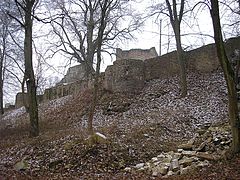
The 14th century curtain wall is reinforced by three semicircular and one rectangular shell tower . In the north and south the defensive wall runs as a kennel around the core castle. In the northwest the remains of a farm yard can be seen, the large vaulted cellar of which has been partially preserved. To the west, the terrain rises steeply to a spacious outer bailey plateau. A modern wooden bridge spans the flat ditch next to the Romanesque residential tower. This outer bailey area was originally fortified by a transverse wall in the area of the farm yard as early as the High Middle Ages .
The castle was secured in several sections from 1975 and partially rebuilt. From 1989 the measures of the castle association were accompanied by archaeological and castle history . The renovation of the castle is not undisputed among experts. The original inventory and the additions cannot always be clearly delineated.
During the Second World War , the bombing of the station area also caused severe damage in the southern part of the ruin. After the end of the war, the inventory was further reduced, partly through vandalism. Until 1975, only the remains of the inner castle and the curtain wall were visible from the extensive complex. The condition at that time is documented on some information boards on the castle grounds.
After the completion of the renovation work, the appearance of the castle ruins is largely determined by the extensive additions. The original high medieval residential tower of the main castle can be climbed as a lookout tower. In the almost completely reconstructed wall shell, even the “scaffolding wood” was left or imitated. The remains of the palace walls are also secured and supplemented. A protective roof was erected over the largely original hearth of the former castle kitchen.
The late medieval curtain wall can be seen again a few meters high. The reconstruction is based on the historical model, at least in the more recent sections with regard to the stone material used and the construction technology. The stumps of the semicircular or rectangular shell towers were also built up to the wall height from the local limestone .

The helmet found in the south kennel

Bridge over the Sohlgraben

Residential tower

The eastern kennel area with the Burglinde and the farmyard

The war memorial on the lower terrace
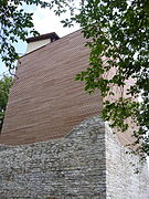
Heightened residential tower in August 2010

General view of the east side of the war memorial (March 2010)
The curtain wall on the east side

.jpg)


Web links
literature
- Treuchtlingen home book . Treuchtlingen 1984.
- J. Lindner: Treuchtlingen - His prehistoric and historical fortifications . Treuchtlingen o. J.
- Gotthard Kießling: Weissenburg-Gunzenhausen district (= Bavarian State Office for Monument Preservation [Hrsg.]: Monuments in Bavaria . Volume V.70 / 1 ). Karl M. Lipp Verlag, Munich 2000, ISBN 3-87490-581-0 .
Individual evidence
- ^ Nordbayern.de: Treuchtlinger Burgverein took stock , January 4, 2011, accessed on February 21, 2011

Castles: Absberg Castle | Altenmuhr Castle | Upper Castle (Berolzheim Market) | Lower Castle (Berolzheim Market) | Cronheim Castle | Dettenheim Castle | Residence Ellingen | Falbenthal Castle | Georgenthal hunting lodge (dismissed) | Geyern Castle | Gunzenhausen Hunting Lodge | Heydenab Palace (Gunzenhausen) | Mittelmuhr Castle (exited) | Möhren Castle | Neuenmuhr Castle (exited) | Old Castle (Pappenheim) | New Castle (Pappenheim) | Old Bailiwick Castle Pleinfeld | Polsingen Castle | Raitenbuch Castle | Sandsee Castle | Spielberg Castle | Stopfenheim Castle | Syburg Castle | Trendel Castle | Treuchtlingen City Palace (Niedere Veste) | Unterwurmbach Castle (exited) | Falkenhausen Castle | Forest Castle | Palais Zocha (Gunzenhausen)
Castles: Bechthal castle ruins | Berolzheim Castle (exited) | Yellow citizens (dismissed) | Geyern Castle (exited) | Hohentrüdingen castle ruins | Neuhaus Castle (exited) | Pappenheim castle ruins | Rechenberg castle ruins | Schambach Castle (exited) | Stahelsberg castle ruins | Trendel Castle (exited) | Treuchtlingen castle ruins (Obere Veste)
Fortresses: Wülzburg
Tower hill castles (all gone): Burg Absberg | Tower Hill Aha | Altenmuhr tower hill | Burgstall Bergen | Tower Hill Buck | Tower hill on Burgstallberg | Emetzheim Castle | Flüglingen Castle | Lunkenburg | Tower Hill Schlossbuck im Hag (Pfofeld Castle) | Burgstall Schlossgraben | Spielberg tower | Burgstall stone house | Burgstall near Treuchtlingen | Tower hill on the vineyard
Castle stables (lost, unknown castles): Burgstall Allmannsdorf | Alte Bürg (Weißenburg in Bayern) | Alte Bürg (Pappenheim) | Burgstall Old Castle | Burgstall section fortification (small vineyard) | Burgstall Buschel (Treuchtlingen) | Burgstall Buschl (Wolfsbronn) | Burgstall Ettenstatt | Burgstall Gersdorf | Burgstall Gundelsheim | Burgstall near Ostheim | Section fortification Schlossberg (Degersheim) | Burgstall Schlossbühl (Gunzenhausen) | Burgstall Schlössle (Treuchtlingen) | Section fortification Schlossleite (Pappenheim) | Burgstall Silberburg | Ringwall Viersteinberg | Section fortification vineyard | Burgstall Weiboldshausen | Burgstall rooms