
Bechthal Castle
| Bechthal Castle | ||
|---|---|---|
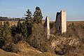
 View of the main castle from the south |
||
| Creation time : | Probably in the 13th century | |
| Castle type : | Höhenburg in spur location | |
| Conservation status: | Restored ruin | |
| Standing position : | Ministerial of the Hochstift Eichstett | |
| Construction: | Ashlar masonry | |
| Place: | Raitenbuch -Bechthal | |
| Geographical location | 49 ° 1 '14.1 " N , 11 ° 10' 41.8" E | |
| Height: | 513 m above sea level NN | |
|
||

The ruin of Bechthal Castle is the restored ruin of a spur castle about 500 meters southeast of the Raitenbuch district of Bechthal on a ridge above the Anlautertal in the Weißenburg-Gunzenhausen district in Middle Franconia . Remnants of the walls and the slim keep have been preserved from the high to late medieval fortifications .
history
The ridge above the Anlautertal served as a partially fortified settlement area during the Urnenfeld , Hallstatt , Latène and Migration Periods .
The high medieval castle is the ancestral seat of the Lords of Pechthal (Bechthal), who first appeared in written sources in the middle of the 12th century. The name of the family could be related to an earlier mining of pitch in this area. In the sparse literature, the lords of the castle are referred to as servants of the Eichstätt bishopric .
As a result, the Pechthaler were apparently able to break away from their dependency on the bishopric and build up a small, independent rule in the area. In 1353 Konrad the Pechthaler had to transfer half of his own vest to Konrad von Heideck and got the property back as a fief . In 1414 Hermann Pechthaler sold the rule to Rüdiger von Erlingshofen. 1473 Sigmund and Caspar Erlingshofer are mentioned as part owners. In 1503 the brothers Christoph and Albrecht Reicharter were co-owners of the castle. In 1544 and 1557 the Eichstätt Monastery acquired both halves of the castle.
After the transfer of ownership to the bishopric, the fortress seems to have become dispensable. The place was administered by the episcopal maintenance office Titting or Raitenbuch. The exact reasons for the abandonment of the castle are unknown. Nuremberg chroniclers report that it was finally destroyed by Swedish artillery during the Thirty Years' War (1633).
In the 19th century the castle was known as "Burg Waldeck". This unhistorical name is probably due to the romantic location on a "wooded corner".
In 1983/84 the ruin could be secured by a renovation.
description
The high medieval castle is located within an older section fortification . The elongated ridge is secured by a total of five trenches, the exact time of which is unclear.
Two spacious outer bailey plateaus extend east of the partly preserved main castle . The end of the terrain spur is surrounded by a quarry stone wall that has been preserved as a foundation . About 55 meters in front of the deep eastern neck ditch of the core castle , an approximately three meter high moat can be seen. The wall goes back to a mostly collapsed limestone wall. Further remains of the wall can be seen on the outer bailey plateau.
The eastern neck ditch is mostly carved out of the rock and up to 10 meters deep. The almost square main castle cone (approx. 30 × 35 meters) behind it is surrounded in the south and west by a shallow, angular inner ditch, which continues as a terrace to the north . The soil removed for this purpose was heaped up on the slope to form two mighty slope terraces.
To the west of the main castle is a narrow rock reef, in front of which a section trench was created. After about 40 meters, the rugged foreland is again pierced by a shallow trench.
The main castle

Most of the masonry of the relatively small core castle was removed and reused. The square, approximately 30 meter high keep with a side length of 5.5 meters and a wall thickness of 1.5 meters is best preserved. The tower consists of smaller, cuboid-shaped limestone quarries of local origin. On the west side, the obligatory high entrance leads into the interior with its vaulted second floor.
Only remains of foundations and rubble walls on the castle plateau tell of the rest of the interior development. The residential building is likely to have been in the northwest in front of the keep. The striking ruins of a narrow rectangular tower with a few light openings rise above the southwest corner.
Large parts of the filling works of the former outer wall can still be seen on the south side of the castle. In some places, the outer shell made of rubble has been preserved.
The Bavarian State Office for the Preservation of Monuments lists the Burgplatz as a settlement of the Urnfields, Hallstatt, Latène and Migration Periods as well as a medieval castle stables with underground components of the "Waldeck" castle ruins under monument number D-5-6933-0316.

Keep with the arched high entrance

Remains of the tower in the southwest
View of the main castle from the west

View of the main castle from the southeast


literature
- Gotthard Kießling: Weissenburg-Gunzenhausen district (= Bavarian State Office for Monument Preservation [Hrsg.]: Monuments in Bavaria . Volume V.70 / 1 ). Karl M. Lipp Verlag, Munich 2000, ISBN 3-87490-581-0 .
- Felix Mader , Karl Gröber (edit.): The art monuments of Middle Franconia, V, city and district office Weissenburg i. B. (The art monuments of Bavaria, administrative region Middle Franconia, V) Munich 1932.
- Konrad Spindler (edit.): Guide to archaeological monuments in Germany, Volume 15: Weissenburg-Gunzenhausen district - monuments and sites . Konrad Theiss Verlag, Stuttgart 1987, ISBN 3-8062-0504-3 , pp. 15-16.
Web links
- Bechthal castle ruins on burgseite.de
- Burg Bechthal on the homepage of the House of Bavarian History (plans, history, building history, building stock)
Individual evidence
- ↑ Bavarian State Office for Monument Preservation: Entry ( Memento of the original from September 17, 2016 in the Internet Archive ) Info: The archive link was inserted automatically and has not yet been checked. Please check the original and archive link according to the instructions and then remove this notice.

Castles: Absberg Castle | Altenmuhr Castle | Upper Castle (Berolzheim Market) | Lower Castle (Berolzheim Market) | Cronheim Castle | Dettenheim Castle | Residence Ellingen | Falbenthal Castle | Georgenthal hunting lodge (dismissed) | Geyern Castle | Gunzenhausen Hunting Lodge | Heydenab Palace (Gunzenhausen) | Mittelmuhr Castle (exited) | Möhren Castle | Neuenmuhr Castle (exited) | Old Castle (Pappenheim) | New Castle (Pappenheim) | Old Bailiwick Castle Pleinfeld | Polsingen Castle | Raitenbuch Castle | Sandsee Castle | Spielberg Castle | Stopfenheim Castle | Syburg Castle | Trendel Castle | Treuchtlingen City Palace (Niedere Veste) | Unterwurmbach Castle (exited) | Falkenhausen Castle | Forest Castle | Palais Zocha (Gunzenhausen)
Castles: Bechthal castle ruins | Berolzheim Castle (exited) | Yellow citizens (dismissed) | Geyern Castle (exited) | Hohentrüdingen castle ruins | Neuhaus Castle (exited) | Pappenheim castle ruins | Rechenberg castle ruins | Schambach Castle (exited) | Stahelsberg castle ruins | Trendel Castle (exited) | Treuchtlingen castle ruins (Obere Veste)
Fortresses: Wülzburg
Tower hill castles (all gone): Burg Absberg | Tower Hill Aha | Altenmuhr tower hill | Burgstall Bergen | Tower Hill Buck | Tower hill on Burgstallberg | Emetzheim Castle | Flüglingen Castle | Lunkenburg | Tower Hill Schlossbuck im Hag (Pfofeld Castle) | Burgstall Schlossgraben | Spielberg tower | Burgstall stone house | Burgstall near Treuchtlingen | Tower hill on the vineyard
Castle stables (lost, unknown castles): Burgstall Allmannsdorf | Alte Bürg (Weißenburg in Bayern) | Alte Bürg (Pappenheim) | Burgstall Old Castle | Burgstall section fortification (small vineyard) | Burgstall Buschel (Treuchtlingen) | Burgstall Buschl (Wolfsbronn) | Burgstall Ettenstatt | Burgstall Gersdorf | Burgstall Gundelsheim | Burgstall near Ostheim | Section fortification Schlossberg (Degersheim) | Burgstall Schlossbühl (Gunzenhausen) | Burgstall Schlössle (Treuchtlingen) | Section fortification Schlossleite (Pappenheim) | Burgstall Silberburg | Ringwall Viersteinberg | Section fortification vineyard | Burgstall Weiboldshausen | Burgstall rooms