
Pfofeld
| coat of arms | Germany map | |
|---|---|---|

|
Coordinates: 49 ° 6 ' N , 10 ° 50' E |
|
| Basic data | ||
| State : | Bavaria | |
| Administrative region : | Middle Franconia | |
| County : | Weissenburg-Gunzenhausen | |
| Management Community : | Gunzenhausen | |
| Height : | 446 m above sea level NHN | |
| Area : | 23.89 km 2 | |
| Residents: | 1529 (Dec. 31, 2019) | |
| Population density : | 64 inhabitants per km 2 | |
| Postal code : | 91738 | |
| Area code : | 09834 | |
| License plate : | WUG, GUN | |
| Community key : | 09 5 77 159 | |
| Community structure: | 13 parts of the community | |
| Association administration address: | Frankenmuther Str. 2 d 91710 Gunzenhausen |
|
| Website : | ||
| Mayor : | Reinhold Huber | |
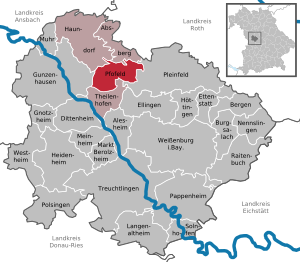
| Location of the community Pfofeld in the Weißenburg-Gunzenhausen district | ||
  |
||

Pfofeld is a municipality in the central Franconian district of Weißenburg-Gunzenhausen and a member of the Gunzenhausen administrative community .
geography
Geographical location
.jpg)

Pfofeld is located in the West Central Franconia region , about five kilometers east of Gunzenhausen . In the north of the municipality there are partly the Große Brombachsee and its pre-barrier Kleiner Brombachsee as well as the Altmühlüberleiter . In earlier times the Limes ran through the municipality . The European main watershed runs through the municipality and divides the catchment areas of the Rhine and Danube from one another. The Dornhauser Mühlbach flows through Pfofeld ; The Bachwiesengraben and the Buxbach as well as the Brombach also flow into the municipality . The municipality is characterized by hills and forests, including the Weißenberg and the Graefensteinberg Forest . State road 2222 passes north of Pfofeld . The municipality includes the nature reserves Brombachmoor and peninsula in the Kleiner Brombachsee .
Community structure
The municipality has 13 officially named parts of the municipality (the type of place is given in brackets ):
|
|
|
Neighboring communities
| Absberg , Haundorf | ||
| Gunzenhausen |
.svg)
|
Pleinfeld |
| Theilenhofen |
history
Until the church is planted
The first written mention of Pfofeld tells of a local noble family. Around 1180/90 Dietericus de Pfaluelt (u = v) was one of the witnesses when the noble Adelold von Pfraunfeld and Adelheid donated their property in Pfraunfeld to the church of St. John the Baptist in Rebdorf .
The Principality of Ansbach , the Bishopric of Eichstätt , the imperial city of White Castle and Deutschordensballei Franken claimed herein domination . All four institutions belonged to the Franconian Reichskreis from 1500 . It was not until 1796 that the Prussian principality of Ansbach , which had been in existence since 1792, was able to assert itself . In the Treaty of Paris (February 1806), Pfofeld and the Principality of Ansbach were exchanged for the Kingdom of Bavaria . In 1818 the political municipality was established.
Incorporations
On May 1, 1978, parts of the dissolved municipality of Thannhausen, which had about 250 inhabitants at that time , were incorporated as part of the municipal reform.
Population development
- 1961: 1441 inhabitants
- 1970: 1259 inhabitants
- 1987: 1180 inhabitants
- 1991: 1296 inhabitants
- 1995: 1459 inhabitants
- 2000: 1443 inhabitants
- 2005: 1451 inhabitants
- 2010: 1502 inhabitants
- 2015: 1528 inhabitants
Name and coat of arms
Pfofeld is one of the few places in Bavaria whose name is related to the Limes . Pfofeld means something like "field on the stake", where stake is another historical name for the Limes. In front of the stone wall, the border was secured with a wooden palisade, i.e. with posts. Accordingly, the local coat of arms symbolically consists of three wooden piles connected to one another.
The description of the coat of arms reads: In black, three pointed silver stakes, which are connected to each other by a silver mesh.
Culture and sights
Buildings
.JPG)
- The Evangelical Lutheran parish church of St. Michael is the oldest church in the Altmühl area, the Romanesque construction is still clearly visible. It is decorated with late Gothic frescoes.
- To the southwest are the ruins of the Holy Cross Chapel , a former pilgrimage site that was destroyed in the Thirty Years War .
- In the small forest immediately west of Pfofeld there is a medieval castle stable , the so-called tower hill Schlossbuck im Hag . This is where the Pfofelder local nobility, who was named between 1180 and 1190 with "Dietericus de [= von] Pfaluelt" , probably sat .
Nature reserves

The nature reserves Brombachmoor , peninsula in the Kleiner Brombachsee and Grafemühle on the south bank of the Großer Brombachsee are located in the municipality .
Economy and Infrastructure
Economy including agriculture and forestry
The municipal tax revenue amounted to the equivalent of 562,000 euros in 1999, of which 61,000 euros (net) were trade tax revenues.
In 1998, according to official statistics, there were no employees at the place of work in the manufacturing sector 34 or in the trade and transport sector. 135 people were employed subject to social security contributions in other economic sectors. There were a total of 525 employees at the place of residence subject to social security contributions. There were five companies in the manufacturing sector and two in the construction sector. In addition, in 1999 there were 67 farms with an agricultural area of 1098 hectares, of which 673 hectares were arable land.
traffic
The district road WUG 1 , which connects the place with the federal road 13 , runs through Pfofeld . There is a connection to the railway network in the Langlau district through a stop on the Gunzenhausen – Pleinfeld railway line .
Long-distance cycle routes
The German Limes Cycle Path runs through the district of Thannhausen . It follows the Upper German-Raetian Limes over 818 km from Bad Hönningen on the Rhine to Regensburg on the Danube .
Long-distance hiking trails
North of Pfofeld extending Limes trail , a section of the German Limes trail .
education
In 1999 the following institutions existed:
- Kindergartens: 75 kindergarten places with 66 children
- A primary school in the Langlau district
Personalities

- Erich Behrendt (1899–1983), painter, graphic artist and illustrator; spent the last 16 years of his life in Langlau.
literature
- Our community Pfofeld between Limes and Brombachsee, insights into 2500 years of history. Published by the Pfofeld community, Gunzenhausen 2009
- Johann Kaspar Bundschuh : Pfohefeld . In: Geographical Statistical-Topographical Lexicon of Franconia . tape 4 : Ni-R . Verlag der Stettinische Buchhandlung, Ulm 1801, DNB 790364301 , OCLC 833753101 , Sp. 345-346 ( digitized version ).
- Gottfried Stieber: Pfohefeld . In: Historical and topographical news from the Principality of Brandenburg-Onolzbach . Johann Jacob Enderes, Schwabach 1761, p. 626-627 ( digitized version ).
Web links
- Homepage Pfofeld
- Entry on Pfofeld's coat of arms in the database of the House of Bavarian History
Individual evidence
- ↑ "Data 2" sheet, Statistical Report A1200C 202041 Population of the municipalities, districts and administrative districts 1st quarter 2020 (population based on the 2011 census) ( help ).
- ^ Community Pfofeld in the local database of the Bavarian State Library Online . Bayerische Staatsbibliothek, accessed on December 25, 2019.
- ↑ State Archives Nuremberg, Hochstift Eichstätt, Rep. 192/8, Rebdorf Abbey, U No. 4
- ↑ a b c Federal Statistical Office (ed.): Historical municipality directory for the Federal Republic of Germany. Name, border and key number changes in municipalities, counties and administrative districts from May 27, 1970 to December 31, 1982 . W. Kohlhammer, Stuttgart / Mainz 1983, ISBN 3-17-003263-1 , p. 731 .
- ^ Johann Schrenk: Altmühltal - Franconian Lake District . 10th edition. Michael Müller Verlag, 2017, ISBN 978-3-95654-192-6 , p. 92 .
- ^ Evangelical Lutheran. Parish church St. Michael Pfofeld Altmühlfranken . Pfofeld n.d. (n.p.)

Absberg | Alesheim | Mountains | Burgsalach | Dittenheim | Ellingen | Ettenstatt | Gnotzheim | Gunzenhausen | Haundorf | Heidenheim | Höttingen | Langenaltheim | Berolzheim market | Meinheim | Muhr am See | Nennslingen | Pappenheim | Pfofeld | Pleinfeld | Polsingen | Raitenbuch | Solnhofen | Theilenhofen | Treuchtlingen | Weißenburg in Bavaria | Westheim
Bag mill | Furthmühle | Grafenmühle | Gundelshalm | Chicken mill | Langlau | Neuherberg | Neumühle | Pfofeld | Rehenbühl | Scheermühle | Sorghof | Thannhausen