Limes hiking trail (Altmühltal Nature Park)
| Limes hiking trail (Altmühltal Nature Park) | |
|---|---|
| Data | |
| length | approx. 115 km |
| location | Bavaria |
| Supervised by | Altmühltal Nature Park Tourist Association , Franconian Alb Association |
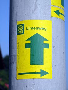
| Markers | stylized Roman watchtower in dark green color in a yellow rectangle |
| Starting point |
Gunzenhausen 49 ° 6 ′ 53 ″ N , 10 ° 45 ′ 15 ″ E |
| Target point |
Bad Gögging 48 ° 49 ′ 35 ″ N , 11 ° 46 ′ 50 ″ E |
| Type | Long-distance hiking trail |
| Level of difficulty | easy |
| season | all year round |
The Limeswanderweg , or Limesweg for short , is an approx. 115 km long route from Gunzenhausen to Bad Gögging , which largely follows the course of the Rhaetian Limes to the Danube .
Route
The Limes hiking trail begins in Gunzenhausen on the Altmühl promenade , grazes the fort and runs in an easterly direction, mostly following the course of the Limes. Pfofeld is bypassed to the north, Thannhausen to the south. When the path reaches the valley of the Swabian Rezat , it leaves the Limes to the south and reaches Ellingen .
Past the Sablonetum fort and via Höttingen , the hiking trail returns to the Limes and overcomes the eaves of the Franconian Alb at the Steinerne Rinne von Rohrbach . At Oberhochstatt and Burgsalach two forts are touched again before the Limes - and thus also the path - shows a clear bend at Petersbuch .
About Erkertshofen , Hirnstetten and Pfahldorf is Kipfenberg in Altmühltal reached. The hiking trail passes the geographical center of Bavaria and touches the outskirts of Denkendorf . Behind Zandt , a longer forest stretch leads through the Köschinger Forest to Sandersdorf and Altmannstein .
The Limes finally reaches the Danube Valley via Hagenhill and Laimerstadt . The hiking trail continues south through Hienheim and crosses the Danube with the ferry from Eining . Past the Abusina fort , the path finally arrives at its end in Bad Gögging with the Limestherme.
Path maintenance and marking
Waymark is a stylized Roman watchtower in dark green in a yellow rectangle. In the upper part of the rectangle is the logo of the Altmühltal Nature Park and the text Limesweg .
The path is marked in both directions, so it can be walked just as easily from Bad Gögging to Gunzenhausen.
The Altmühltal Nature Park Tourism Association with the support of the Franconian Alb Association is responsible for maintaining the path and marking it .
Stages
The following stage recommendation is aimed at experienced and well-trained hikers:
- Stage 1: Gunzenhausen - Dorsbrunn - Ellingen. Length 23 km, ascent 395 m, descent 411 m
- Stage 2: Ellingen - Höttingen - Oberhochstatt - Erkertshofen. Length 31 km, ascent 503 m, descent 376 m
- Stage 3: Erkertshofen - Hirnstetten - Pfahldorf - Kipfenberg - Denkendorf. Length 22 km, ascent 543 m, descent 573 m
- Stage 4: Denkendorf - Zandt - Sandersdorf - Altmannstein. Length 18 km, ascent 364 m, descent 471 m
- Stage 5: Altmannstein - Hagenhill - Laimerstadt - Hienheim - Eining - Bad Gögging. Length 22 km, ascent 328 m, descent 358 m
There is also a 22 km long loop path from Oberhochstatt to Weißenburg to the Biriciana Fort and back.
Connection to other Limes routes
The path is the most easterly of a whole series of Limes hiking trails which, as the German Limes hiking trail, open up the Upper German-Rhaetian Limes to hikers in full. The Franconian Albverein has marked a 40 km long Limesweg west of Gunzenhausen to Wilburgstetten an der Wörnitz , where the Limesweg of the Swabian Albverein connects.
literature
- Thorsten Lensing: Limesweg. Bergverlag Rother , Munich 2013, ISBN 978-3-7633-4432-1 .
- Upper Germanic-Raetian Limes in Bavaria from Mönchsroth to Eining (Danube). Pustet , Regensburg 2008, ISBN 978-3-7917-2127-9 . (Also included in: Official map set 1:50 000 UNESCO World Heritage Site Upper Germanic-Raetian Limes. State Office for Geoinformation and Rural Development Baden-Württemberg , Stuttgart, ISBN 978-3-89021-777-2 )
