
Eining Castle
| Eining Castle | |
|---|---|
| Alternative name | Abusina , Ausina , Allusina , Ausena , Arusena |
| limes | ORL NN ( RLK ) |
| Route (RLK) | 15; Rhaetian Limes; Danube-Iller-Rhein-Limes of Raetia II |
| Dating (occupancy) | around 80 AD to 5th century |
| Type | Cohort fort |
| unit | a) Cohors IIII Gallorum b) Vexillatio of the Cohors II Tungrorum milliaria equitata c) Vexillatio of the Cohors IIII Tungrorum milliaria equitata d) Cohors III Britannorum equitata |
| size | Max. 147 × 125 m = 1.8 ha |
| Construction | a) wood-earth b) stone |
| State of preservation | exposed and preserved |
| place | Neustadt an der Donau - Bad Gögging / Eining |
| Geographical location | 48 ° 50 ′ 59 " N , 11 ° 46 ′ 15" E |
| height | 360 m above sea level NHN |
| Previous | ORL 75 Fort Pförring (west) |
| Subsequently |
Vexillation camp Eining-Unterfeld (north) Small fort Weltenburg-Frauenberg (north) Burgus Thaldorf (north-east) |
| Upstream | Small fort Hienheim (north) |
The fort Eining (Latin Abusina ) was a Roman military camp , whose crew for safety and monitoring tasks on wet Raetian was responsible Limes. The Danube formed the Roman frontier in large sections. A little further north also led to the limit case of the Upper German-Rhaetian Limes one on the western riverbank. The structural remains of the facility are located south of Eining , a district of Neustadt an der Donau , Free State of Bavaria , Federal Republic of Germany. Abusina is part of the UNESCO World Heritage Site collected Rhaetian Limes and one of the few fully exposed and reconstructed in its foundations fortifications at this border section.
location
The fort Abusina is located approximately 500 meters south of the present Eininger town center on the Danube -Hochufer between the after Sittling leading road and just north of the fort in the Danube opens river Abens , once its name to the Roman site.
In ancient times it was in a strategically and geographically important position. From there, both shipping traffic on the Danube and a road junction at this point could be controlled, where one traffic route branched off from the Roman Donausüdstraße in a south-easterly direction and another led across a Danube ford to the west. The closest larger garrisons were the Alen - Fort Pförring on the northern bank of the Danube, opposite today's Neustadt an der Donau , and the Legion camp Castra Regina , today's Regensburg . A small disadvantage of the location was the lack of line of sight to Fort Pförring and to the beginning of the Limes section near Hienheim, which was also on the northern bank of the Danube . It could be compensated by an additional watchtower on the vineyard .
Research history


The name Abusina had long been known through various ancient sources, but appeared in different spellings. The variants ABVSINA, AVSINA, ALLVSINA, AVSENA and ARVSENA can be found on the Tabula Peutingeriana , in the Itinerarium Antonini , in the Notitia dignitatum and on inscription stones . Humanistic scholars of the early modern era already knew about the former Roman settlement in the area around Eining. In addition to Johannes Aventinus (1477–1534), it was also Peter Apian (1495–1552) who secured lost stone monuments in Eining. The scholars were able to correctly identify the remains of the ancient wall with Abusina through their research . After that, the fort was forgotten again for a few hundred years, until in the 19th century the interest of educated middle classes turned to the ancient evidence in Germany.
The fort was not recorded by the activities of the Reichs-Limeskommission (RLK), founded in 1892 , as the area under investigation ended with the end of the Limes wall on the western bank of the Danube near Hienheim . The fort square owes the beginning of his research to the initiative of the Einingen pastor Wolfgang Schreiner, who began the first excavations in 1879 , which he initially financed with private funds. Under the direction of the then regional archaeologist Paul Reinecke (1872-1958), the excavations continued between 1911 and 1920 with occasional interruptions. After that, scientific research was suspended for almost half a century. Scientific research was not resumed until 1968 on the initiative of the Roman provincial archaeologist Hans Schönberger (1916–2005), then director of the Roman-Germanic Commission of the German Archaeological Institute (DAI).
In a competition to give the fort area a new face, a team of designers from Düsseldorf prevailed in 2010 . It had submitted plans to distribute several constructions, some of them oversized steel plates, in the excavation area in order to "revive" the archaeological site. In addition, a new entrance area, toilets and a network of paths for visitors were planned in today's park-like landscape. Hidden wall remnants should be “sensually perceptible” with “herb planting”. The tenant of Abusina , the Historia Romana association, had raised concerns about the plans in contrast to the public sector and would have seen the considerable funds required invested in the maintenance of the ancient building remains. These concerns did not prevail. When the concept was completed in 2011, the site was named Roman Park Abusina Eining. In addition to the rusty steel plate gates that now dominate the site, which were erected directly in front of the ancient gate and building entrances, the concept did not shy away from installations and thus visual changes to the ancient substance to undertake. For example, those responsible had a concrete and steel structure placed in the middle of the access to the porta decumana on the river side from the Middle Imperial period , which extends as a footbridge over the sloping terrain. The steel plates also serve as "listening stations". In the fort area, noises can now be heard in various places that are supposed to remind of life 2000 years ago, such as hoofs clatter and roaring Romans. Instead of the wooden pavilion with information and finds in the north of the fort, which was set up at the end of the 20th century, a construction made of steel, glass and concrete, which also serves as a viewing platform, was built.
The not inconsiderable finds from Eining are mainly distributed among the Archaeological Museum of the City of Kelheim , the City and District Museum Landshut , the Archaeological State Collection Munich and the City Museum Abensberg . The fort area itself is now a small but attractive archaeological park.
Fort and vicus history
According to the founding inscription , the Abusina fort was built during the reign of the Flavian Emperor Titus (79-81) around the year 80 AD by the Cohors IIII Gallorum (4th cohort of the Gauls) to secure the Danube line as part of the northern border of the Roman Empire built. This cohort was also the first regular unit to move into the new fort. In its first construction phase, the camp consisted of a fence in a wood-earth construction and inside of quite simple half-timbered buildings.
In the early 2nd century, probably towards the end of the reign of Emperor Trajan , the Gauls cohort was replaced by a Vexillatio , a detachment of the Cohors II Tungrorum milliaria equitata (2nd partially mounted double cohort of the Tungrians ) consisting of a good 500 to 600 men . This assignment is an example of the mobility, flexibility and thus modernity of the Exercitus Romanorum , the Roman army. While the main unit remained stationed in Britain , it was easily possible to deploy the detachment of this force in the distant Danube region in the meantime. A little later, between 138 and 147, the vexillatio of a sister unit, the Cohors IIII Tungrorum milliaria equitata , probably took its place for a few years.
From 153 the Cohors III Britannorum equitata (3rd partially mounted British cohort) with six centuries of infantry and six towers of cavalry is recorded in Eining. It remained there until the final end of Roman rule over the province of Raetia in the early 5th century. One of their first tasks was to convert the camp into a stone fort. This measure was related to a coordinated strengthening of the entire regional Limes section in Antonine times.
The need for expansion work soon became apparent. During the Marcomannic Wars in the reign of Emperor Mark Aurel (161-180), the province of Raetia was in dire straits and at least partially and temporarily escaped Roman control. The fort and vicus of Eining were also destroyed for the first time. The area between Abusina and Castra Regina was probably not brought back under control until around 175 AD by the Legio III Italica (3rd Italian Legion) stationed in Regensburg . Parts of this legion were temporarily stationed in the Flur Unterfeld north of Eining for around ten years from around 172 AD .
After the rebuilding of the fort and the camp village, Abusina began a phase of calm and prosperity that lasted into the first third of the 3rd century . The political highlight of this period was the visit of the Emperor Caracalla in Eining in 213. Caracalla had to Raetien go to a preventive war against the north, the Danube threatening concentrating Alemanni to coordinate. The military operations now initiated were so successful that they freed the province, and with it Abusina, from the pressure of the Alemanni for another two decades.
From the year 233, the relatively stable times for the border residents were a thing of the past. In the course of the first Alemanni invasion, Abusina was destroyed again. Further waves of Alemannic raids and conquests followed, until in 260 the Roman border defense in Raetia almost completely collapsed and the province sank into chaos. Eining was also burned down again in this last Alemanni storm. Numerous hoard finds, including the famous “Eining custody find”, which was discovered by chance in 1975, bear witness to this time. The custody find from Eining is one of the most important archaeological discoveries in Bavaria , along with the treasure finds from Weißenburg and Straubing , and contains parts of Roman parade armor. It was documented by Hans-Jörg Kellner and is now in the Archaeological State Collection in Munich. The 3rd British Cohort and the 3rd Italian Legion were among the few surviving military units and were the last stabilizing factors in the region.
The Abusina cohort stayed in its garrison until the Diocletian - Constantinian army reforms at the end of the 3rd and beginning of the 4th century and the expansion of the Danube-Iller-Rhein-Limes could calm the situation in the border areas. The reforms created a larger mobile army stationed in the hinterland and reduced the strength of the troops standing directly on the border, whose barracks were converted into smaller and more fortified burgi . At the same time, the western flank of Raetia , which was created by the loss of the Agri decumates , was strengthened by the expansion of the Limes . The changes in the Roman army structure are reflected in the Eining fort. The staff of the British cohort was presumably reduced to 140 men and in the south-west corner of the old fort a small castle-like fortress was built, including ditches, on less than a quarter of the previous area. The barriers for the remaining three quarters were also maintained in the period that followed; the old fort area was used by both the military and the civilian population. The latter had not rebuilt the old Eininger vicus after 260, but sought protection behind the walls of the fort.
The final fall of Abusina occurred around the middle of the 5th century, probably as a result of an advance by the Alamanni from the west. It is possible that the last Romanesque population group remaining under the protection of the fortification belonged to those who were saved by the evacuation measures of Severin von Noricum .
The core of the Bavarian settlement of Oweninga, from which today's Eining emerged, was formed around 500 m north of Abusina and was not built until the 6th or 7th century, so there is no continuity of settlement there.
Castle findings


Due to the repeated changes in the strategic framework and multiple destruction in the long period of its existence, the Abusina castle was rebuilt and rebuilt several times . This led to a high level of complexity in the building findings.
Nothing is left of the original wood and earth fort from the Flavian era. In its ground plans, however, it was decisive for all subsequent stone forts before the beginning of late antiquity. With a length of 147 meters and a width of 125 meters, it covered an area of around 1.8 hectares and thus corresponded to the average size of a Roman cohort fort with cavalry. Initially the fort with its Porta Praetoria (main gate) was oriented to the north, only with the conversion to a stone fort in the middle of the 2nd century did the main exit gate point to the east. This change in the interior structure is largely responsible for today's asymmetrical image.
The Imperial military camp of Eining was surrounded on three sides by a double pointed ditch. Each trench was 8 meters wide and 4 meters deep. The rift system towards the Danube was interrupted, probably because the steeply sloping bank and the river itself were sufficient obstacles to approach. The defense wall of the four-gate fort, rounded at the corners, was 1.4 meters thick and probably 5 meters high. In addition , an earth ramp was built on the inside of the wall of the Agger . The wall was reinforced with towers at its corners, at the gates and between corners and gates.
In the center of the interior of the fort are the still visible walls of the Principia , the staff building. There were the offices (Tabularia) , the armory and under the flag sanctuary (Aedes) the troop chest. A little north of the Principia was the Praetorium , the commandant's spacious and comfortable residential building. In addition, the warehouse had all the usual equipment features for its size. Of these buildings, the team barracks, horse stables, workshops, the hospital and the detention building, nothing is visible anymore. In the fort area the remains of a tank statue were found, as it once stood for the emperor in the flag shrine. These fragments date to the first half of the 3rd century.
In late antiquity, the fort was significantly reduced in size (0.18 hectares). A strong fortified, castle-like small fort was built in its southwest corner. Parts of the external fence of the old warehouse were included in the new building; the new fortification separated from the remaining area with a weir ditch. Including this moat, the Burgus had less than a quarter of the garrison's original area. The remainder served the civilian population, which had been severely decimated by the wars, as a new living area in place of the abandoned vicus . In the time of Valentine, a 9.50 × 19.50 meter large horreum with a central tower in the north wall was probably built in front of the north wall, with the fort wall being used as a rear wall. Buttresses in the northeast and northwest corners, a screed floor and grain finds strongly suggest a storage building. Possibly it obstructed the field of vision and the field of fire from the adjacent towers, which is why an additional tower was placed in front of the horreum and this resulted in this unusual shape. In the middle of the 5th century the use of the Eining fort ended.
- Castle findings

Heatable building on the northern edge of the Principia

Fishing hole for a gate wing on the west tower of the Porta Principalis Sinistra

Herringbone pattern on the inner cheek of the north wall of the late antique Burgus
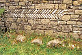
Herringbone pattern on the west side of the northeast tower in Burgus. Half-cylindrical battlements of the mid-imperial fort are built into the foundation

Clavicle gate of late antique Burgus


Vicus findings
The Eining military camp was surrounded by a fan-shaped civil settlement, a vicus . Its main traffic axes were the Donausüdstraße, which had been arched around the fort, and the traffic route that branched off from this street to the east immediately in front of the Porta Praetoria . The extent of the vicus was about 500 meters in each direction from the fort gate, so that at the heyday of the camp village there was an extension of about one kilometer in north-south and almost half a kilometer in west-east.
The relatives of active soldiers settled there, as did traders, craftsmen and innkeepers who met the needs of the military camp for goods and services. Soldiers who had finished their service were added later, as was shown by numerous dismissal certificates, so-called military diplomas, that were found during the excavations. Most of the buildings in the vicus were simple half-timbered houses, but there were also a few stone buildings, some with underfloor heating and up to 50 meters long. They could be verified by means of field archaeological methods and aerial photo archeology .
Immediately outside the fort walls there were two bathing facilities one after the other. A first small thermal bath was built on the steep bank of the Danube, but had to be abandoned soon because of the permanent risk of flooding. It was replaced by a large, representative thermal bath north of the fort that was provided with all the modern comforts.
Also in front of the northern front of the camp was a large, heated mansio with a small bathing wing , a hostel and horse changing station for business travelers on behalf of the state. The mansio von Eining was also the headquarters of the beneficiaries , a type of road police with customs powers that was responsible for the security of the Roman road network.
- Abusina thermal baths and mansio
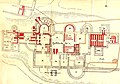
Große Therme,
excavation plan from 1887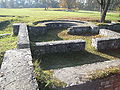
Large bath building
(presumably the caldarium )
Hypocaust
in the small bath building
Late antique bath from the time of Burgus

Mansio


The vicus of Abusina was destroyed and rebuilt several times in its 180-year history. After the great Alemanni storm of 260 it was abandoned. The surviving population then withdrew behind the protective walls of the fort.
Watchtower on the vineyard
Since there was no direct line of sight from Abusina fort to the next fort in Pförring and to where the developed part of the Limes met the Danube northeast of Hienheim , a watchtower was built on the vineyard northeast of Eining to close the gap. It existed until the 3rd century and was probably destroyed by the Alemanni invasions. Immediately at its foundations, two other stone structures could be detected, which belonged to a crew accommodation for the crew of the watchtower and to a small temple of Mars and Victoria .
The rubble of these facilities also gave evidence of the use of the square as a Christian place of worship in post-Roman and early medieval times. Possibly the used from the 6./7. In the 18th century, baioarii, who settled in this area, laid the foundations of the crew quarters to build a simple church.
Vexillation camp in the subfield
Main article: Eining-Unterfeld vexillation camp
Just a little north outside the town center of Eining, under the fields of the Flur Unterfeld, are the remains of a large Roman military camp. With its sides of 328 × 320 meters, it covers an area of 10.6 hectares. Today the area is cut through by the road from Eining to Staubing , which roughly follows the course of the former Via Principalis . The military camp was probably the site of a vexillation of the Legio III Italica (3rd Italian Legion), presumably reinforced and protected by mounted auxiliary troops . Exact certainty about the function of the camp can only be obtained through large-scale excavations.
Monument protection
The Abusina Fort and the facilities mentioned have been part of the UNESCO World Heritage as a section of the Upper German-Rhaetian Limes since 2005. In addition, they are protected as registered ground monuments within the meaning of the Bavarian Monument Protection Act (BayDSchG). Investigations and targeted collection of finds are subject to authorization, accidental finds must be reported to the monument authorities.
See also
List of forts in the Danube-Iller-Rhein-Limes
literature
- Dietwulf Baatz : The Roman Limes. Archaeological excursions between the Rhine and the Danube. 4th edition, Gebr. Mann, Berlin 2000, ISBN 3-7861-2347-0 , p. 322 ff.
- Jörg Faßbinder, Roland Linck, Tomasz Gorka, Thomas Deller, Lena Kühne: Geophysical prospection in the fort and Vicus Eining. In: The Archaeological Year in Bavaria 2009. Stuttgart 2010. pp. 92–95.
- Thomas Fischer : The Roman fort Eining and its surroundings (Archeology in Bavaria guide). Pustet, Regensburg 2016, ISBN 978-3-7917-2841-4
- Thomas Fischer, Erika Riedmeier Fischer: The Roman Limes in Bavaria. Verlag Friedrich Pustet, Regensburg 2008. ISBN 978-3-7917-2120-0 .
- Thomas Fischer: Eining Stadt Neustadt ad Donau, district Kelheim, Obb. In: Wolfgang Czysz u. a .: The Romans in Bavaria. Nikol, Hamburg 2005, ISBN 3-937872-11-6 , p. 434 ff.
- Thomas Fischer: forts Ruffenhofen, Dambach, Unterschwaningen, Gnotzheim, Gunzenhausen, Theilenhofen, Böhming, Pfünz, Eining. In: Jochen Garbsch (Ed.): The Roman Limes in Bavaria. 100 years of Limes research in Bavaria. Exhibition catalogs of the Prehistoric State Collection 22, 1992, p. 37 ff.
- Thomas Fischer, Konrad Spindler: The Roman border fort Abusina-Eining. Theiss, Stuttgart 1984. (Guide to archaeological monuments in Bavaria: Niederbayern 1), ISBN 3-8062-0390-3 .
- Thomas Fischer, Günter Ulbert : The Limes in Bavaria. From Dinkelsbühl to Eining. Theiss, Stuttgart 1983, ISBN 3-8062-0351-2 , p. 106 ff.
- Christof Flügel: A Roman bronze shaft with reliefs of gods from Eining, district of Kelheim . In: Bavarian History Sheets 64, 1999, p. 393
- Markus Gschwind : Abusina. The Roman auxiliary fort Eining on the Danube from the 1st to 5th centuries AD. Beck, Munich 2004. (Munich contributions to prehistory and early history, 53), ISBN 3-406-10755-9 .
- Ute Jäger: The Romans on the Danube. Bad Gögging, Eining Castle . Wek-Verlag , Treuchtlingen 1993, ISBN 3-924828-53-9 .
- Hans-Jörg Kellner: The Roman deposit of Eining . Beck, Munich 1978. (Munich contributions to prehistory and early history, 53), ISBN 3-406-00499-7 .
- Erdmute Lipper: The animal bone finds from the Roman fort Abusina - Eining, city of Neuburg a. d. Danube, district of Kelheim . In: Report of Bayerische Bodendenkmalpflege 22/23, 1981/82 (1986), pp. 81–156.
- Krešimir Matijević : Epigraphic notes on the so-called "Caracalla Altar" in Abusina / Eining-Raetia (CIL III 5935) . In: Frankfurter Electronic Rundschau zur Altertumskunde 17, 2012, 1-11. (PDF; 9.5 MB)
- Krešimir Matijević (Ed.): Salve Abusina! An archaeological-historical museum guide through the Roman auxiliary fort of Abusina / Eining and its vicus , Regensburg 2012. ISBN 978-3-937527-50-5
- Paul Reinecke : The Roman border fort Abusina near Eining - Donau , A. Kettner book printing, Riedenburg 1957.
- Michael Maria Rind : A destroyed Roman cremation grave. News about the localization of the Eining burial ground ::. In: Michael Maria Rind (Ed.): From Celtic Warriors and Church Mice (= Archeology in the District of Kelheim 2), Regensburg 1997, p. 163 f.
- Michael Maria Rind: New excavation results for the Roman Eining. Emergency excavations of the Kelheim district archeology 1991–93 . In: Karl Schmotz (Ed.): Lectures of the 13th Lower Bavarian Archaeological Day Marie Leidorf, Rahden 1995, pp. 85–114.
- Michael Maria Rind: Middle imperial cremation graves from Eininger Höllenberg, community Neustadt . In: Michael Maria Rind (Hrsg.): Shards, Skulls, Schratzellöcher . (= Archeology in the District of Kelheim 1), Regensburg 1994, pp. 80–87.
- Michael Maria Rind: News about the Roman Eining . In: The archaeological year in Bavaria 1992 , 1993, pp. 107-108.
Web links
- Fort Eining on the side of the German Limes Commission
- Eining Castle on the side of the Cohors II Raetorum
- Fort Eining on the private project page on antiquity by Bernd Liermann
Remarks
- ↑ Wolfgang Schreiner: Eining and the Roman excavations there. A little guide through them. Thomann'sche Buchhandlung, Landshut 1887.
- ↑ Gabriele Inge throne: Modern steel beams on historic walls. Donaukurier from July 28, 2010. [1] . Retrieved July 28, 2010.
- ↑ A new look at the ancient Romans In: donaukurier.de , June 3, 2011, accessed on September 20, 2012
- ↑ Pages of the Düsseldorf design team “nowakteufelknyrim” ( memento of the original from December 10, 2013 in the Internet Archive ) Info: The archive link was inserted automatically and has not yet been checked. Please check the original and archive link according to the instructions and then remove this notice.
- ↑ Web presence of the Archaeological Museum ( Memento of the original from June 17, 2008 in the Internet Archive ) Info: The archive link was inserted automatically and has not yet been checked. Please check the original and archive link according to the instructions and then remove this notice. the city of Kelheim
- ↑ Martin Kemkes: The image of the emperor on the border - A new large bronze fragment from the Raetian Limes . In: Andreas Thiel (Ed.): Research on the function of the Limes , volume 2. Konrad Theiss Verlag, Stuttgart 2007, ISBN 978-3-8062-2117-6 , p. 144.
- ^ Jördis Fuchs: Late antiquity military horrea on the Rhine and Danube. A study of the Roman military installations in the provinces of Maxima Sequanorum, Raetia I, Raetia II, Noricum Ripense and Valeria. , Diploma thesis, Vienna 2011, p. 59

Hüfingen Castle (Brigobannis) | Tuttlingen Castle | Ennetach Castle | Emerkingen Castle | Fort Riißissen | Unterkirchberg castle | Small fort Burlafingen | Small fort Nersingen | Günzburg Castle (Guntia) | Faimingen Castle (Febiania) | Aislingen Castle | Fort Burghöfe | Burgheim castles | Small fort of Neuburg | Roman military camp Ingolstadt-Zuchering (temporary camps II and III) | Roman military camp Ingolstadt-Zuchering (Fort I) | Fort Oberstimm | Eining Castle (Abusina) | Vexillation camp Eining-Unterfeld | Small fort Weltenburg-Galget | Small fort Weltenburg-Frauenberg | Small fort Alkofen | Großprüfening small fort | Kumpfmühl Castle | Castra Regina | Small fort Pfatter | Fortresses of Straubing (Sorviodurum) | Small fort Steinkirchen | Fort Moos-Burgstall | Small fort Osterhofen-Haardorf | Künzing Castle (Quintana) | Batavis Castle

Isny Castle (Vemania) | Burgus Ahegg | Fort Kempten Burghalde ( Cambidanum ) | Kellmünz Castle (Caelio) | Goldberg-Türkheim Castle | Burgus Finningen | Burgus Strass | Günzburg Castle (Guntia) | Bürgle near Gundremmingen | Burgus Faimingen (Phoebiana) | Burgus Unterthürheim | Burgus Lauterbach | Burgus Donauwörth | Fort Burghöfe (Submuntorium) | Burgus Oberpeiching | Burgheim forts (Parrodunum) | Small fort Neuburg | Eining Castle (Abusina) | Small fort Weltenburg-Frauenberg | Burgus Thaldorf | Burgus Untersaal | Burgus Alkofen | Burgus Oberndorf | Burgus Großprüfening | Castra Regina (Regensburg) | Fortresses of Straubing (Sorviodurum) | Künzing Castle (Quintana) | Castles of Passau (Batavis) | Fort Füssen (Foetibus) | Fort Zirl (Teriolis) | Wilten Fort (Veldidena)