Weltenburg-Galget small fort
| Weltenburg-Galget small fort | |
|---|---|
| limes | ORL NN ( RLK ) |
| Route (RLK) | Rhaetian Limes , Danube line |
| Dating (occupancy) | Claudian- early Flavian |
| Type | Small fort |
| size | Inner area: around 50 × 50 m (= 0.2 ha) |
| Construction | Wood earth |
| State of preservation | no longer visible on the ground; a modern access route intersects the northeast corner |
| place | Weltenburg |
| Geographical location | 48 ° 53 '20.3 " N , 11 ° 49' 32.5" E |
| height | 368 m above sea level NHN |
| Previous | Vexillation camp Eining-Unterfeld (southwest) |
| Subsequently | Small fort Weltenburg-Frauenberg (north) |
| Backwards | Burgus Thaldorf (southeast) |
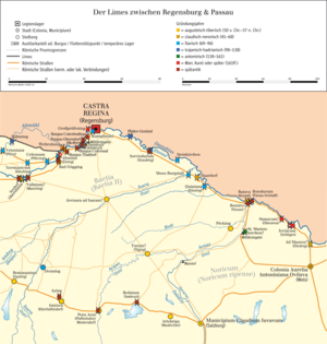
The small fort Weltenburg-Galget is an early Roman small fort in Weltenburg in the Kelheim district , Bavaria . The complex was founded on the Raetian Danube Limes in the course of the early Roman conquest in the Claudian - early Flavian times.
location
The small facility was built on the exposed northwest corner of a Jurassic mountain ridge south of the elevated site of Weltenburg-Frauenberg . The towering Frauenberg is separated from this ridge by a narrow valley depression running west-east. From the corridor “Am Galget”, both the road coming from Fort Eining at the foot of the slope and the navigable access to the Danube in a north-westerly direction into the Weltenburger Enge could be observed. To the west of the small fort, the slope first drops steeply and then gently tapering off almost 30 meters to the Danube . State road 2233 runs north in the valley floor between the small fort and the Frauenberg.
Research history
The small fort was discovered by the aerial archaeologist Otto Braasch on the basis of a completely leveled trench in the agriculturally used corridor "Am Galget". The numerous aerial photographs that were taken showed the course of three trenches bent at right angles, mostly as a positive growth feature. In a preliminary interpretation, due to the lack of found material, a Hallstatt manor was initially under discussion. After the area had been cleared for development, an emergency excavation from was the Bavarian State Conservation Office stated that from 1 April to 30 June 1989, three months, took and the county archeology Kelheim under the direction of prehistorian Michael Maria Rind performed has been. This concentrated on the northeastern part of the trench, which had remained unknown there until its investigation.
The Academic Director of the Technical University of Munich , Manfred Stephani , corrected as one of the preliminary measures for the designation of the Danube Limes as a planned world cultural heritage a particularly successful photo by the aerial archaeologist Klaus Leidorf , on which the remains of the moat, which had not yet been examined, are clearly visible. With the result of the georeferenced ortophoto, the previous monument entry could be corrected. The findings plan created in 1989 was then georeferenced by Peter Freiberger, an employee at the Bavarian State Monuments Office. A cooperation project between the University of Erlangen-Nuremberg and the Bavarian State Office for the Preservation of Monuments, led by the prehistorian Carsten Mischka , who specializes in geophysical studies , also carried out a very detailed survey with a magnetometer at the site .
Building history
The future location of the small fort was already visited by people during the springtime of the La Tène period . This is supported by two clearly delimited findings that indicate a burial site. The usable area within the small fort was around 50 × 50 meters (= around 0.2 hectares).
Containment ditch
The early Roman complex did not have moats on all sides. On the west side, towards the steeply sloping bank of the Danube, there was obviously no need for a surrounding ditch. In the south, towards the ascending slope, as well as in the east of the fortification, three parallel trenches were archaeologically accessible. Both the aerial photo and the geophysical prospection show an almost identical situation. As in the north, the triple trenching in the south is gradually being suspended. First of all, the line of the outer trench breaks off in the first third of the lowering terrain, followed by the middle trench excavation just above the flank half and finally, just before the western curve of the fort wall, the innermost artificially deepened depression. The excavator already found that shortly behind the northeast corner of the camp the two outer trenches were exposed, so that the builders apparently only allowed the inner trench to be dug on the northern flank down the slope. The cuts made on the northern flank of the fort at both outer trench heads proved this finding. Rind saw the justification of this fact in a topographical leveling that had changed since Roman times. On the contrary, recent research has shown that the original Roman topography has largely been preserved to this day. Despite this finding, Rind's investigations showed a very different state of preservation of the enclosure ditches. The strata of the backfills could be followed in the examined section down to a depth of 0.40 to 1.20 meters. At least 50 centimeters of the original loamy cover in the northeastern excavation area had been removed by soil erosion and terracing . In the excavation sections it became apparent that the gradient at the time the small fort was built could not have been as pronounced as it is today.
The bottom of the trench itself was filled with the sterile rubble of small limestone fragments, which apparently fell from the walls of the trench to the bottom of the trench shortly after the excavation. In a well-preserved location, four backfilling horizons could be documented in the inner trench, although separation was difficult due to the small differences.
Enclosure
Inside, post pits were found in the northern excavation section in particular, which followed the course of the enclosure trench at a distance of around six meters from the central axis of the inner trench. These post positions were the remains of a sod wall with wooden cladding that supported the interior of the camp and surrounded the small fort. Eight post pits that were uncovered in the northeast corner of the camp can probably be counted as one of the four wooden corner towers that once surrounded the garrison site. Exactly in the central axis of the small fort, the excavators encountered the post positions of the gate with the associated gate tower on the examined eastern flank, which in their entirety were clearly visible on the subgrade during a small follow-up examination in 1990 .
Findings and dating
The sparse found material in its entirety comprised ceramic fragments of mortars, two shards of so-called “soldiers' plates ” with Pompeian red overlay and remains of amphorae. The only fragment of glass came from a blue ribbed bowl. The main parts of the metal finds include iron nails and bronze remains, of which only a handle holder can be identified. For a more precise dating of the fort site, Rind was able to use a disc brooch with Delphinattaschen and an ace struck in Rome from the reign of Emperor Claudius (41–54). In doing so, he initially located the Roman findings in the pre-Flavian epoch, more precisely in the second third of the first century AD. Later considerations brought a date to the Claudian- early Flavian period. This means that the fortification could also have originated during the reign of Emperor Vespasian (69–79).
Monument protection
The facilities mentioned are protected as registered ground monuments within the meaning of the Bavarian Monument Protection Act (BayDSchG) . Investigations and targeted collection of finds are subject to authorization, accidental finds must be reported to the monument authorities.
literature
- Markus Gschwind , Carsten Mischka , Manfred Stephani : On the Weltenburger Enge. The early imperial small fort Weltenburg-Am Galget. In: Roland Gschlößl (Ed.): Bayerische Archäologie 3, 2019, pp. 21–22.
- Michael Maria Rind : An early imperial small fort in Weltenburg, town and district of Kelheim . In: Report of the Bayerische Bodendenkmalpflege 36/37, 1995/1996, pp. 75–112.
- Michael Maria Rind: A newly discovered early imperial fort in the Weltenburg “Am Galget” area . In: Karl Schmotz (Ed.): Lectures 9th Lower Bavarian Archaeological Conference , Deggendorf 1991, Marie Leidorf, Rahden 1991, p. 161 ff.
- Michael Maria Rind: A newly discovered small fort in the Weltenburg “Am Galget” development area. In: Michael Rind, Klaus Eisele, Thomas Fischer , Fred Mahler (eds.): 80,000 years of garbage. Archaeological research in the district of Kelheim 1986 to 1990. Marie Leidorf, Rahden 1991, ISBN 3924734623 , pp. 54–62.
- Michael Maria Rind: A newly discovered early Roman small fort in Weltenburg, Kelheim district, Lower Bavaria . In: The archaeological year in Bavaria 1989 , 1990, pp. 118–120.
- Wolfgang Czysz , Karlheinz Dietz , Hans-Jörg Kellner , Thomas Fischer : Die Römer in Bayern , Theiss, Stuttgart 1995, ISBN 3-8062-1058-6 , p. 537.
Remarks
- ↑ a b c d e f Wolfgang Czysz , Karlheinz Dietz , Hans-Jörg Kellner , Thomas Fischer : Die Römer in Bayern , Theiss, Stuttgart 1995, ISBN 3-8062-1058-6 , p. 537.
- ^ Hermann Bierl: Archeology Guide Germany. Ground monuments and museums. Wek-Verlag, Treuchtlingen, Berlin 2006, ISBN 3-934145-39-6 , p. 278.
- ↑ Sebastian Sommer : Boundaries and Connection ?! The Roman Danube Limes in Bavaria is to become a world heritage site . In: Monument Preservation Information , 170, 2019, pp. 18–20; here: p. 19.
- ↑ a b c d Michael Maria Rind : A newly discovered early Roman small fort in Weltenburg, Kelheim district, Lower Bavaria . In: The archaeological year in Bavaria 1989 , 1990, pp. 118–120; here: p. 118. The date of June 31, 1989 given in the article is incorrect because June 1989 did not have 31 days.
- ↑ a b Markus Gschwind , Carsten Mischka , Manfred Stephani : At the Weltenburger Enge. The early imperial small fort Weltenburg-Am Galget. In: Roland Gschlößl (Ed.): Bayerische Archäologie 3, 2019, pp. 21–22.
- ↑ Markus Gschwind , Carsten Mischka , Manfred Stephani : At the Weltenburger Enge. The early imperial small fort Weltenburg-Am Galget. In: Roland Gschlößl (Ed.): Bayerische Archäologie 3, 2019, p. 60 (see picture credits)
- ↑ Michael Maria Rind : Two early La Tène burials in the Weltenburg building area “Am Galget”, Kelheim community. In: Michael Rind, Klaus Eisele, Thomas Fischer , Fred Mahler (eds.): 80,000 years of garbage. Archaeological research in the Kelheim district from 1986 to 1990. , Marie Leidorf, Rahden 1991, ISBN 3924734623 , pp. 48–50.
- ↑ a b c d e Michael Maria Rind : A newly discovered early Roman small fort in Weltenburg, Kelheim district, Lower Bavaria . In: The archaeological year in Bavaria 1989 , 1990, pp. 118–120; here: p. 120.
- ↑ a b Markus Gschwind , Carsten Mischka , Manfred Stephani : At the Weltenburger Enge. The early imperial small fort Weltenburg-Am Galget. In: Roland Gschlößl (Ed.): Bayerische Archäologie 3, 2019, pp. 21–22; here: p. 22.


