Kumpfmühl fort
| Kumpfmühl fort | |
|---|---|
| limes | ORL NN ( RLK ) |
| Route (RLK) |
Raetian Limes ; Danube-Iller-Rhine-Limes |
| Dating (occupancy) | around 80 AD, by 172 AD at the latest |
| Type | Cohort fort |
| unit |
Cohors III Britannorum equitata , from 107/116: Cohors II Aquitanorum equitata |
| size | a) 2.1 ha ba) 2.1 ha bb) 2.8 ha |
| Construction | a) wood-earth b) stone |
| State of preservation | Ground monument |
| place | Regensburg - Kumpfmühl |
| Geographical location | 49 ° 0 '28.4 " N , 12 ° 5' 0.9" E |
| height | 354 m above sea level NHN |
| Previous | Großprüfening small fort (west) |
| Subsequently | Castra Regina (north) |
The Kumpfmühl fort was a Roman fort that was built around 80 AD and perished in the Marcomann Wars after 171 and at the latest around 175. Its remains lie south of the city center of Regensburg in what is now the Kumpfmühl-Ziegetsdorf-Neuprüll district .
location
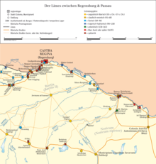
The fort was located on the edge of the terrain on the northern slope of the Königsberg, about 354 meters above sea level. In the east and west, the hill is enclosed by two valleys. The terrain rises slightly to the south in the direction of Ziegetsberg. In the eastern valley basin, the Vitusbach flows north, the course of which has not been fully clarified in Roman times. The location of the fort offered a good view of the plain about 13 meters below with the Donausüdstrasse , the Danube, the mouth of the rain and also the Roman trunk road from Augsburg , which ran towards the fort from the south , bent and immediately in front of the fort finally passed to the east, so that the most important land traffic routes as well as shipping traffic on the Danube could be well monitored from the fort.
Research history
The fort was discovered in 1924 during excavations under the direction of the State Office for Monument Preservation by G. Steinmetz and P. Reinecke , after they had previously searched systematically for a presumed predecessor of the Regensburg legion camp . In the course of three excavation campaigns in 1924, 1925 and 1927, it was finally located by the local excavation manager A. Langsdorff using narrow search trenches. The defensive wall, the pointed trenches and the western camp entrance were recorded. With the exception of emergency rescues, no archaeological investigations were carried out at Kumpfmühl fort until the 1980s. Further excavations followed in 1982. Large area excavations were never carried out in the Kumpfmühl fort due to the modern development. The previous research in Kumpfmühl was finally edited by Andrea Faber and published in 1994 as part of a dissertation. Subsequent excavations in the 1990s finally provided evidence that the fort in its final construction phase extended 45 meters further to the west, so that the Kumpfmühl treasure trove was not hidden in the vicus as previously assumed , but in the fort itself.
Fort
In the course of the Roman occupation of the country up to the Danube ( Raetia province ), a fort was set up around the years 79/81, which covered the border on the Danube. Its name in Roman times is not known. Like other structures, it was originally designed as a wood-earth structure and was expanded in stone in the Trajanic - Early Hadrian period and expanded from 2.1 to 2.8 hectares as part of a second stone construction period in the late 120s or 130s.
Timber construction phase
Since it is overlaid by the first stone construction phase, hardly anything has been preserved from the wooden construction phase. Only three post holes from the west and north side of the fort can be safely assigned to the timber construction. They lay below the remains of the foundations of the later stone wall. Other wood findings on the west side, which were previously interpreted as part of the fort's defense, can no longer be clearly assigned to this. Since a large part of the findings researched in the 1920s cannot be classified chronologically, they could also have been part of the interior development after the fort was expanded. It is not certain whether the fort already had two weir ditches in the timber construction phase. Only the inside is proven. No findings can be reliably assigned to the interior structures of the timber construction period.
Stone construction phase 1
At the latest from the first stone construction phase, the fort was surrounded by two weir ditches. The wood-earth fence was replaced on the spot by a stone wall, which has been proven all around. Remnants of the north-western corner tower were recorded on the west side of the camp. In the timber construction phase and in the first stone construction period, the fort had an internal area of approx. 2.1 hectares (153 × 139 m).
Stone construction phase 2
In the second stone construction period, the fort was extended by approx. 45 m to the west to an area of 2.8 hectares (153 × 184 m). In the course of this, the two trenches in the west were filled with the fragments of the western fort wall. Reusable material was removed and used to expand the fort wall.
There is hardly any evidence of the interior of the fort for the stone construction phases either. Most of the findings can neither be determined functionally nor chronologically. A wall corner in the center of the fort may have belonged to the vestibule of an east-facing principia in the second stone construction phase. The second stone construction phase also includes two cellars, which, however, cannot be classified functionally.
Vicus
In the east and south of the military facility, a civil settlement ( vicus ) with houses made of wood and stone ( strip houses ) and the usual buildings such as rest house ( mansio ) and fort baths arose on an area of approx. 20 hectares . There were brickworks, pottery and metalworking workshops. As usual, grave fields were laid out on the arterial roads. The largest Roman cemetery in Germany was discovered on the railway site in the north, in which the tombstone of a Sarmannina was also found. With the date around 400 AD, it is the oldest witnessed Christian in Raetia . At the same time, another settlement was built 1.5 km further north, on the right bank of the Danube, which presumably belonged to another fort, of which nothing has yet been found because it was later built over by the civilian area of the legionary camp ( Canabae legionis ).
The end of the Roman Kumpfmühl
The fort as well as the civil settlement went under in the Marcomann Wars (166–180 AD). According to the finds, the destruction took place between 171 and 175. After the Marcomann Wars, the fort was not rebuilt. Reusable building material was later systematically removed and used in the construction of the Regensburg legion camp . After the destruction of the fort, only isolated traces of settlement can be found in the vicus , which probably belong to villae rusticae .
Troop
As evidenced by inscriptions and brick stamps , the fort was occupied by changing auxiliary units , of which the Cohors III Britannorum equitata (3rd partially mounted cohort of the British) and the Cohors II Aquitanorum equitata , which was moved from the Upper Germanic fort in Arnsburg to Raetia between 107 and 116 (2nd partially mounted cohort of the Aquitaine) are known, units of almost 500 men, about a quarter of which consisted of cavalry. It is believed that the Aquitanians stayed there until the fort was destroyed in the Marcomann Wars. It is possible that this unit subsequently expanded the Dambach fort .
A brick stamp of the Cohors III Thracum civium Romanorum equitata to torquata discovered in Kumpfmühl probably got there alone or with a construction department of the manufacturer for reasons that are no longer comprehensible today. Until the first decades of the 2nd century the Thracians lay in the Danube fort Künzing to the south .
The treasure of Kumpfmühl
In 1989, during construction work in the west of the former fort, a deposit was uncovered, the largest of coins in southern Germany.
In total, the find includes:
- a bronze cauldron in which the other items had been carefully stowed
- four heavy golden finger rings
- two gold pendants, wheel-shaped or crescent-shaped
- a silver miniature vessel
- two silver necklaces
- a pair of bracelets made of sheet silver
- a pair of silver piston arm rings
- a pair of wing brooches made of silver-plated bronze sheet, origin: Noricum-Pannonia
- Coins: 25 aurei , 610 denarii, two aces, one quadrans
It is evidently a family treasure, such as that of an officer and his wife - a prime example of a Roman find hidden: valuable personal property (money and jewelry) was carefully, not in a panic, hidden within the fortifications, apparently as a long-term security.
As usual, dating by means of coins is possible, while small ceramic fragments do not allow any further definition. The final coin represents eight of the same type, even largely identical to the stamp, from Emperor Marcus Aurelius from 166 denarii, received fresh from the mint . They apparently never circulated, but "got into the ground pretty much as soon as 166 was issued". Given the nature of the security, the destruction of the fort need not have followed immediately.
Monument protection
The Kumpfmühl fort and the facilities mentioned are protected as registered ground monuments within the meaning of the Bavarian Monument Protection Act (BayDSchG). Investigations and targeted collection of finds are subject to authorization, accidental finds must be reported to the monument authorities.
See also
literature
- Dietwulf Baatz : The Roman Limes. Archaeological excursions between the Rhine and the Danube. 4th edition, Gebr. Mann, Berlin 2000, ISBN 3-786-12347-0 , p. 327 f.
- Andreas Boos , Lutz-Michael Dallmeier, Bernhard Overbeck : The Roman treasure of Regensburg-Kumpfmühl. Museums of the City of Regensburg, Regensburg 2000, ISBN 3-925753-86-9 .
- Karlheinz Dietz , Thomas Fischer : The Romans in Regensburg. Pustet, Regensburg 1996, ISBN 3791714848 , pp. 43-65.
- Andrea Faber: The Roman auxiliary fort and the vicus of Regensburg-Kumpfmühl. Beck, Munich 1994, ISBN 3-406-35642-7 (Munich contributions to prehistory and early history 49).
- Thomas Fischer , Regensburg-Kumpfmühl. In: Wolfgang Czysz u. a .: The Romans in Bavaria. Theiss, Stuttgart 1995, ISBN 3-8062-1058-6 , p. 503.
- S. Sandbichler, New Investigations in the Middle Imperial Auxiliary Fort Regensburg-Kumpfmühl. Beck, Munich 2009, ISBN 978-3-406-11078-8 (Bavarian prehistory sheets 74) pp. 39-130.
Remarks
- ↑ " Sarmaninnae ... martiribus sociatae "; Image of the tombstone by Thomas Fischer p. 384
- ↑ Faber, p. 244
- ↑ Nicole Lambert, Jörg Scheuerbrandt : The military diploma: source for the Roman army and documents. Konrad Theiss Verlag, Stuttgart 2002. ISBN 3806217262 . P. 54.
- ^ Peter Schmid (ed.): History of the city of Regensburg. Volume 1. Verlag Friedrich Pustet, Regensburg 2000. ISBN 3791716824 . P. 21.
- ↑ Overbeck, p. 65

