
Stake village
Pfahldorf is part of the municipality and a district of the Kipfenberg market in the Upper Bavarian district of Eichstätt .

geography
The church village is located in the Altmühltal Nature Park on the Jura plateau northwest of Kipfenberg at approx. 505 meters above sea level .
Transport links
From the village on the Jura high road Eichstätt - Kinding , connecting roads lead to Kipfenberg, Gungolding and via Hirnstetten , Altdorf , Emsing to Greding .
history
Barrows from the Bronze Age have been found south of Pfahldorf. The place name indicates that the village is located on the former Roman border wall " Upper Germanic-Raetian Limes ", which existed until the 3rd century AD and is still a low wall northwest of Pfahldorf with the two watchtowers Wp. 14 / 72 and 73 or shows as a dirt road.
Pfahldorf is mentioned for the first time in 820 when Siegfried, Abbot of Engelbrechtsmünster , gave away goods to the Sankt Emmeram monastery in Regensburg. In 891 King Arnulf of Carinthia gave the Eichstätter bishop property in Pfahldorf. In the dispute over the "Hirschberg Inheritance" the place was assigned to the Hochstift Eichstätt in 1305 after the bishop had already bought an estate in Pfahldorf from the last Hirschberg Count Gebhard VII in 1302 . In 1370 the Lords of Brunneck owned goods here in the Anlautertal ; Pfahldorf is recorded in the Salbuch of the Episcopal Office of Brunneck, created around 1747 .
During the witch hunt in the Eichstätt monastery , at least one woman from Pfahldorf was accused of being an alleged witch and sentenced to death in 1613.
The land consolidation from 1968 should be mentioned more recently . On January 1, 1972, the place came to market Kipfenberg as part of the regional reform . The population is 440 (March 7, 2016).
Economy and Infrastructure
Pfahldorf has two restaurants, one with an attached hotel, and several commercial operations. There is a kindergarten in the village .
Parish Church of St. John Baptist
The village has been a Catholic parish since 1752; In 2007 the parish had 389 Catholics. There is no news about the previous building ( fortified church Pfahldorf ) of today's parish church in the center of the village in a somewhat elevated position; Only the tower from the 14th century and the cemetery wall have survived from the medieval complex. In 1469, the Eichstatt Bishop Wilhelm von Reichenau approved an early knife; at that time Pfahldorf belonged to the parish Gungolding. In 1492 a Steffan Schnitzer donated a light for the poor at the cemetery chapel.
The tower was repaired by a bricklayer from Eichstatt towards the end of the 17th century; the green, yellow and gray blue glazed Daschen the tower helmet was provided by the Hafner Andreas Sander. Today's church was built in 1760/61 by rebuilding the nave while retaining the tower , by the Kipfenberg bricklayer Michael Haberl according to plans by the Eichstätter cathedral master builder Giovanni Domenico Barbieri . This new building was furnished in the baroque style of the time and consecrated in 1792 .
The choir is located in the east tower and has a baroque flat ceiling. The nave is also flat, the windows are arched. The choir and nave have decorative ceiling paintings on the life and work of the church patron. Among other things, they depict the baptism of Christ and the beheading of John the Baptist. According to the inscription, they were painted in 1760.
Instead of the altarpiece, a late Gothic figure of the patron saint of the church is placed, which comes from the secularized Augustinian canon monastery Rebdorf and is considered an "excellent creation around 1510" (Felix Mader). The two-column side altars were erected in 1761. In the side altars there is a figure of St. Andrew on the right and a Maria with the child on the left. The pulpit is baroque, around 1700, and has a polygonal body with corner pillars; the pictures on it are more recent.
The sacristy is attached to the south side of the choir. A gate tower of the churchyard fortified in the Middle Ages, mentioned in 1601/02, no longer exists. A late Gothic Johannes bowl from the middle of the 15th century with colored tendrils from the 17th century, which Felix Mader (p. 255) shows, is no longer in the church.
In 1832 the church tower was partially demolished and rebuilt, but eight meters lower.

St. John Baptist Church

Chancel of the Johannes Baptist Church

Church organ
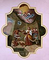
Ceiling painting - beheading of Johannes Baptist


Others
- The “Birnhoftanne”, a white fir (Abies alba), is a mighty solitaire near Pfahldorf .
- In 1996 a 16–17 million year old tusk of the elephant species Dinotherium bavaricum was found northwest of Pfahldorf; In the Pfahldorf area there are limescale deposits from lake sediments of the older freshwater molasses .
- The German Limes Cycle Route runs through the village . It follows the Upper German-Raetian Limes over 818 km from Bad Hönningen on the Rhine to Regensburg on the Danube .
- The Limes hiking trail touches the northern outskirts of Pfahldorf.
societies
The following associations operate in Pfahldorf: horticultural association, warrior and military association, girls and boys association, rifle association "Jurahöhe" with its own rifle house and volunteer fire brigade .
Personalities
- Franz Xaver Bovius , manufacturer of sundials, 1718–23 early knife and parish curate in Pfahldorf
- Michael Hot , 1818–1890, Archbishop of Milwaukee / USA, born in Pfahldorf
literature
- Hans Baier and others (editor): The Eichstätter space in the past and present . Eichstätt 1973: Stadt- und Kreissparkasse, pp. 245–247 (with bibliography)
- Johann Kaspar Bundschuh : Pfahldorf . In: Geographical Statistical-Topographical Lexicon of Franconia . tape 4 : Ni-R . Verlag der Stettinische Buchhandlung, Ulm 1801, DNB 790364301 , OCLC 833753101 , Sp. 333-334 ( digitized version ).
- Elmar Ettle: Festschrift Schützenverein Jurahöhe Pfahldorf. 25th anniversary. Pfahldorf 1979
- Felix Mader (editor): The art monuments of Bavaria. Middle Franconia. II. Eichstätt District Office , Munich 1928, reprint 1982, pp. 254–255, see [1]
- Pleikard Joseph Stumpf : Pfahldorf . In: Bavaria: a geographical-statistical-historical handbook of the kingdom; for the Bavarian people . Second part. Munich 1853, p. 737 ( digitized version ).
- Karl Zecherle: Churches and monasteries in the Eichstätt district . Eichstätt 1983: District, p. 50f.
Web links
Individual evidence
- ^ Wilhelm Volkert (ed.): Handbook of Bavarian offices, communities and courts 1799–1980 . CH Beck, Munich 1983, ISBN 3-406-09669-7 , p. 456 .

Arnsberg | Attenzell | Biberg | Birch stalks mill | Boehming | Böllermühle | Book | Dunsdorf | Grösdorf | Hirnstetten | Irlahüll | Kemathen | Kipfenberg | Krut | Oberemmendorf | Pfahldorf | Regelmannsbrunn | Schambach | Schelldorf | Castle courtyard
Coordinates: 48 ° 58 ' N , 11 ° 20' E