Irlahüll
|
Irlahüll
Kipfenberg market
Coordinates: 48 ° 58 ′ 25 ″ N , 11 ° 25 ′ 20 ″ E
|
|
|---|---|
| Height : | 527 (521-532) m |
| Residents : | 245 (March 7, 2016) |
| Incorporation : | April 1, 1971 |
| Postal code : | 85110 |
| Area code : | 08465 |
Irlahüll is a district of the Kipfenberg market in the Upper Bavarian district of Eichstätt in the Altmühltal Nature Park .
location
The village is located on the plateau of the southern Franconian Jura, northeast of the municipality of Kipfenberg and east of the A 9 federal motorway. It can be reached from the Altmühltal via a junction on state road 2230 in Kipfenberg- Kemathen . Local roads lead from Irlahüll to the Kipfenberg districts of Buch (district road EI 22) and Oberemmendorf .
history
The place "Erlinhul" (= Hüll with alder trees or Hüll des Erluin) is an old property of the Eichstätter Church. The place is mentioned for the first time in connection with a fiefdom of two farms and the tithe to Count Bertold von Graisbach in 1265. At the latest when the Graisbachers died out in 1327, these fiefs fell back to the bishop; Possibly they are identical to the two goods that Provost Ulrich von Spalt gave in 1308 to the foundation of the Vicarie St. Elisabeth at Eichstätter Dom. The Absbergers in Rumburg also had fiefdoms in Irlahüll ; In 1447 it consisted of eight estates that were vogtable to Hirschberg . They owned another one at that time. In 1546 the Absberger Lehenhöfe fell back to the bishopric ; as early as 1398, Bishop Friedrich IV. the Schweiger (Sweygger) of Gundelfingen bought Irlahüller farms, which originally belonged to the Franconian royal court of Greding . Around the middle of the 15th century the Wildensteiner Feldlehen held, in 1644 the Muggenthaler had fiefs on individual pieces. In 1561 the bishop bought the tithe. In 1602 the village consisted of 24 houses. It is recorded for 1644 that the main episcopal estates in Irlahüll amounted to eight.
In addition to the aristocratic and episcopal estates, there were other properties in Irlahüll. The Augustinian Canons' monastery Rebdorf owned a farm, which, however, had already come into the possession of the bishops around 1518. In Eichstätt the cathedral chapter owned two Irlahüller estates until the secularization of 1802, individual items belonged to the Dominican monastery in Eichstätt , the bell mass in the cathedral and a hop garden of the Kollegiata. The churches in Kinding and Irlahüll received taxes. In addition, there was a lot of peasant property; In 1741, the Laurer, Löhlein, Öttinger, Regensburger, Schmid, Flierle and Weber families were named among a total of 177 villagers. Irlahüll belonged to the secularization along with seven other places for marriage detention Irfersdorf and box office Beilngries the Oberamt Beilngries-Hirschberg.
During the secularization, the lower bishopric, in which the caste office of Beilngries and thus also Irlahüll was located, came to the Grand Duke Archduke Ferdinand III. of Tuscany . In 1806 the Kingdom of Bavaria received the area; Irlahüll was now part of the Kipfenberg district court. In the ducal Leuchtenberg principality of Eichstätt (1817–1833), the village, which consisted of 32 houses with around 150 residents, remained with the Kipfenberg rulership.
1808 formed Irlahüll with book and Gelbelsee the control district Gelbelsee in Altmühl District ; In 1818 the places became independent communities again.
During the Bavarian territorial reform , Irlahüll joined on April 1, 1971 as a district of the market Kipfenberg in the district of Eichstätt. On July 1, 1972, as part of the district reform, the change from Middle Franconia to Upper Bavaria took place .
In 1808 the population was 153 and in 1939 183. In 1959 there was a land consolidation . In 1983 there were twelve full-time agricultural businesses and 16 part-time businesses and a few handicraft businesses in the village with 193 inhabitants. The site is crossed by the more than seven kilometer long ICE - Irlahell Tunnel, the construction of which created cavities as karst phenomena of the Jura, causing considerable problems.
Catholic Parish Irlahüll
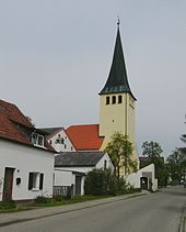
In the Middle Ages, Irlahüll was a branch of Irfersdorf , temporarily of Kinding . In the late Gothic period , the church was rebuilt in 1466 except for the tower. In 1767 the independent pastoral care office (curate beneficiary) "Irrlahhüll" was donated by the Grösdorfer water miller . In 1848 (not 1846!) The elevation to parish took place. Today the parish (2007: 211 Catholics) as well as the Irlahüller branch St. Sebastian in Buch (2007: 145 Catholics) receive pastoral care from Gelbelsee. The church patronage is the Visitation of the Virgin Mary .
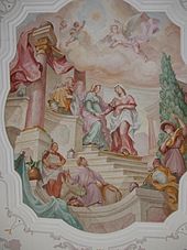
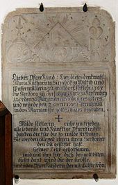
While the church tower with its eight-sided pointed helmet still has Romanesque masonry, today's nave is a baroque building , probably from 1742, which was consecrated in 1752. In any case, the nave was probably stuccoed by Franz Xaver Horneis in 1742 and the three four-column altars came into the church. In 1852 the church was expanded to the west; the ceiling painting is by Sebastian Wirsching from the year 1880. The baroque high altar is adorned with a “remarkable” (Mader, Hirschberg, p. 183) figure of Mary from the late Gothic period (circa 1470–1480); to the side are St. Peter and Paul (around 1500). The side altars have Nazarene altarpieces. The coat of arms of Prince-Bishop Johann Anton II von Freyberg , during whose reign the church was rebuilt or baroque, is placed above the choir arch . The Jura tombstone of the donor Maria Katharina Sinaböck († 1787) von Grösdorf is embedded in the nave wall of the left side altar. On the war memorial you can find the tympanum of a sacrament niche with the man of Sorrows as a half-figure, created around 1530/50 by the workshop of Loy Hering .
societies
- Voluntary fire brigade , founded in 1895
Individual evidence
- ^ Wilhelm Volkert (ed.): Handbook of Bavarian offices, communities and courts 1799–1980 . CH Beck, Munich 1983, ISBN 3-406-09669-7 , p. 456 .
literature
- Felix Mader (editor): The art monuments of Middle Franconia. II Eichstätt District Office. Munich: R. Oldenbourg Verlag 1928 (reprint 1982), pp. 152-154
- Felix Mader: History of the castle and Oberamt Hirschberg. Eichstätt: Brönner & Daentler 1940, p. 182f.
- The Eichstätter area past and present. 2nd Edition. Eichstätt: Sparkasse Eichstätt 1984, p. 217f.
- Gerhard Hirschmann: Eichstätt, Beilngries-Eichstätt-Greding . In: Commission for Bavarian State History at the Bavarian Academy of Sciences (Hrsg.): Historical Atlas of Bavaria . Part Franconia, Series I, Issue 6. Munich 1959 ( digitized version )
- Wolfgang Wiessner: Hilpoltstein . In: Commission for Bavarian State History at the Bavarian Academy of Sciences (Hrsg.): Historical Atlas of Bavaria . Part Franconia, Series I, Issue 24. Munich 1978, ISBN 3-7696-9908-4 ( digitized version ).
- B. Maidl: Solving karst problems - using the example of the Irlahll tunnel on the new DB line Nuremberg – Ingolstadt . In: Bautechnik, August 2006
Web links
- Photos of Irlahüll and book on the website of the district of Eichstätt
- Bells and photos of the church


