
Irlahüll tunnel
| Irlahüll tunnel | ||||
|---|---|---|---|---|
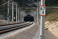
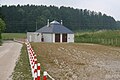
 North portal with ICE 1
|
||||
| traffic connection | New Nuremberg – Ingolstadt line | |||
| length | 7260 m | |||
| Number of tubes | 1 | |||
| cross-section | up to approx. 146 m² | |||
| construction | ||||
| Client | Deutsche Bahn | |||
| building-costs | approx. 130 million euros | |||
| start of building | March 1999 (main drive) | |||
| business | ||||
| operator | DB network | |||
| release | 2006 | |||
| location | ||||
|
||||
| Coordinates | ||||
| North portal | 48 ° 59 ′ 16 ″ N , 11 ° 23 ′ 7 ″ E | |||
| South portal | 48 ° 56 ′ 27 ″ N , 11 ° 27 ′ 12 ″ E | |||

The Irlahll Tunnel (formerly also: Altmühltunnel ) is, with its length of 7,260 meters, the second longest railway tunnel on the high-speed line Nuremberg – Ingolstadt – Munich after the Euerwangtunnel . It got its name from the town of Irlahüll (part of the municipality of Kipfenberg ), which the tunnel passes under. The tube accommodates two tracks in slab track , which can be driven on as planned at a speed of up to 300 km / h.
course
In the tunnel, the route rises in a north-south direction over a length of 6.2 kilometers with an 18 ‰ gradient by 115 meters in altitude - from around 380 to around 500 meters. The tube runs largely straight, near the north portal a curve was laid in a north-westerly direction.

In the area of the north portal, the tunnel crosses under federal motorway 9 . Next to the Stammham tunnel, it is the second crossing under the trunk road. Immediately to the north is the Kinding regional train station (Altmühltal) with the Altmühltal bridge. A special feature are the platform tracks, which branch off from the two main tracks at points in the northern tunnel portal. The Denkendorf substation , one of two substations on the high-speed line, is located near the south portal .
Due to the steep incline, trains in the direction of Ingolstadt / Munich are generally unable to maintain their maximum speeds. For example, an ICE 3 entering the north portal at 300 km / h leaves the upper (southern) portal at “only” around 270 km / h , even with maximum traction . Trains traveling in the direction of Nuremberg, on the other hand, usually reach their top speed for the first time in "Irlahüll" (on the ICE 3: 300 km / h).
Geology and hydrology
The tunnel runs almost entirely in layers of the White Jura . Quaternary layers are passed through in the area of the north portal and tertiary layers at the south portal . Over a length of 5.4 km (planning status from 1999), massive dolomite and limestone is traversed, which already indicated pronounced karstification in the planning phase.
The water table in the northern half of the tunnel is largely above the structure, in the southern section the structure is above it.
history
background
In a confidential report by the Bavarian State Office for Environmental Protection comparing the Ingolstadt and Augsburg variants, the authority spoke out against the Ingolstadt variant in mid-1990, among other things because of serious interventions in the Anlauter and Altmühltal valleys. The Irlahüll tunnel was planned with a length of 7.1 km.
planning
The structure was part of the plan approval section 53 of the new line. It was part of the 18.4 km long and 327 million euro (status: 1999) construction lot in the middle of the new line, which the Hochtief company was commissioned to implement.
At the beginning of the 1990s, the tunnel with a length of 7170 m was planned. In mid-1994 the tunnel was planned with a length of 7260 m and a longitudinal incline of up to 20 per thousand. In autumn 1995 construction of the main tunnel was expected to begin in spring 1996 and its commercial commissioning in 2002.
The structure was planned as early as 1999 with a length of 7260 m, which was realized later.
The construction period was planned from 1998 to 2002.
construction
The single-tube tunnel was built using the shotcrete method of mining.
In mid-October 1995 a geological exploratory tunnel was driven around 100 m. The daily advance was around 5 m. The 610 m long gallery meets the driving tunnel at a right angle and was completed in mid-1999. The building now serves as an emergency exit 4.
The first preparatory demolition took place at the end of November 1998. From March 1999, the tunnel was driven from the exploratory tunnel in both directions. Starting in May of the same year, a pre-cut was built on the south portal, and one month later also on the north. The north portal was built using the cut-and-cover method, the subsequent undercutting of the A9 was carried out using an elm tunnel.
Roswitha Wiesheu, the wife of the then Bavarian Minister of Economics and Transport, Otto Wiesheu , acted as tunnel sponsor .
The mining operation took place from mid-June 1999 in the south and from mid-October in the north. The breakthrough between the intermediate attack (emergency exit 4) and the northern section took place in mid-July and in the southern section on November 13, 2000.
The symbolic start of construction was celebrated on September 21, 1999. The construction work should be completed in early 2003. Up until the end of March 2000, the tunneling showed that the location and structure of the karstification exceeded the data forecast in the previous geological exploration programs. In the course of the construction work there was also at least one daybreak on the surface of the site.
At the end of March 2000, a 52-year-old worker had a fatal accident when he walked into the tunnel and was hit by a dump truck about 250 m from the portal .
During the tunneling work, the location, the structure of the karstifications and the dimensions of the cavities connected to them proved to be larger than expected on the basis of the previous geological exploration programs. In 2000 the construction companies pointed out that the mountain structures found were not as load-bearing as assumed.
The attacks on the northern emergency exits 1 (385 m) and 2 (745 m) began in July and August 1999. The drive in the south area was completed at the end of 2000. Karst restoration began in December 2000.
The delays as a result of the geological problems are considered to be the main reason for the delayed commissioning of the line. In mid-2001 it was already foreseeable that the commercial commissioning of the line, which was officially planned for 2003 at the time, could not be adhered to. Auditors commissioned by Deutsche Bahn came to the conclusion that the calculation had been nicely calculated and the schedule had been far too optimistic.
Around 944,000 m³ of material was excavated for the tunnel, and around 365,000 m³ of concrete and 8,800 t of reinforcing steel were installed.

Construction work on the north portal (around 2000)

South portal with earthworks in the transition to the Denkendorf tunnel (2001)

The north portal during the construction phase in 2003


Karst problem
The Irlahell Tunnel leads through approx. 5.5 kilometers of karst-sensitive limestone. The karst formation of the Jurassic limestone was much more pronounced and more common in this area than the preliminary explorations had suggested. In the course of the drive, karst caves were repeatedly encountered. At one point, cave explorers were used, who rappelled into a karst cavity 48 m below the bottom of the dome and there came across an underground stream.
During the drive, 18 larger karst structures were approached. The cavities found ranged in size from 10 to several hundred cubic meters. Seven cavities were opened, the remaining eleven at least partially filled. For stabilizing injections , 13,000 meters of drilling with around 25,000 m³ of grout was used. Concrete seals were also used to permanently secure the tunnel's statics.
The karst problem led to considerable delays in construction times and cost increases. The associated special constructions for the inner shell and the driveway were particularly complex. In addition to the Irlahell tunnel, there were also problems with karstification during the construction of the Stammham and Geisberg tunnels .
Critics complain that a strong karstification of the mountains was to be expected and therefore a comprehensive evaluation of experiences and preliminary exploration would have been necessary before the start of the construction work. For example, the experience of the incomparably more intensive building site investigation of the new Wendlingen – Ulm line was presented in 1991. An exploratory tunnel at the Irlahüll tunnel would have been indispensable.

View into the tunnel in north direction at the south portal. The lighting makes the long, descending route visible
Section in front of the south portal
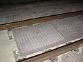
Sound absorbers on slab tracks

Steel planks (LARS) to protect against falling parts of the load on the north portal


Commissioning and operation
At the Irlahüll and Euerwang tunnels, the tunnel bang was observed during test drives in 2005, for the first time in Germany . As a countermeasure, porous, corrugated sound absorber plates were attached between the rails. Despite this measure, a slight bang in the tunnel can be heard on the south portal of ICE 3 trains traveling at 300 km / h.
A rescue drill took place in the tunnel in mid-July 2010. The collision of an ICE 3 with about 85 people with an object was simulated.
Due to the highly calcareous water in the vicinity of the tunnel, constant flushing and checking of the drainage is necessary. For this purpose a night drives on a regular two-way vehicle the Western Railway.
security concept
The structure is equipped with nine emergency exits that lead into three tunnels and two (vertical) shafts .
The emergency exits in detail:
- The northernmost emergency exit 1 leads at route km 60.594 after a 12 m long corridor with a lock over a 385 m long accessible gallery in a south-westerly direction out of the tunnel. The tube comes to the surface at 48 ° 58 ′ 46.1 ″ N , 11 ° 23 ′ 33.2 ″ E , on the connecting road between Kinding and Kemathen (part of the municipality of Kipfenberg )
- Further south on the same road, Emergency Exit 2 comes to the surface at 48 ° 58 ′ 32.1 ″ N , 11 ° 23 ′ 45.2 ″ E. Leaving the tunnel at km 61.564, a passable tunnel of 745 m in length leads out of the tube in a north-westerly direction. There is also a 12 m long lock upstream.
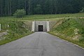
- The emergency exits 3a (km 62.564), 3b (km 62.964) and 4 (km 63.589) are connected to each other via a drivable parallel gallery of 1019 m length running parallel to the driving tunnel to the west; two locks are installed in the gallery. Near emergency exit four, a 560 m long drivable tunnel leads to the surface at 48 ° 57 ′ 31 ″ N , 11 ° 25 ′ 12 ″ E on the road between Kipfenberg and Buch (part of this municipality) west of the A 9.
- Exit 5a (km 64.562) to the north and 5b (km 64.687) to the south are connected to each other by a 138 m long walk-through gallery running parallel to the tunnel to the east. At the level of exit 5a, a 49 m high round shaft with a diameter of 8.0 m leads to the surface. The surface is reached at 48 ° 57 '23.5 " N , 11 ° 26' 1.8" E between Gelbelsee and Buch (Kipfenberg municipality).
- The two southernmost exits from the tunnel, 6a (65.687 km) and 6b (65.824 km), are connected to each other by a 150 m long walkable tunnel running east parallel to the tube. At the level of exit 6a, a round shaft 34 m high and 8.0 m in diameter at 48 ° 56 '55.5 " N , 11 ° 26' 37.1" E on the outskirts of Gelbelsee leads to the surface.
The two shafts were equipped with an elevator due to their height of over 30 m . Including the parallel tunnels, a total of 2,960 meters of rescue tunnels were created.

Emergency exit 1 with rescue area
Emergency exit 2
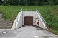
Access to the rescue tunnel of emergency exits 3a, 3b and 4
Emergency exit building of emergency exits 5a and 5b with an emergency rescue area in front

Emergency exit building of emergency exits 6a and 6b


A street leads over the north portal. To protect against falling parts of the load from trucks, three-meter-high steel planks were erected in addition to crash barriers (so-called load-dropping-restraint system , LARS ). The safety lighting is switched off in normal operation.
See also: Route safety concept
costs
The construction costs are given in a source with about 100 million euros net. Another source puts the construction costs at 260 million D-Marks (around 132 million euros).
The provisional order value for the entire 18.35 km long central lot was given around 1999 at 638 million DM or 327 million euros.
The costs for the exploratory tunnel were initially estimated at seven and a half million DM and, due to the favorable bearing properties of the surrounding mountains, were estimated at six million DM in October 1995.
The Federal Government is not aware of the costs of the tunnel construction.
See also
Web links
- Irlahüll tunnel. In: Structurae
- Ground investigation for traffic routes in karst areas (pdf, 4.18 MB)
Individual evidence
- ↑ a b c d e f g h Bernhard Maidl, Ulrich Maidl: Solving karst problems using the example of the Irlahll tunnel on the new DB line Nuremberg – Ingolstadt . In: Bautechnik , Volume 83 (2006), Issue 8, pp. 525-532, doi: 10.1002 / bate.200610045 .
- ↑ Residents stay on the opposite course . In: Ingolstädter Zeitung , July 28, 1989.
- ↑ a b Günter Strappler, Heinz-Dieter Könnings: New Nuremberg - Ingolstadt sticking points in the settlement of tunnel projects . In: Rock Engineering , ISSN 0174-6979 , Vol 17 (1999), No. 5, pp 358-366...
- ↑ Wolfgang Krach: "Irreversible damage caused by the ICE" . In: Donaukurier . No. 183 , August 10, 1990, ZDB -ID 1477609-1 , p. 4 .
- ↑ a b Hochtief: Annual Report 1999 , p. 47.
- ↑ Kilometers of tunnels . In: Roth-Hilpoltsteiner Volkszeitung . June 5, 1991, ZDB ID 1264431-6 .
- ^ Deutsche Bahn, Network Division, Regional Area Nuremberg (ed.): New Nuremberg – Ingolstadt line . 12-page brochure dated July 1994, p. 6.
- ↑ a b c Astrid Pfeiffer: The way is being prepared for a new ICE route . In: Süddeutsche Zeitung , regional edition Bavaria, July 4, 1996, p. 46.
- ^ Planungsgesellschaft Bahnbau Deutsche Einheit mbH (Ed.): Nuremberg – Munich in one hour . Nuremberg, November 30, 1999 (similar version from January 1999 as PDF file , 2.3 MB), p. 9.
- ↑ Thomas Pfaffe: The tunnel builders are already at work . In: Süddeutsche Zeitung , October 24, 1995, p. 42.
- ↑ Peter Milian: Between Greding, Kinding and Denkendorf are the longest tunnels on the new ICE line to Ingolstadt . In: Nürnberger Nachrichten , July 24, 2000.
- ^ New ICE and upgraded Nuremberg - Munich line - status of construction work in June 2005 Information sheet from DB ProjektBau, Nuremberg.
- ↑ The day in the Free State . In: Passauer Neue Presse , September 22, 1999.
- ↑ Jens Böhlke, Klaus Müller: Railway tunnel construction in karst areas - required safety certificates and their treatment by the Federal Railway Authority . In: Study Society for Underground Transport Systems (Ed.): Tunnel - Lifelines of the Mobile Society (= Research + Practice ). tape 40 . Bauverlag, Gütersloh 2003, ISBN 3-7625-3602-3 , p. 67-73 .
- ↑ Death in the ICE tunnel . In: Nürnberger Nachrichten , March 27, 2000.
- ↑ Jens Böhlke, Klaus Müller: Railway tunnel construction in karst areas - experience with the construction of the new DB line Nuremberg - Ingolstadt . In: Bauingenieur , ISSN 0005-6650 , Volume 79, June 2004, pp. 264-271.
- ↑ a b Peter Millian: On the new ICE line between Nuremberg and Ingolstadt, tunnel construction is increasingly becoming an incalculable risk . In: Nürnberger Nachrichten , July 9, 2001.
- ↑ Peter Millian: Nothing is too expensive for the railway for Tempo 330 . In: Nürnberger Nachrichten , August 31, 2001.
- ↑ a b Hochtief Civil (Ed.): Your path is our goal. Nuremberg - Ingolstadt in 30 minutes. 12-page brochure, Munich, approx. 1999, p. 12.
- ↑ Peter Wegerer: Coping with the karst problem at the Nuremberg – Ingolstadt new line . In: Eisenbahntechnische Rundschau , 52 (2003), Edition 4, pp. 182–191.
- ↑ JR Kriehl: Communications . In: Bautechnik , Volume 84 (2007), Issue 1, p. 82 f.
- ↑ G. Brux: Tunnel Bang: Origin and Countermeasures . In: Bautechnik , issue 10/2011, p. 731 f. doi: 10.1002 / bate.201101504 .
- ↑ Viktoria Großmann: Disaster deployment 34 meters underground . In: Süddeutsche Zeitung , July 19, 2010, regional section Bavaria, p. 46.
- ↑ Project description of the Irlahll Tunnel ( Memento from September 29, 2007 in the Internet Archive ) Laabmayr & Partner.
- ↑ German Bundestag (ed.): Answer of the Federal Government to the minor question from the deputies Harald Ebner, Dr. Valerie Wilms, Sylvia Kotting-Uhl, other MPs and the parliamentary group BÜNDNIS 90 / DIE GRÜNEN - Printed matter 17/12357: Cost development of the new Wendlingen – Ulm line . Printed matter 17/12656. March 11, 2013, ISSN 0722-8333 , p. 4 f . ( bundestag.de [PDF]).