
Euerwangtunnel
|
Euerwangtunnel Euerwang tunnel
|
||||
|---|---|---|---|---|
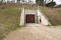
 South portal of the Euerwangtunnel
|
||||
| use | Railway tunnel | |||
| traffic connection | New Nuremberg – Ingolstadt line | |||
| place | Greding | |||
| length | 7700 m | |||
| Number of tubes | 1 | |||
| cross-section | to 146.0 | |||
| Largest coverage | 190 m | |||
| construction | ||||
| Client | DB network | |||
| start of building | around 1999 | |||
| business | ||||
| operator | DB network | |||
| release | 2006 | |||
| location | ||||
|
||||
| Coordinates | ||||
| North portal | 49 ° 3 ′ 36 " N , 11 ° 18 ′ 22" E | |||
| South portal | 49 ° 0 ′ 12 ″ N , 11 ° 21 ′ 21 ″ E | |||

The Euerwang Tunnel (also Euerwang Tunnel ) is the longest railway tunnel on the high-speed line from Nuremberg to Ingolstadt . With an overburden of up to 190 meters, it crosses under the 595 m high Euerwanger Bühl with the district Euerwang of the Middle Franconian community of Greding and therefore has its name.
With a length of around 7700 meters (route km 49.145 to 56.854) it is one of the 10 longest railway tunnels in Germany .
course
The gradient of the route rises slightly in the northern third of the tunnel to the south and then drops in the same direction. The south portal is lower than the northern one. The route runs south in a short right-hand bend (up to km 50), which is followed by a short straight line, followed by a long left bend (km 51 with 54). In the area of the south portal (km 55, 56) the route is straight again.
The single-tube tunnel accommodates two tracks in slab track , which can be driven on as planned at 300 km / h.
A 160 m long trough structure is in front of the north portal. In this area there is also one of the hot runner and stall detection systems on the new line. Around 500 meters in front of the north portal (km 48.6) the change between the slab track systems Bögl (towards Nuremberg) and Rheda 2000 (towards Ingolstadt) takes place.

Tunnel tube with the lighting switched on
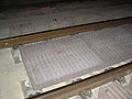
Sound absorbers on slab tracks

System change between the slab track, System Bögl (left) and System Rheda (right)


history
planning
In the early conception phase of the line, in mid-1985, it was planned to return the line from Offenbau on the east side of the freeway near Kleinhöbing to the west side of the freeway and then to lay it in several tunnels. Shortly after crossing the motorway, southwest of Großhöbing , she would have entered a tunnel running to Linden. After a short open section, another tunnel would have followed.
According to other information from 1985, the route south of the Schellenberg tunnel , between Kinding and Ilbing, was supposed to cross the Altmühltal parallel to the autobahn, with a further tunnel up to the Jura level at Gelbelsee .
In a confidential report by the Bavarian State Office for Environmental Protection comparing the Ingolstadt and Augsburg variants, the authority spoke out against the Ingolstadt variant in mid-1990, among other things because of serious interventions in the Heimbach Valley. The Euerwangtunnel was planned with a length of 7.7 km.
In mid-1990, both a continuous tunnel and a chain of tunnels with aboveground interruptions along the motorway were considered in the area of today's tunnel. According to another report, a 7.68 km long tunnel (km 48.97 to 56.65) was planned; the Helmbachtal should be cut at about 52.5 km.
The structure was part of the planning approval section 51 of the new line. In the hearing process , 18 objections were raised against the plans in the section between Günzenhofen and Enkering , which were summarized by the city and handed over to the Federal Railroad. The main point of criticism was the land requirement of the route. In its statement on the planning approval documents, the city of Greding endorsed the arguments put forward by citizens to relocate emergency exits 4 and 5.
According to the planning status of August 1993, a 7700 m long tunnel that was to begin near Günzenhofen was already planned. In mid-1994 the planned length was 7720 m. According to the planning status of 1999, the structure was planned with a length of 7700 m. The end of construction in Lot Mitte , to which the tunnel belonged, was planned for February 28, 2003.
construction
In mid-1996, a 439 m long tunnel leading to the actual driving tunnel was about halfway driven. This intermediate attack, which also served for preliminary exploration, is now used as emergency exit 4/5 and leads out of the tunnel approximately in the middle of the tunnel. It leads to the surface northwest of the Heimbach district of Gredingen at 49 ° 1 ′ 51.7 ″ N , 11 ° 19 ′ 10.5 ″ E.
The driving tunnel was built using mining techniques. A shotcrete construction method was used over a length of 7652 m as well as during the construction of the emergency exits, and a cover construction method on the northern 48 m . The drive was carried out by four attacks at the same time: from the north and south portal and from an intermediate attack (in both directions).
The tunneling from the intermediate attack began in February 1999. From April 1999, preliminary cuts were made in the portal areas. The mining operation began at the beginning of June (south portal) and end of August 1999 (north portal). The breakthrough between the intermediate attack and the south portal took place in June 2000, in a northerly direction on May 2, 2001. That was the last breakthrough of the new line.
A total of 1.1 million cubic meters were excavated for the tunnel and around 7,400 tons of reinforcing steel and 585,000 m³ of concrete were placed.
The tunnel was part of the contract section center of the new line, with which the Hochtief AG ( Munich ) was commissioned.

Construction site in the area of the north portal (2001)

Construction site equipment, still without the north portal (around 2000)

Installation of the slab track in July 2004

Tunnel rescue exercise in May 2006


Installation
The tunnel bang was observed at the Euerwang and Irlahüll tunnels in 2005 during test drives, for the first time in Germany . As a countermeasure, porous, corrugated sound absorber plates were attached between the rails. Nevertheless, a slight tunnel bang can be detected at the south portal of trains traveling at speeds of more than about 250 km / h.
On May 6, 2006, three weeks before the new line went into operation, a rescue exercise with around 250 volunteers took place in the tunnel at km 52.0. A fire on board the train was simulated and an evacuation of the train via two emergency exits and the emergency measures of the responsible rescue workers were rehearsed.
geology
The tube connects the Schwarzach-Thalach valley funnel of the Franconian Alb in the north with the low-lying valleys of the Anlauter and Altmühl in the south. In doing so, he tunnels under the initial albums . The tube lying in the groundwater carries mostly layers of iron sandstone from the Brown Jura .
Due to the surrounding groundwater, the tube had to be watertight over a length of around 6,400 meters.
security concept
The tunnel rises slightly towards the middle ( roof profile ). Thanks to this longitudinal inclination , trains can overcome the rolling resistance even without their own drive and roll out independently with the brakes released. In the tunnel there are, among other things, a dry extinguishing water pipe, BOS radio , emergency telephone and energy extraction points. The safety lighting is normally switched off and not visible.
The structure is equipped with a total of seven emergency exits :
- Emergency exit 1 - the northernmost of the seven - is at km 50.134. There is a lock 16 m behind the tunnel door. From this a 672 m long, drivable tunnel leads in a north-easterly direction into the open. It comes to the west of the Gredingen district of Hausen (at 49 ° 3 '22.3 " N , 11 ° 18' 49.5" E ).
- Emergency exit 2 is at km 51.134. A 290 m long, accessible tunnel leads to the surface on the eastern edge of the Kraftsbuch district (municipality of Greding) (at 49 ° 2 ′ 25.8 ″ N , 11 ° 18 ′ 23 ″ E ).
- Emergency exit 3 leads out of the tunnel at km 51.984. A short connecting passage is followed by a 25 m high shaft with a diameter of 5.8 m, which leads to the surface southeast of Kraftsbuch (at 49 ° 2 ′ 6 ″ N , 11 ° 18 ′ 46.8 ″ E ).
- Emergency exit 4 is at km 52.854 of the driving tunnel. It leads into a 1015 m long drivable gallery that runs parallel to the tunnel to the east. South it leads to approximately 1 km south lying emergency exit 5. The nearby, the north end of the parallel cleat a two-lane, passable tunnel leads to the northeast to 432 m in length between the force point and Heimbach (at 49 ° 1 '51.7 " N , 11 ° 19 ′ 10.5 ″ E ) to the surface.
- Emergency exit 5 is at km 53.854. It leads over the parallel gallery east of the driving tunnel to emergency exit 4 1 km north and over the gallery there (432 m) to the open air.
- Emergency exit 6 is at km 54.854. A drivable tunnel 1015 m long leads east parallel to the driving tunnel to emergency exit 7 and via the tunnel there to the outside.
- The southernmost emergency exit, No. 7, is at 55.854 km. A 1015 m long parallel tunnel connects to the emergency exit 6 in a northerly direction (around 1 km). A drivable, 448 m long tunnel leads from the exit area in a south-easterly direction to the surface, about 200 m west of Autobahn 9 (at 49 ° 0 ′ 29.2 ″ N , 11 ° 21 ′ 5.4 ″ E ). Access via a motorway parking lot is possible.
The total length of the (vertical) shafts and (horizontal) tunnels is around 3940 meters.
See also: Route safety concept

Emergency exit door from the driving tunnel

Spiral staircase leading to the surface with fire-fighting water pipe
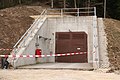
Emergency exit 1 on the surface
Emergency exit 2 on the surface

Emergency exit 3 on the surface

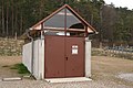
Emergency exit 4/5 on the surface
Emergency exit 6/7 on the surface

View from the south portal with Anlautertal and Schellenberg


costs
The provisional order value for the entire 18.35 km long central lot was given around 1999 at 638 million DM or 327 million euros.
See also
Web links
- Euerwangtunnel. In: Structurae
- Video recordings of the tunnel bang at the Euerwangtunnel
Individual evidence
- ↑ a b c d Hochtief Civil (ed.): Your path is our goal. Nuremberg - Ingolstadt in 30 minutes. 12-page brochure, Munich, approx. 1999, p. 12
- ↑ Is the Federal Railroad now switching to the high-speed line to Munich? . In Schwabacher Tagblatt , July 6, 1985
- ↑ Kinding joins wave of protests . In: Eichstätter Kurier . No. 177 , August 3, 1985, pp. 28 .
- ↑ Wolfgang Krach: "Irreversible damage caused by the ICE" . In: Donaukurier . No. 183 , August 10, 1990, ZDB -ID 1477609-1 , p. 4 .
- ^ "North-South divide" in the rejection . In: Donaukurier . No. 184 , August 11, 1990, ZDB ID 1477609-1 .
- ↑ In the underground it goes south . In: Hilpoltsteiner Kurier . August 28, 1990, ZDB ID 1256658-5 .
- ↑ Günter Strappler, Heinz-Dieter Könnings: New Nuremberg - Ingolstadt line sticking points in the handling of tunnel projects. In rock construction. ISSN 0174-6979 , Vol. 17 (1999), No. 5, pp. 358-366.
- ^ ICE construction worries the population . In: Hilpoltsteiner Kurier . April 1, 1993, ZDB ID 1256658-5 .
- ^ Richard Menius: The new Nuremberg – Ingolstadt line . In: Deutsche Bahn . No. 9/10 , 1993, ISSN 0007-5876 .
- ^ Deutsche Bahn, Network Division, Regional Area Nuremberg (ed.): New Nuremberg – Ingolstadt line . 12-page brochure dated July 1994, p. 5
- ↑ a b Planungsgesellschaft Bahnbau Deutsche Einheit mbH (publisher): Nuremberg – Munich in one hour . Nuremberg, November 30, 1999 (similar version from January 1999 as PDF file , 2.3 MB), pp. 7, 9
- ↑ Astrid Pfeiffer: The way is being prepared for the new ICE route . In: Süddeutsche Zeitung , regional edition Bavaria, July 4, 1996, p. 46
- ↑ G. Brux: Tunnel Bang: Origin and Countermeasures. In Bautechnik , issue 10/2011, p. 731 f. doi: 10.1002 / bate.201101504