
Yourwanger Bühl
| Yourwanger Bühl | ||
|---|---|---|
 Euerwanger Bühl, Lean grass |
||
| height | 595.3 m above sea level NN | |
| location | in the district of Roth near Greding | |
| Mountains | Franconian Alb | |
| Coordinates | 49 ° 1 '5 " N , 11 ° 19' 44" E | |
|
||

The Euerwanger Bühl is an elevation near Euerwang , a district of the Middle Franconian community Greding in the Roth district in Bavaria .
Geographical location
The mountain is located about four kilometers southwest of Greding and 800 meters east of Euerwang.
description
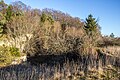
The mountain is located in the southern Franconian Alb and has a height of 595.3 m above sea level. NN . It towers above the surrounding plateau and is one of the highest peaks in the Roth district. It is best known for the Euerwangtunnel , a tunnel on the Nuremberg-Munich ICE line that runs through the mountain. The hilltop area is wooded and consists of the banked Dolomites of the Malm Epsilon , which are covered by low-thickness rubble down the slope. On the south-western slope there is a typical grassland meadow with a sparse tree population that is under landscape protection. There is a Friends of Nature House near the summit . The geotope cave system at Euerwanger Bühl can be found in an abandoned quarry to the south .
Johann Kaspar Bundschuh describes the mountain as follows around 1800: “ Eywangerberg, Eyerwangerberg , is the highest mountain in the whole of the Principality of Eichstätt, sits on top of another mountain , towers above all others, and is seen far and wide, just like him a very great view, namely as far as Nuremberg in bright weather, which is 18 hours away. It takes its name from the Filialdorfe Eyerwang, which leans at the foot of the Eyerwang mountain, with which it rises on the mountain below, and is famous not only for its height, but also for the good herbs it carries and for herbalists can also be collected from remote areas. "
Geotope

The cave system at Euerwanger Bühl is designated by the Bavarian State Office for the Environment as geotope 576H001 and in the cave register Fränkische Alb (HFA) as K 34. A cave ruin was cut here while road gravel was being removed. In the cave, the remains of animals of the Pleistocene and Holocene were found over a height difference of 30 meters with 15 horizons . In the older deposits, remains of large mammals such as mammoth , horse , bison and reindeer were found, which may have been left behind by hunters from the Ice Age . The younger horizons contained small mammals and snail faunas , which can be assigned to the Würmglacial and the Altholocene . In addition to the animal remains, there were also traces of campfires and stone tools from the early Mesolithic (around 9,000 to 10,000 years old). It is also worth mentioning large deposits of cave sinter , which were found in various places in the cave ruins. C14 examinations showed an age of 32,000, 174,000 and 180,000 years for various sintered plates. Today, most of the caves have been filled up again and the quarry has overgrown. Based on the finds, the area is designated as a ground monument D-5-6933-0009.
Say
The vernacular tells that on March 18, 1822 from 9:00 p.m. to midnight, the “Euerwangerbügel” spat fire and threw out ashes, stones and coals. - Probably a small tectonic earthquake ( collapse quake ), as it happens from time to time in the Jura, gave rise to this legend. - Another legend wants to know that 500 years ago there was a farm on the bracket, on which a village nobility with large forest holdings sat; the stone remnants were used to clear away and the last remaining cellar hole was filled with rubbish.
View of the geotope

The upper cave

The lower cave from the inside


See also
literature
- Grießberger: A strange mountain in the Franconian Alb (Euerwanger Bühel). In: The Franconian Alb, Nuremberg, 1 (1916), No. 1, p. 4 f.
Web links
Individual evidence
- ↑ Location in the BayernAtlas (accessed on January 10)
- ^ Johann Kaspar Bundschuh: Geographical Statistical-Topographical Lexicon of Franconia , II. Bd., Ulm 1800, column 112 f.
- ↑ Geotope: cave system at Euerwanger Bühl (accessed on January 10, 2014)
- ↑ Geotopes in Middle Franconia, Bavarian State Office for the Environment, page 108 ff
- ↑ Architectural monuments in Greding (accessed on January 10, 2014)
- ↑ The secret of the Euerwanger temple. In: Heimgarten 20th year, No. 5 from September 29, 1949