
Langenaltheim
| coat of arms | Germany map | |
|---|---|---|

|
Coordinates: 48 ° 54 ' N , 10 ° 56' E |
|
| Basic data | ||
| State : | Bavaria | |
| Administrative region : | Middle Franconia | |
| County : | Weissenburg-Gunzenhausen | |
| Height : | 555 m above sea level NHN | |
| Area : | 39.07 km 2 | |
| Residents: | 2200 (Dec. 31, 2019) | |
| Population density : | 56 inhabitants per km 2 | |
| Postcodes : | 91799, 91788 | |
| Area code : | 09145 | |
| License plate : | WUG, GUN | |
| Community key : | 09 5 77 148 | |
| LOCODE : | DE LNT | |
| Community structure: | 9 parts of the community | |
| Address of the municipal administration: |
Untere Hauptstr. 15 91799 Langenaltheim |
|
| Website : | ||
| Mayor : | Alfred Maderer ( Free Voters ) | |
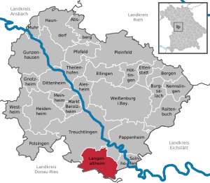
| Location of the community of Langenaltheim in the Weißenburg-Gunzenhausen district | ||
  |
||

Langenaltheim is a municipality in the Weißenburg-Gunzenhausen district in Central Franconia . It is the southernmost municipality in Middle Franconia and therefore the whole of Franconia . Located in the border triangle , the community borders on Upper Bavaria and Swabia .
geography

Geographical location
Langenaltheim is located in the south of the Weißenburg-Gunzenhausen district at about 556 m above sea level. NHN in the highlands of the Weißenburger Alb , a part of the Franconian Alb mountains . The place is about eight kilometers south of the city of Treuchtlingen and about four kilometers west of the Altmühl in the West Central Franconia region and in the middle of the Altmühltal Nature Park . There are several extensive forests in the municipality, including the Oberholz forest south of Langenaltheim . In the southernmost point of the municipality lies the Röglinger Tal , where the triangle marked with a stele, the southernmost point of Franconia and the westernmost point of Upper Bavaria is located. Other valleys in the municipality of Langenaltheim are, for example, the Rehlinger Tal and the Pappenheimer Tal . State road 2217 leads through Langenaltheim, and federal road 2 crosses the municipality to the west of the town center. In the forests of Langenaltheim several works can be found in which Treuchtlinger marble and Solnhofen limestone are mined. The former quarry southeast of the Langenaltheimer Haardt is designated as a geotope and was voted 71st of the most beautiful geotopes in Bavaria . The area of the municipality is mountainous, lying on the municipal area including the Stone Bass ( 571.7 m above sea level. NHN ), the Kühberg ( 556.5 m above sea level. NHN ) and the Schrandelberg ( 568 m above sea level. NHN ).
The neighboring communities are:
| Treuchtlingen | Treuchtlingen | Pappenheim |
| Monheim |
.svg)
|
Solnhofen |
| Monheim | Monheim , Rögling , Mörnsheim | Mörnsheim |
Community structure
The municipality has 9 officially named parts of the municipality (the type of place is given in brackets ):
|
|
There are the districts of Büttelbronn, Langenaltheim and Rehlingen.
history
Until the church is planted
Since 1541 Langenaltheim belonged to the Grafschaft Pappenheim , which was part of the Franconian knight circle . With the Rhine Confederation Act in 1806 the place, like other places in Franconia , became part of the Kingdom of Bavaria . In 1818, the municipality Langenaltheim was created with the municipal edict as part of the administrative reform.
Incorporations
On April 1, 1971, the previously independent municipality of Rehlingen was incorporated. On January 1, 1972, Höfen, Lohhof and Neuherberg were added as parts of the dissolved municipality of Haag near Treuchtlingen . Büttelbronn followed on May 1, 1978.
Population development
- 1961: 2447 inhabitants
- 1970: 2383 inhabitants
- 1987: 2224 inhabitants
- 1991: 2356 inhabitants
- 1995: 2562 inhabitants
- 2000: 2523 inhabitants
- 2005: 2434 inhabitants
- 2010: 2334 inhabitants
- 2015: 2227 inhabitants
coat of arms
The coat of arms description reads: Under the shield head with monkshood of silver and blue in red a silver two-pointed hammer with a golden handle, accompanied by three, two to one, five-pointed silver stars.
Culture and sights

The Willibald Church and the Johanniskirche (both Protestant) are located in Langenaltheim .
Soil monuments
See: List of ground monuments in Langenaltheim
Economy and Infrastructure
Economy including agriculture and forestry
In 1998 there were 197 people at the place of work according to official statistics in the manufacturing sector and no employees subject to social insurance contributions in the trade and transport sector. 123 people were employed in other economic sectors subject to social security contributions. There were a total of 814 employees at the place of residence subject to social security contributions. There were twelve companies in the manufacturing sector and three in the construction sector. In addition, in 1999 there were 45 farms with an agricultural area of 1482 hectares, of which 793 hectares were arable land.
education
In 2013 the following institutions existed:
- Kindergarten: 100 kindergarten places with 89 children
- Primary school: one with nine teachers and 140 students
Other facilities
- Outdoor pool with a large sunbathing area
traffic
The state road St 2217 leads past Langenaltheim , which, when coming from Solnhofen , joins Bundesstraße 2 about two kilometers northwest of the town .
Personalities
- Heinrich Forster (1897–1955), SS-Hauptsturmführer and camp leader in concentration camps
- Herbert Ohly (1901–1972), lawyer and mayor of Erlangen
- Hanns Zischler (* 1947), actor, dramaturge, writer, translator, photographer, historian; grew up in Langenaltheim
literature
- Johann Kaspar Bundschuh : Langenaltheim . In: Geographical Statistical-Topographical Lexicon of Franconia . tape 3 : I-Ne . Verlag der Stettinische Buchhandlung, Ulm 1801, DNB 790364301 , OCLC 833753092 , Sp. 265 ( digitized version ).
- Leonhard Schauer: The Jura town of Langenaltheim with its districts Büttelbronn, Rehlingen and the quarry area Langenaltheimer Haardt . Solnhofen 2002, DNB 969343310 .
- Ludwig Stauffer: Langenaltheim, Büttelbronn and Rehlingen in old pictures . Geiger, Horb am Neckar 1998, DNB 960348581 .
Web links
- Entry on the coat of arms of Langenaltheim in the database of the House of Bavarian History
Individual evidence
- ↑ "Data 2" sheet, Statistical Report A1200C 202041 Population of the municipalities, districts and administrative districts 1st quarter 2020 (population based on the 2011 census) ( help ).
- ↑ Dreiländereck in the Röglinger Tal ( Memento of the original from August 22, 2015 in the Internet Archive ) Info: The archive link was automatically inserted and not yet checked. Please check the original and archive link according to the instructions and then remove this notice. : www.diesteinreichen5.de, accessed on January 21, 2014
- ^ Community Langenaltheim in the local database of the Bavarian State Library Online . Bayerische Staatsbibliothek, accessed on December 25, 2019.
- ^ Wilhelm Volkert (ed.): Handbook of Bavarian offices, communities and courts 1799–1980 . CH Beck, Munich 1983, ISBN 3-406-09669-7 , p. 593 .
- ↑ a b c Federal Statistical Office (ed.): Historical municipality directory for the Federal Republic of Germany. Name, border and key number changes in municipalities, counties and administrative districts from May 27, 1970 to December 31, 1982 . W. Kohlhammer, Stuttgart / Mainz 1983, ISBN 3-17-003263-1 , p. 731 .

Absberg | Alesheim | Mountains | Burgsalach | Dittenheim | Ellingen | Ettenstatt | Gnotzheim | Gunzenhausen | Haundorf | Heidenheim | Höttingen | Langenaltheim | Berolzheim market | Meinheim | Muhr am See | Nennslingen | Pappenheim | Pfofeld | Pleinfeld | Polsingen | Raitenbuch | Solnhofen | Theilenhofen | Treuchtlingen | Weißenburg in Bavaria | Westheim