
Nennslingen
| coat of arms | Germany map | |
|---|---|---|

|
Coordinates: 49 ° 3 ' N , 11 ° 8' E |
|
| Basic data | ||
| State : | Bavaria | |
| Administrative region : | Middle Franconia | |
| County : | Weissenburg-Gunzenhausen | |
| Management Community : | Nennslingen | |
| Height : | 523 m above sea level NHN | |
| Area : | 21.97 km 2 | |
| Residents: | 1396 (Dec. 31, 2019) | |
| Population density : | 64 inhabitants per km 2 | |
| Postal code : | 91790 | |
| Area code : | 09147 | |
| License plate : | WUG, GUN | |
| Community key : | 09 5 77 151 | |
| Market structure: | 8 parts of the community | |
Market administration address : |
Schmiedgasse 1 91790 Nennslingen |
|
| Website : | ||
| Mayor : | Günter Obermeyer ( voter group A) | |
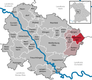
| Location of the Nennslingen market in the Weißenburg-Gunzenhausen district | ||
  |
||

Nennslingen is a market in the central Franconian district of Weißenburg-Gunzenhausen and the seat of the administrative community Nennslingen .
geography
Geographical location
The market is located in the northeast of the district in the West Central Franconia region and about 13 kilometers east of the district town of Weißenburg in Bavaria . It is located on a plateau of the Weißenburger Alb , a partial range of the low mountain range Franconian Alb and is characterized by a wide open landscape. To the northeast of the Biburg district is the easternmost point of the Weißenburg-Gunzenhausen district. In the northeast the border runs to the neighboring district of Roth , in the southeast to the district of Eichstätt in Upper Bavaria . The municipality is between 490 and 576.3 meters ( Kesselberg ) above sea level. The Anlauter flows through the municipality and also the main town in its valley. It is fed by the Hirschgraben and the Erlenbach within the municipality .
The place Nennslingen is at an altitude of 523 m above sea level. NHN and is divided into a western and an eastern half by the Anlauter. The Schwabenweiher is located on the northern edge of the village . The Erlenbach wetland is located north of Nennslingen. The state road St 2227 leads through Nennslingen in the direction of Weißenburg and the district road WUG 14 .
Community structure
The municipality has 8 officially named municipality parts (the type of location is given in brackets ):
|
|
There are the districts Biburg, Gersdorf and Wengen. The Waldmühle and Kappelhof residential areas are not officially designated parts of the municipality.
history
Until the church is planted

It was founded as a place between 400 and 450 years by the Juthungen . The first documentary mention took place in the year 914. Under the Eichstätter Bishop Gundekar II. A church was consecrated in the 11th century. The successor building, a Marienkirche, was still a popular pilgrimage site in the Middle Ages and after the Reformation ; The image of grace was the "Maria hilf" image, which had been housed in a locked box on a side altar since the Reformation and was brought to the parish church of Raitenbuch in 1811 after a public auction in Bavarian times .
The principality of Ansbach and the taverns of Geyern shared control of the place . The rights of the Prussian Principality of Ansbach fell to the Kingdom of Bavaria before the Rhine Confederation Act in 1806 . The rulership rights of the von Geyern taverns in Markt Nennslingen were also mediated in 1806 .
In the 13th century, the von Geyern taverns tried to build up their own domain with Nennslingen as the center. In 1539, Nennslingen was raised to the market . On August 27, 1582, the market was given a coat of arms by Emperor Rudolf II . The award document is still in the possession of the municipality. In 1562 the local lord Konrad von Ehenheim introduced the Reformation at the request of the community . During the Thirty Years' War the place was almost completely depopulated. In 1640 exiles immigrated from Austria . At the beginning of the 19th century, Nennslingen became impoverished as a result of the war burdens from 1805 to 1815. In the course of the administrative reforms in Bavaria, the community of that time was established with the community edict of 1818 .
20th century
Further data: 1954 construction of the water pipe, 1957/58 construction of the Catholic Church of Mariä Namen (since 1960 a branch church of Pfraunfeld ), since the number of Catholics had increased sharply after the Second World War due to displaced persons , from 1960 to 1966 land consolidation . In 1978 the market in Nennslingen became the seat of the administrative community in Nennslingen, which comprises 14 localities with 17 parts of the municipality.
Incorporations
Since May 1, 1978, the previously independent municipalities of Markt Nennslingen, Biburg, Gersdorf and Wengen have been united in the Markt Nennslingen as part of the municipal reform .
Population development
Nennslingen community
- 1961: 1410 inhabitants
- 1970: 1467 inhabitants
- 1987: 1294 inhabitants
- 1991: 1464 inhabitants
- 1995: 1467 inhabitants
- 2000: 1483 inhabitants
- 2005: 1405 inhabitants
- 2010: 1360 inhabitants
- 2015: 1385 inhabitants
Location Nennslingen
- 1861: 653 inhabitants, 172 buildings
- 1950: 913 inhabitants, 138 residential buildings
- 1961: 803 inhabitants, 152 residential buildings
- 1987: 778 inhabitants, 213 buildings with living space
politics
Municipal council
The municipal council in Nennslingen consists of twelve members. After the municipal council election on March 16, 2014, with a turnout of 68.8%, eight seats went to group A (67.6% of the votes) and four to the United voter group (32.4% of the vote).
mayor
Mayor is Günter Obermeyer (voter group A). In 2002 he succeeded Karl Michael Gloßner (voter group A).
coat of arms
|
|
Blazon : “From the open gate of a golden battlement wall gushing silver and blue water that fills the base of the shield; split over the wall; a silver bar in front in black, at the back divided by black and silver. " |
| Crest Reason: In 1582, the market was given by Emperor Rudolf II . the crest. The coats of arms of the two rulers at the time, the Lords of Ehenheim and the Schenk von Geyern , are in the upper half. The wall and the water represent the source of the Anlauter (see picture on the left). King Ludwig I awarded the coat of arms again in 1844. Otto Hupp depicted the wall, the color of which was not specified, in red in his book of coat of arms, while an "earth-colored" wall was specified in the original letter of arms. In 1983, the color of the wall was officially defined as gold, as nowadays heraldry does not usually use brown or earth colors. The representations, some of which are still circulating with a red wall, therefore do not correspond to the official coat of arms. |
Culture and sights
Buildings
Regular events
From 2003 to 2015, the Playground Open Air Festival took place in Nennslingen every year at the beginning of August with well-known bands such as Betontod , Normahl , MC Fitti , Dendemann or Slime .
Soil monuments
See: List of ground monuments in Nennslingen
Economy and Infrastructure
The municipal tax revenue amounted to the equivalent of 571,000 euros in 1999, of which 81,000 euros were trade tax revenue (net).
Economy including agriculture and forestry
In 1998, according to official statistics, there were no employees at the place of work in the manufacturing industry 73 and in the trade and transport sector. In other economic sectors 119 people were employed at the place of work subject to social security contributions. There were a total of 482 employees at the place of residence subject to social security contributions. There was one company in the manufacturing sector and two companies in the main construction sector. In addition, in 1999 there were 77 farms with an agriculturally used area of 1828 ha, of which 1232 ha were arable land and 595 ha were permanent green space.
education
The following institutions exist (as of 2011):
- a kindergarten with 50 places and 54 children
- A primary school with 29 teachers and 301 students. This elementary school, operated by the school association of the municipalities of Nennslingen, Bergen , Burgsalach and Raitenbuch , was converted into a primary and secondary school in the 2011/2012 school year. Due to the declining number of pupils, the middle school was closed at the end of the 2013/14 school year, so that only one elementary school with grades 1 to 4 remained.
Personalities
- Karl Mack von Leiberich (1752–1828), Austrian general and Lieutenant Field Marshal
- Michael Gerstner (1896–1977), German politician ( NSDAP )
- Roland Klick (born July 4, 1939 in Hof), German director. Klick grew up in Nennslingen. In 1964 he shot the short film "Ludwig" with Otto Sander in Nennslingen .
literature
- Johann Kaspar Bundschuh : Nenslingen . In: Geographical Statistical-Topographical Lexicon of Franconia . tape 3 : I-Ne . Verlag der Stettinische Buchhandlung, Ulm 1801, DNB 790364301 , OCLC 833753092 , Sp. 726-727 ( digitized version ).
- Gottfried Stieber: Nenslingen . In: Historical and topographical news from the Principality of Brandenburg-Onolzbach . Johann Jacob Enderes, Schwabach 1761, p. 597-600 ( digitized version ).
- Pleikard Joseph Stumpf : Nensling . In: Bavaria: a geographical-statistical-historical handbook of the kingdom; for the Bavarian people . Second part. Munich 1853, p. 720 ( digitized version ).
Web links
- Website of the community of Nennslingen
- Entry on the coat of arms of Nennslingen in the database of the House of Bavarian History
Individual evidence
- ↑ "Data 2" sheet, Statistical Report A1200C 202041 Population of the municipalities, districts and administrative districts 1st quarter 2020 (population based on the 2011 census) ( help ).
- ^ Municipality of Nennslingen in the local database of the Bavarian State Library Online . Bayerische Staatsbibliothek, accessed on December 25, 2019.
- ↑ Pastoral Journal of the Diocese of Eichstätt , 5 (1858), p. 191.
- ↑ a b Federal Statistical Office (ed.): Historical municipality register for the Federal Republic of Germany. Name, border and key number changes in municipalities, counties and administrative districts from May 27, 1970 to December 31, 1982 . W. Kohlhammer, Stuttgart / Mainz 1983, ISBN 3-17-003263-1 , p. 731 .
- ↑ a b Bavarian State Statistical Office (ed.): Official city directory for Bavaria, territorial status on October 1, 1964 with statistical information from the 1961 census . Issue 260 of the articles on Bavaria's statistics. Munich 1964, DNB 453660959 , Section II, Sp. 835 ( digitized version ).
- ↑ a b Bavarian State Office for Statistics and Data Processing (Ed.): Official local directory for Bavaria, territorial status: May 25, 1987 . Issue 450 of the articles on Bavaria's statistics. Munich November 1991, DNB 94240937X , p. 352 ( digitized version ).
- ^ Joseph Heyberger, Chr. Schmitt, v. Wachter: Topographical-statistical manual of the Kingdom of Bavaria with an alphabetical local dictionary . In: K. Bayer. Statistical Bureau (Ed.): Bavaria. Regional and folklore of the Kingdom of Bavaria . tape 5 . Literary and artistic establishment of the JG Cotta'schen Buchhandlung, Munich 1867, Sp. 1100 , urn : nbn: de: bvb: 12-bsb10374496-4 ( digitized version ).
- ↑ Bavarian State Statistical Office (ed.): Official place directory for Bavaria - edited on the basis of the census of September 13, 1950 . Issue 169 of the articles on Bavaria's statistics. Munich 1952, DNB 453660975 , Section II, Sp. 1140 ( digitized version ).
- ↑ Klemens Stadler: German coat of arms . tape 6 . Bremen 1968 .; Eugen Schöler: Historical family coat of arms in Franconia (= J. Siebmachers Grosses Wappenbuch . F). Neustadt a. d. Aisch 1975 (p. 95, plate 1 (Schenk von Geyern), p. 41, plate 2 (von Ehenheim)).
- ↑ Playground Open Air Nennslingen. Retrieved August 23, 2012 .
- ↑ Table template for the Raitenbuch municipal council meeting on May 8, 2014.
- ^ Clemens Victor Henle: Filmmuseum: Kinofilme vom Meister. Retrieved September 22, 2019 .

Absberg | Alesheim | Mountains | Burgsalach | Dittenheim | Ellingen | Ettenstatt | Gnotzheim | Gunzenhausen | Haundorf | Heidenheim | Höttingen | Langenaltheim | Berolzheim market | Meinheim | Muhr am See | Nennslingen | Pappenheim | Pfofeld | Pleinfeld | Polsingen | Raitenbuch | Solnhofen | Theilenhofen | Treuchtlingen | Weißenburg in Bavaria | Westheim