
Absberg
| coat of arms | Germany map | |
|---|---|---|

|
Coordinates: 49 ° 9 ' N , 10 ° 53' E |
|
| Basic data | ||
| State : | Bavaria | |
| Administrative region : | Middle Franconia | |
| County : | Weissenburg-Gunzenhausen | |
| Management Community : | Gunzenhausen | |
| Height : | 467 m above sea level NHN | |
| Area : | 18.98 km 2 | |
| Residents: | 1382 (December 31, 2019) | |
| Population density : | 73 inhabitants per km 2 | |
| Postal code : | 91720 | |
| Area code : | 09175 | |
| License plate : | WUG, GUN | |
| Community key : | 09 5 77 111 | |
| LOCODE : | DE AB4 | |
| Market structure: | 10 parish parts | |
| Association administration address: | Frankenmuther Str.2d 91710 Gunzenhausen |
|
| Website : | ||
| First Mayor : | Helmut Schmaußer (voters group "New Village Absberg") | |
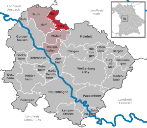
| Location of the Absberg market in the Weißenburg-Gunzenhausen district | ||
  |
||


Absberg is a market in the central Franconian district of Weißenburg-Gunzenhausen and a member of the Gunzenhausen administrative community .
geography
Geographical location


The community is located in the north of the Weißenburg-Gunzenhausen district, in the middle of the Franconian Lake District on a mountain spur above the Kleiner Brombach . The Igelsbachsee and the Große Brombachsee are in the immediate vicinity . The nearest towns are Spalt five kilometers away and Gunzenhausen nine kilometers away . North of Absberg is the border with the neighboring district of Roth . The terrain is hilly and characterized by meadows and fields. There are several springs in the municipality, including those of the Igelsbach . The highest elevation of the community is the Reckenberg , namesake of the Reckenberg group . The community is located in the Spalter hill country .
The peninsula nature reserve in the Kleiner Brombachsee is located on the south bank of the Kleiner Brombachsee . To the north of Absberg lies the protected area of the Igelsbachsee's reservoir root . On the other side of the lake is the Sägmühle nature reserve .
The neighboring communities are Pleinfeld , Haundorf , Spalt and Pfofeld .
.jpg)
Community structure
The municipality has ten officially named parts of the municipality (the type of place is given in brackets ):
|
There are the districts Absberg, Kalbensteinberg and Igelsbach.
history
Until the church is planted
Absberg was first mentioned in a document in 948. In 1455 the place got the right to the ban on blood . After the von Absberg family died out in 1647, whose ancestral seat was the abandoned Absberg Castle , in 1651 the Teutonic Order received the Imperial Fief of Absberg after several years of inheritance disputes. In 1725 Karl Heinrich von Hornstein built the Absberg Castle . The office of the Coming Ellingen of the Teutonic Order, occupied by Prussia in 1796, was exchanged with the Principality of Ansbach in the Treaty of Paris (February 1806) to form the Kingdom of Bavaria. The rights of the Teutonic Order were sequestered by Bavaria in 1806 , although de jure it was not abolished until 1809. In 1818 the political municipality was established.
Incorporations
Until the municipal reform , Absberg belonged to the former district of Gunzenhausen . On May 1, 1978, the previously independent municipality of Kalbensteinberg was incorporated with its Igelsbach district. All places came to the district of Weißenburg-Gunzenhausen.
Population development
| Population development | ||||||||||||||
|---|---|---|---|---|---|---|---|---|---|---|---|---|---|---|
| year | 1900 | 1925 | 1950 | 1961 | 1970 | 1987 | 1991 | 1995 | 2000 | 2005 | 2010 | 2015 | 2016 | |
| Residents | 1185 | 1267 | 1592 | 1335 | 1224 | 1179 | 1215 | 1220 | 1289 | 1298 | 1311 | 1340 | 1353 | |
politics
Municipal council
The municipal council, elected in the 2014 municipal elections, has 12 members. The New Village list has six municipal councils, the Kalbensteinberg electoral group four and the Igelsbach electoral group two municipal councils.
Community finances
In 2012, the municipal tax revenue amounted to 672,000 euros, of which 75,000 euros were trade tax revenues (net).
coat of arms
The description of the coat of arms reads: "In silver over a black three-mountain, a looped red rafter."
Culture and sights
Absberg has two churches worth seeing, the Evangelical Lutheran Christ Church from the late Gothic period , built in 1597/98, and the Catholic parish church of St. Ottilia as a former castle chapel, a rococo sacral room from 1724 to 1726. It is located in the baroque Absberg Castle , the former Bailiwick of the Teutonic Order, in the town center. The Rieterkirche is located in the Kalbensteinberg district .

Evangelical Christ Church Absberg

Interior view of the Catholic parish church of St. Ottilia


Economy and Infrastructure
tourism
The Absberg market has been a state-approved resort since 1998 and, due to its central location (directly on the Kleiner Brombachsee, approx. 2 km from the Großer Brombachsee and Igelsbachsee), it is particularly popular with holidaymakers in summer, especially from the Nuremberg region, for recreation . The vacation there is mainly used for swimming, sailing , surfing , hiking , cycling and camping. Absberg has 57 registered overnight accommodations, including holiday apartments, holiday homes and guest houses.
economy
In 2010 there were 65 employees in the manufacturing sector and 72 in the trade and transport sector. 403 people were employed in other economic sectors. There were a total of 441 employees at the place of residence. There were none in manufacturing, mining and the extraction of stones and earth, and there were five in the main construction trade. In addition, there were 33 farms with an agricultural area totaling 694 hectares. Of this, 417 hectares were arable land and 258 hectares were permanent green space. A facility of the Regens Wagner Foundation in the Müssighof part of the municipality enables people with disabilities to work.
traffic
Several district roads lead through Absberg , which connect the place with the surrounding places as well as with the state road St 2222 and the federal road 466 . For tourist purposes, the MS Brombachsee , a trimaran that is unique in Europe with its architecture and construction, runs between the Ramsberg , Absberg, Enderndorf , Allmannsdorf and Pleinfeld piers during the summer months .
education
- In the community kindergarten with 50 kindergarten places, 31 children are cared for in two groups.
- Absberg is a member of the Absberg-Haundorf School Association. The primary and secondary school is located in Graefensteinberg , a district of the Haundorf community .
Sons and Daughters of the Market
- Matthias Ehrenfried (1871–1948), Bishop of Würzburg
- Karl Butzengeiger (1882–1962), bank manager
- Karl Kahn (1900–1966), politician
- Reinhold Tiling (1893–1933), engineer, pilot and rocket pioneer
literature
- Walter Bauer (ed.): Absberg - a thousand-year history. Wendelsheim 1993
- Johann Kaspar Bundschuh : Absperg . In: Geographical Statistical-Topographical Lexicon of Franconia . tape 1 : A-egg . Verlag der Stettinische Buchhandlung, Ulm 1799, DNB 790364298 , OCLC 833753073 , Sp. 9 ( digitized version ).
- Pleikard Joseph Stumpf : Absberg . In: Bavaria: a geographical-statistical-historical handbook of the kingdom; for the Bavarian people . Second part. Munich 1853, p. 722 ( digitized version ).
Web links
- Homepage
- Entry on the coat of arms of Absberg in the database of the House of Bavarian History
Individual evidence
- ↑ "Data 2" sheet, Statistical Report A1200C 202041 Population of the municipalities, districts and administrative districts 1st quarter 2020 (population based on the 2011 census) ( help ).
- ↑ Markt Absberg: Municipal Council. Retrieved May 9, 2020 .
- ^ Parish Absberg in the local database of the Bayerische Landesbibliothek Online . Bayerische Staatsbibliothek, accessed on December 25, 2019.
- ↑ Markt Absberg: A great story. Retrieved May 9, 2020 .
- ^ Federal Statistical Office (ed.): Historical municipality directory for the Federal Republic of Germany. Name, border and key number changes in municipalities, counties and administrative districts from May 27, 1970 to December 31, 1982 . W. Kohlhammer, Stuttgart / Mainz 1983, ISBN 3-17-003263-1 , p. 730 .
- ↑ 09 577 111 Absberg municipal statistics 2013 Market Absberg
- ↑ Bavarian State Office for Statistics and Data Processing, Markt Absberg , accessed on February 6, 2015

Absberg | Alesheim | Mountains | Burgsalach | Dittenheim | Ellingen | Ettenstatt | Gnotzheim | Gunzenhausen | Haundorf | Heidenheim | Höttingen | Langenaltheim | Berolzheim market | Meinheim | Muhr am See | Nennslingen | Pappenheim | Pfofeld | Pleinfeld | Polsingen | Raitenbuch | Solnhofen | Theilenhofen | Treuchtlingen | Weißenburg in Bavaria | Westheim