gap
| coat of arms | Germany map | |
|---|---|---|

|
Coordinates: 49 ° 10 ' N , 10 ° 56' E |
|
| Basic data | ||
| State : | Bavaria | |
| Administrative region : | Middle Franconia | |
| County : | Roth | |
| Height : | 369 m above sea level NHN | |
| Area : | 55.72 km 2 | |
| Residents: | 5047 (Dec. 31, 2019) | |
| Population density : | 91 inhabitants per km 2 | |
| Postal code : | 91174 | |
| Area code : | 09175 | |
| License plate : | RH, HIP | |
| Community key : | 09 5 76 147 | |
| LOCODE : | DE SPL | |
| City structure: | 29 parts of the community | |
City administration address : |
Herrengasse 10 91174 gap |
|
| Website : | ||
| First Mayor : | Udo Weingart ( CSU ) | |
| Location of the town of Spalt in the Roth district | ||
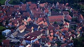
Spalt is a town in the Middle Franconian district of Roth .
geography
Spalt is located in the middle of the Spalter hill country between Nuremberg , Ansbach and Treuchtlingen in the north of the Franconian Lake District . The Große Brombachsee and its pre- dam Igelsbachsee are located in the southwest of the city . The Franconian Rezat flows through the village and joins the Swabian Rezat at Georgensgmünd to form the Rednitz .
Neighboring communities
(clockwise from north.)
City structure
The municipality has 29 officially named parts of the municipality (the type of settlement is indicated in brackets ):
|
|
|
|
history
Early history
The history of the town of Spalt goes back to the St. Salvator Monastery, which was first mentioned in a document in 810. In 2010 the city's anniversary "1200 years of gap" was celebrated. Throughout the year, numerous events were held in the categories LebensLust (regional customs and traditions), LebensWege (Spalter history) and LebensArt (art and culture). In 1031, Spalt and the Spalter wine were mentioned for the first time in a description of the monastery. The place itself was first documented around 1135 as a "column". The place name is derived from the field name of the same name. The rugged cut into the valley of the Franconian Rezat was referred to as gap .
In the years 1294 and 1295, the Eichstatter bishop Reinboto obtained the bailiff rights over Spalt and the surrounding villages from the Regensburg bishop and the Nuremberg burgrave Konrad .
The cultivation of hops in Spalt has been documented since 1341. Around the same time, Spalt was first mentioned as a city. A first city wall with trenches was built in 1366, followed by the Lower Gate (Nürnberger Tor) and the Upper Gate, which is still preserved, by 1422.
In 1450, Spalt was besieged by Nuremberg troops in the course of the First Margrave War , as the Eichstätt diocese stood on the side of the Ansbach margrave Albrecht Achilles . The First Mayor, Hans Gruber, managed to sneak out of the city and get the margrave to help. On the same day he rode into the city with 400 riders, whereupon the surprised people of Nuremberg fled. Since 1950, a local festival with a medieval mercenary camp has been held every five years to celebrate the liberation.
In 1545 and 1632 Spalt and the surrounding area were ravaged by the plague. 450 and 211 people died. During the witch hunt in the Hochstift Eichstätt four women from Spalt were executed as alleged witches. These were Bärbel Kop from Wernfels , † June 25, 1535, Margaretha Hagerin from Spalt, † June 27, 1562, Margaretha Finckhin and Anna Maulin from Güsseldorf , both † July 23, 1575.
During the Thirty Years War , Spalt was occupied by Swedish dragoons in 1632 . Only 13 of 400 Swedes are said to have survived an attack by the Bavarian equestrian general Johann von Werth in the following year. At the end of the war, 48 of the city's 156 town houses were abandoned. In 1647 the choir dome and main wall of the Emmeram Church collapsed.
At the end of the 18th century there were 232 properties in Spalt. The high court was exercised by the Wernfels-Spalt administration office in Eichstatt . The landlords were the Kastenamt Spalt (229 properties: 8 inns, 214 houses, 1 pharmacy, 3 blacksmiths, 2 grinding mills, 1 brick factory) and the collegiate monasteries St. Emmeram and St. Nikolaus (1 house, 1 bath house, 1 blacksmith shop). In addition to the properties, there were stately (rent office buildings), communal (2 schoolhouses, shepherd's house, shepherd's house, hallway apartment, poor house, guard house, shooting house, turret's apartment, 2 gatehouses, 3 towers) and church buildings (rectory, chaplain’s house, pastor’s house, school house, holy church, collegiate church St. Nikolaus, Parish Church St. Emmeram).
In 1802 the Wernfels-Spalt nursing office and thus also Spalt came to the Electorate of Bavaria , briefly to the Kingdom of Prussia in 1803 and to the Kingdom of Bavaria in 1806 through the main state comparison . As part of the municipal edict, the tax district Spalt was formed in 1808 . In 1811 the municipal community Spalt was formed, which corresponded to the tax district. With the second community edict (1818), Spalt was elevated to the rank of second class town. In administration and jurisdiction, it was subordinate to the Pleinfeld Regional Court ( renamed the Roth Regional Court in 1858 ) and the financial management of the Spalt Rent Office ( renamed the Spalt Tax Office in 1920 ). From 1862, Spalt was under the Schwabach District Office (renamed the Schwabach District in 1938 ). The jurisdiction remained until 1879 the District Court Roth, 1880 at the District Court Roth . In 1932 the Spalt tax office was dissolved. Since then, Spalt's financial management has been under the Schwabach tax office . The municipality had an area of 8.313 km².
Incorporations
On January 1, 1972, the previously independent community Großweingarten was incorporated. On July 1, 1972, Enderndorf and Fünfbronn were added, both of which had previously belonged to the Gunzenhausen district. Mosbach and Wernfels followed on May 1, 1978.
Population development
Municipality of Spalt
| year | 1987 | 2007 | 2008 | 2009 | 2010 | 2011 | 2012 | 2013 | 2014 | 2015 | 2016 |
|---|---|---|---|---|---|---|---|---|---|---|---|
| Residents | 4830 | 5069 | 5041 | 5042 | 5002 | 4993 | 4929 | 4918 | 4937 | 4988 | 4947 |
| Houses | 1271 | 1555 | 1565 | 1570 | 1577 | ||||||
| source |
Part of the municipality of Spalt (= municipality of Spalt until the regional reform)
| year | 1818 | 1840 | 1852 | 1855 | 1861 | 1867 | 1871 | 1875 | 1880 | 1885 | 1890 | 1895 | 1900 | 1905 | 1910 | 1919 | 1925 | 1933 | 1939 | 1946 | 1950 | 1952 | 1961 | 1970 | 1987 | 2015 |
|---|---|---|---|---|---|---|---|---|---|---|---|---|---|---|---|---|---|---|---|---|---|---|---|---|---|---|
| Residents | 1474 | 1785 | 1745 | 1778 | 1800 | 1837 | 1805 | 1813 | 1944 | 2060 | 1971 | 1916 | 1858 | 1829 | 1805 | 1782 | 1899 | 1904 | 1955 | 3006 | 2944 | 2916 | 2722 | 2734 | 2531 | 2582 |
| Houses | 321 | 307 | 360 | 356 | 374 | 354 | 406 | 506 | 677 | |||||||||||||||||
| source |
politics
Municipal council
Since the local elections on March 16, 2014, the following parties and constituencies have been represented in Spalt's city council :
| Party / list | Seats | Share of votes |
| CSU | 6th | 32.8% |
| SPD | 2 | 10.7% |
| Independent voter community / Free voters | 3 | 15.0% |
| Women also to the town hall (fair) | 3 | 14.6% |
| Free electorate Großweingarten | 3 | 13.5% |
| Country list | 3 | 13.3% |
The turnout in 2014 was 62.6%.
mayor
Udo Weingart ( CSU ) has been mayor since February 1995 . He was re-elected on November 18, 2012 with 79.7% of the vote.
badges and flags
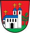
The municipality of Spalt has had its coat of arms in its current form since 1965, which is based on a seal that was first handed down in 1337.
|
Blazon : “In red on a green floor a two-towered silver church with blue roofs, gold crosses on top, an open gate in the nave; on the left accompanied by a green oak . "
Green and white (-green) municipal flag |
|
| Foundation of the coat of arms: The church is supposed to represent the parish and collegiate church of St. Emmeram with the oak standing next to it. |
Town twinning
Since 1984 there has been a town partnership with Bad Sauerbrunn in the Austrian state of Burgenland and since 2006 with St. Cloud in the US state of Minnesota .
Others
Since 2007, Spalt has been part of the municipal alliance KABS , which also includes the political communities Kammerstein, Abenberg, Büchenbach and Rohr.
Culture and sights
Buildings (including museums)
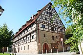
- The Kornhaus is a former tithe barn of the prince-bishops of Eichstätt. The half-timbered building dates from the first half of the 15th century, became the property of the city in 1862 and served as a hop warehouse and hall from 1897 to 1984. The structure is 36 meters long, 13 meters wide and 20 meters high. The building was renovated and redesigned and now the hop and beer museum “HopfenBierGut” and the tourist information office are located there. The “HopfenBierGut” museum was awarded the “ Golden Beer Idea” in 2015 .
- The baroque town hall was built between 1751 and 1756 according to plans by Gabriel de Gabrieli , the court architect in Eichstätt. It initially served as the dean's court. From 1818 to 1932 the Spalt Rent and Tax Office was housed in the building. It has served its current purpose since 1933. Until the completion of the renovation work on the Kornhaus, the town hall also housed the tourist information office.
- The former double canonical house originally served as a refectory for the Canons of St. Nikolaus and St. Emmeram. It was built for this purpose between 1753 and 1756. After secularization , the building was used as a school. Until 1981 it served as a convent for the poor school sisters. The municipal kindergarten is now located there.
- The former collegiate church of St. Nikolaus was built between 1767 and 1771 under the master builder Matthias Binder from Ellingen . This baroque building, which has still been preserved, was the successor to a first church for the Canons' Monastery of St. Nicholas, founded in 1294, which was built on the same site from 1302 to 1313. Donors were the Nuremberg burgrave Konrad II the Pious and his wife Agnes von Hohenlohe. The church passed from the property of the Kingdom of Bavaria to that of the city of Spalt. Inside you can see frescoes by Franz Kurzinger and stucco work by the Wessobrunn school . On the former cemetery wall, 24 old grave monuments can be seen, one of which bears the number 14, the epitaph of the monastery dean Wolfgang Agricola . In the 1960s the church was renovated.

- The parish church of St. Emmeram goes back to the Carolingian monastery of St. Salvator, which was founded in Regensburg. The canons of St. Emmeram emerged from this monastery in Spalt in the 12th century, the church of which was initially designed as a Romanesque basilica, but underwent several renovations in the 16th and 17th centuries, so that it is today, apart from the crypt and the apse , which offers the image of a baroque church. Until 1880 the church still had a rood screen . In the church there is the Spalatin Madonna , which Georg Spalatin gave to the church in 1519. A renovation took place in the 1970s and 1980s.
- The Protestant Christophorus Church is a neo-Gothic sandstone building. It was actually only supposed to be built as a chapel with a turret, but in 1895 it was given a tower that was placed south in front of the nave.
- The cemetery church is consecrated to Saints Johannes Baptist, Stephan and Sebastian. It was redesigned in the baroque style between 1715 and 1717. A votive procession is preached from the outer pulpit on St. John's Day. This custom goes back to the siege of Spalt in 1450. The Ansbach Margrave Albrecht Achilles ended the siege at the point where the new cemetery was laid out in 1556. In addition to the procession and sermon, the festival Die Nürnberger Reis takes place every five years .
- The Catholic rectory was built in 1738 by Moritz Pedetti . The baroque building has beautiful stucco ceilings on the first floor. It served as a vicarage since 1812.
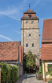
- The Upper Gate Tower dates from 1422. It was built under Prince-Bishop Johann II von Heideck . It was used as living space from 1763. In 1821 it became the property of the town of Spalt. The tower, which now houses the craftsmen's rooms, was renovated in 1974.
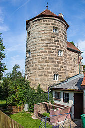
- The tire tower dates from 1446 and was built under Bishop Johann von Aich .
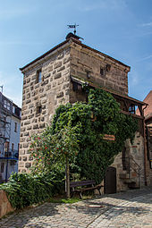
- The shepherd's tower probably dates from the first half of the 14th century and was completed in the middle of the 15th century. It was part of the city fortifications.
- Other towers in Spalt are the Drechslerturm, in which turners worked for a long time, and the Diebsturm, which dates from the 14th century and was part of the city fortifications. It was used as a prison until the 20th century, before the last inmates came to the Roth JVA. The tower is now used by the Heimatverein.
- At the town mill you can still see heraldic stones and individual parts of the former 'Lower Gate' (Nürnberger Tor).
- The Schlenzger House is a half-timbered house integrated into the city wall, which once had a Gothic pointed arched gate . Presumably the Knights of Oppurch used this gate as an entrance to the city.
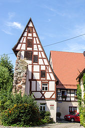
- The customs house from the 18th century with a half-timbered gable is also attached to the city wall . A part of the city wall including the battlements has been preserved at the customs house.
- The small half-timbered house is also a residential building built onto the city wall. It was built around 1800.
- The Dr. Hercules Tower was named after its resident, the physicist Timotheus Herkules. Hercules was a member of the Academy in Paris . He died in Spalt in 1802. The Dr. Hercules Tower was built around 1350 and received its pointed helmet with a gable roof in 1862.
- The Spalatin House is the house where Georg Spalatin was born.
- In the old town hall from 1524 there was an apartment for the clerk since 1753. In 1816 the building became the property of the city. It was used as a town hall until 1933, then as a fire station. It now houses the fire brigade museum .
- Many houses in Spalt are reminiscent of the tradition of growing hops. They have five or six attic storeys where the harvest could be dried and stored. The Mühlreisig Hopfengut from 1746, which is located on the state road towards Wassermungenau, is particularly worth seeing .
- The Kulturbahnhof is a former station of the Spalter Bockl.
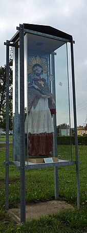
- A figure of St. Nepomuk stands in a glass case on the pedestrian and cyclist footbridge across the Franconian Rezat.
- The Harsdörfer Schlösschen in Enderndorf is used today as the guest house.
- Wernfels Castle now serves as a youth hostel.
nature
Close to Spalt at Schnittling are the deeply cut valleys of the Schnittlinger Loch and at Massendorf the Massendorfer Gorge .
Archaeological sites
- In the vicinity of the Stiegelmühle part of the municipality, traces of the Bärenburg ring wall system can be seen, which is probably a Celtic refuge from the 1st millennium BC. Hiking trails lead around the facility.
- The Thylenburg , a former Carolingian - Ottonian castle from the 9th century, is located near Theilenberg .
Architectural monuments
Planet path
In the summer of 2000, a planet path on a scale of 1: 1 billion was opened between Georgensgmünd and Spalt . Here the sun and the eight planets orbiting it (as well as Pluto) can be found in their distances to one another, shown to scale as a model. Behind the Georgensgmünder Rathausplatz the planet path begins with a sun globe. The route leads along a seven-kilometer cycle path through the Rezat Valley to Spalt, where Pluto as a dwarf planet far from the sun ends the route at the train station. A board for each planet (and Pluto) explains the most important dates.
Sports
- TSV 1890 Spalt (ice stock, football, table tennis)
- Sports bowling club Gut Holz Spalt
- Brombach Lakers e. V.
- SG 1562 gap e. V. (Shooting Society)
- Wanderfreunde Spalt e. V.
- Rad Sport Hügelland e. V.
Regular events
The city has a carnival tradition . In the run-up to the carnival week , three carnival balls called Saumarktball will take place in the Spalter town hall. The highlight of the carnival season is heralded with the nonsensical Thursday , which takes place in the old town with its pubs and taverns. This is followed by the carnival procession in the Großweingarten district on Shrove Saturday, the Rose Monday ball and finally the carnival procession through Spalt on Shrove Tuesday. During these events, the Flecklasmen are up to mischief in their traditional costumes in Spalt. (The children's shouting: "Fleckla, Fleckla have a dirty ass on your ass! Bastard, Lumperdurl, you lost your old Ruuk". (Dialect))
Every July, the Spalter Summer Night Games take place on three weekends in the open-air theater in the Bürgergarten.
Every year at the end of August, the traditional hops-plucking festival, the "Spalter Saumarkt", is celebrated, at which a hop queen is also chosen.
The Funsport Challenge Madmud , known throughout Europe, is held every two years . There are 12 disciplines to be mastered here, such as high ropes courses, diving and bungee running.
The Spalter Christmas Market, which the city advertises as the "Christmas market with that certain something more", is also well-known nationwide. In contrast to most Christmas markets, it is not limited to just one place, but is distributed throughout the old town. In addition to stalls, houses, backyards, historic cellars and parts of the city brewery are also included.
Economy and Infrastructure
Hops and beer
Spalt is the center of the fourth largest hop growing area in Germany after Hallertau , Elbe-Saale and Tettnang . Hops have been grown since 1341. In 1476 there were already 43 hop gardens and only 23 vineyards. In 1538, Spalt received the world's first hop seal . Großweingarten was awarded its own seal in 1753.
Hops have long been the source of Spalter's prosperity and still play an important cultural role in the city today. However, due to more efficient brewing methods and the success of newly developed hop varieties with a higher concentration of the bitter substances required for brewing beer , which are not grown in Spalt, the demand for Spalt hops and the number of hop farmers has decreased.
In 1879 the lamb brewery, founded in 1540, was auctioned by the magistrate of the city of Spalt and became the city's brewery . The Spalt Stadtbrauerei brews Spalter beer from the Spalter aroma hops "Spalt Spalter".
Todays situation
Despite the great historical and cultural importance for the place, hops have largely lost their role as the backbone of the Spalter economy since the middle of the 20th century.
An important economic factor today is tourism, which benefits from the location in the Franconian Lake District and the historic old town. Small and medium-sized industrial companies also play a major role, e.g. B. from metal processing. In the 1990s, the Hügelmühle industrial park was created, in which a number of companies settled.
traffic
Spalt lies almost exactly in the middle between the federal highway 466 and the federal highway 2 and is connected to both by the St 2223 . The district road RH 13 runs south to Enderndorf am See . The district road RH 6 runs west to Schnittling and northeast to Güsseldorf . The district road RH 39 runs north to Massendorf . A community road runs southeast to Großweingarten to the district road RH 16 .
There are bus routes to the surrounding area, including to Georgensgmünd train station on the Treuchtlingen – Nuremberg line and to the district town of Roth. Until September 1969, Spalt was the end of the branch line called Spalter Bockl .
sons and daughters of the town
- Georg Spalatin (1484–1545), Martin Luther's most understanding advocate. He named himself after his hometown.
- Joseph Konrad von Bangold (1780–1851), General from Württemberg
- Joseph Conrad Pfahler (1826–1887), member of the Reichstag and Landtag, university professor
- Hanns Braun (1886–1918), track and field athlete who was successful at the Summer Olympics in London in 1908 and in Stockholm in 1912
- Wolfgang Spann (1921–2013), forensic doctor
- Klaus Bollinger (* 1952), civil engineer
- Hubert Schwarz (* 1954), extreme athlete
- Carlo Rola (1958–2016), screenwriter, director and film producer
- Franz Baader (* 1959), computer scientist, professor at the Technical University of Dresden
- Christian Rohrbach (* 1984), conductor, singer and university lecturer
literature
- Johann Kaspar Bundschuh : Split . In: Geographical Statistical-Topographical Lexicon of Franconia . tape 5 : S-U . Verlag der Stettinische Buchhandlung, Ulm 1802, DNB 790364328 , OCLC 833753112 , Sp. 358-377 ( digitized version ).
- Friedrich Eigler : Schwabach (= Historical Atlas of Bavaria, part of Franconia . I, 28). Michael Laßleben, Kallmünz 1990, ISBN 3-7696-9941-6 , p. 423, 485 .
- Karl Gröber, Felix Mader : City and district of Schwabach (= The art monuments of Bavaria . Middle Franconia 7). R. Oldenburg, Munich 1939, DNB 366496239 , p. 299-376 .
- Wolf-Armin von Reitzenstein : Lexicon of Franconian place names. Origin and meaning . Upper Franconia, Middle Franconia, Lower Franconia. CH Beck, Munich 2009, ISBN 978-3-406-59131-0 , p. 210-211 .
- Pleikard Joseph Stumpf : Split . In: Bavaria: a geographical-statistical-historical handbook of the kingdom; for the Bavarian people . Second part. Munich 1853, p. 752 ( digitized version ).
- Willi Ulsamer (Ed.): 100 Years of the Schwabach District (1862–1962). A home book . Schwabach 1964, DNB 984880232 , p. 560-597 .
Web links
- Website of the city of Spalt
- Column in the Topographia Franconiae of the University of Würzburg , accessed on September 22, 2019.
- Column : Official statistics of the LfStat (PDF; 1.2 MB)
Individual evidence
- ↑ "Data 2" sheet, Statistical Report A1200C 202041 Population of the municipalities, districts and administrative districts 1st quarter 2020 (population based on the 2011 census) ( help ).
- ^ Community Spalt in the local database of the Bavarian State Library Online . Bayerische Staatsbibliothek, accessed on September 22, 2019.
- ↑ Archived copy ( Memento of the original dated February 12, 2013 in the Internet Archive ) Info: The archive link was inserted automatically and has not yet been checked. Please check the original and archive link according to the instructions and then remove this notice.
- ↑ W.-A. v. Reitzenstein, p. 210 f.
- ↑ Stürzl, On the persecution of witches in the upper pen of the Hochstift Eichstätt. Addendum to: Executions for witchcraft in Eichstätt. In: Leaflets of the Bavarian State Association for Family Studies. Self-published, Munich. 2016 p. 128.
- ↑ F. Eigler, p. 423.
- ↑ F. Eigler, p. 485.
- ↑ F. Eigler, p. 464.
- ↑ a b Bavarian State Statistical Office (ed.): Official city directory for Bavaria, territorial status on October 1, 1964 with statistical information from the 1961 census . Issue 260 of the articles on Bavaria's statistics. Munich 1964, DNB 453660959 , Section II, Sp. 826 ( digitized version ).
- ^ Wilhelm Volkert (ed.): Handbook of Bavarian offices, communities and courts 1799–1980 . CH Beck, Munich 1983, ISBN 3-406-09669-7 , p. 568 .
- ^ Federal Statistical Office (ed.): Historical municipality directory for the Federal Republic of Germany. Name, border and key number changes in municipalities, counties and administrative districts from May 27, 1970 to December 31, 1982 . W. Kohlhammer, Stuttgart / Mainz 1983, ISBN 3-17-003263-1 , p. 733 .
- ↑ a b Only inhabited houses are given. In 1818 these were designated as fireplaces , in 1840 as houses , and from 1871 to 2016 as residential buildings.
- ↑ a b Bavarian State Office for Statistics and Data Processing (Ed.): Official local directory for Bavaria, territorial status: May 25, 1987 . Issue 450 of the articles on Bavaria's statistics. Munich November 1991, DNB 94240937X , p. 349 ( digitized version ).
- ↑ a b c d e f g h i j column : Official statistics of the LfStat
- ↑ Alphabetical index of all the localities contained in the Rezatkkreis according to its constitution by the newest organization: with indication of a. the tax districts, b. Judicial Districts, c. Rent offices in which they are located, then several other statistical notes . Ansbach 1818, p. 87 ( digitized version ).
- ↑ Eduard Vetter (Ed.): Statistical handbook and address book of Middle Franconia in the Kingdom of Bavaria . Self-published, Ansbach 1846, p. 219 ( digitized version ). Spalt: 1778 inhabitants, 306 houses; Fallhaus: 7 E., 1 H. According to the historical municipality register , the municipality had 1752 inhabitants.
- ↑ a b c d e f g h i j k l m n Bavarian State Statistical Office (Hrsg.): Historical municipality register: The population of the municipalities of Bavaria from 1840 to 1952 (= contributions to Statistics Bavaria . Issue 192). Munich 1954, DNB 451478568 , p. 184 , urn : nbn: de: bvb: 12-bsb00066439-3 ( digitized ).
- ^ Joseph Heyberger, Chr. Schmitt, v. Wachter: Topographical-statistical manual of the Kingdom of Bavaria with an alphabetical local dictionary . In: K. Bayer. Statistical Bureau (Ed.): Bavaria. Regional and folklore of the Kingdom of Bavaria . tape 5 . Literary and artistic establishment of the JG Cotta'schen Buchhandlung, Munich 1867, Sp. 1090 , urn : nbn: de: bvb: 12-bsb10374496-4 ( digitized ). Spalt: 1784 inhabitants; Fallhaus: 6 E .; Mühlreiße: 10 E.
- ↑ Kgl. Statistical Bureau (ed.): Complete list of localities of the Kingdom of Bavaria. According to districts, administrative districts, court districts and municipalities, including parish, school and post office affiliation ... with an alphabetical general register containing the population according to the results of the census of December 1, 1875 . Adolf Ackermann, Munich 1877, 2nd section (population figures from 1871, cattle figures from 1873), Sp. 1258 , urn : nbn: de: bvb: 12-bsb00052489-4 ( digitized version ).
- ↑ K. Bayer. Statistical Bureau (Ed.): Localities directory of the Kingdom of Bavaria. According to government districts, administrative districts, ... then with an alphabetical register of locations, including the property and the responsible administrative district for each location. LIV. Issue of the contributions to the statistics of the Kingdom of Bavaria. Munich 1888, Section III, Sp. 1192 ( digitized version ). Originally: 256 residential buildings.
- ↑ K. Bayer. Statistical Bureau (Ed.): Directory of localities of the Kingdom of Bavaria, with alphabetical register of places . LXV. Issue of the contributions to the statistics of the Kingdom of Bavaria. Munich 1904, Section II, Sp. 1265 ( digitized version ).
- ↑ Bavarian State Statistical Office (ed.): Localities directory for the Free State of Bavaria according to the census of June 16, 1925 and the territorial status of January 1, 1928 . Issue 109 of the articles on Bavaria's statistics. Munich 1928, Section II, Sp. 1302 ( digitized version ).
- ↑ Bavarian State Statistical Office (ed.): Official place directory for Bavaria - edited on the basis of the census of September 13, 1950 . Issue 169 of the articles on Bavaria's statistics. Munich 1952, DNB 453660975 , Section II, Sp. 1128 ( digitized version ).
- ^ Bavarian State Statistical Office (ed.): Official place directory for Bavaria . Issue 335 of the articles on Bavaria's statistics. Munich 1973, DNB 740801384 , p. 180 ( digitized version ).
- ↑ Population figures on the grossweingarten.de website
- ^ Entry on the coat of arms of Spalt in the database of the House of Bavarian History
- ↑ gap. In: Kommunalflaggen.eu. Retrieved June 9, 2020 .
- ↑ partnership Spalt / St. Cloud on Consulate General Chicago website.Retrieved August 1, 2020
- ^ Municipal alliance KABS
- ↑ Golden Beer Idea - Laureate 1999-2017 Bavarian Brewers Association .


