
Forest Kleinschwarzenlohe

The forest Kleinschwarzenlohe is a municipality-free area in the Central Franconian district of Roth .
The 13.91 km² state forest is the part of the Lorenz Reich Forest north of Wendelstein , west of Feucht , south of Langwasser and east of Worzeldorf . The A 6 and A 73 motorways run through the area and form the Nürnberg-Süd motorway junction in the middle . The Predigtstühlein ( 49 ° 22 ′ 38.68 ″ N , 11 ° 8 ′ 42.32 ″ E ) is 373 m above sea level. NN the highest point in the area. A large part is part of the EU bird sanctuary area Nürnberger Reichswald and the landscape protection area protection of the landscape in the area of the district of Roth - Southern Central Franconian Basin east of the Swabian Rezat and the Rednitz with the foreland of the Middle Franconian Alb (LSG Ost) .
Waters
The Ludwig-Danube-Main Canal crosses the Kleinschwarzenlohe forest. The area is traversed in the east by the Schnackenbach and Ottergraben . West of Feucht is the popular Jägersee bathing lake ( 49 ° 22 ′ 20 ″ N , 11 ° 11 ′ 28 ″ E ). The historic Gauchsbach-Leitgraben runs north of Röthenbach near Sankt Wolfgang .
Worth seeing
The forest is criss-crossed by a few cycling and hiking trails. The Franconian Dune Trail also crosses the area.
Architectural monuments
- Section of the Ludwig-Donau-Main Canal (D-5-76-453-1) ( 49 ° 21 ′ 33.66 ″ N , 11 ° 7 ′ 55.74 ″ E )
- Lock 64 of the Ludwig-Donau-Main-channel (D-5-76-453-2) ( 49 ° 21 '57.85 " N , 11 ° 6' 44.89" O )
- Lock 65 of the Ludwig-Donau-Main-Canal (D-5-76-453-3) ( 49 ° 22 ′ 9.12 ″ N , 11 ° 6 ′ 31.21 ″ E )
- Lock 66 of the Ludwig-Donau-Main-Canal (D-5-76-453-4) ( 49 ° 22 ′ 16.78 ″ N , 11 ° 6 ′ 13.81 ″ E )
- The tailor's cross at Sorger Bridge (D-5-76-151-163) ( 49 ° 21 ′ 24.55 ″ N , 11 ° 7 ′ 21.61 ″ E )
Others
- The Meixnerstein , a memorial stone near Röthenbach near Sankt Wolfgang ( 49 ° 22 ′ 12.25 ″ N , 11 ° 11 ′ 6.36 ″ E ). According to the inscription, it is dedicated to JCMeixner from Nuremberg in 1873 because of a hunting accident.
The route of the former Feucht – Wendelstein railway ran through the forest .
Picture gallery

The small Jägersee west of Feucht

Section of the Ludwig-Danube-Main Canal near Worzeldorf
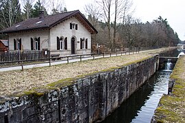
Lock 64 of the Ludwig-Danube-Main Canal

Lock 65 of the Ludwig-Danube-Main Canal

Lock 66 of the Ludwig-Danube-Main Canal

The Meixnerstein near Röthenbach near Sankt Wolfgang
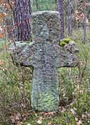
The tailor's cross at the Sorger Bridge


See also
- List of unincorporated areas in Bavaria
- List of architectural monuments in non-parish areas in Bavaria # Forst Kleinschwarzenlohe
- List of locks in the Ludwig-Danube-Main Canal
- List of landscape protection areas in the district of Roth
Coordinates: 49 ° 22 ′ 39 ″ N , 11 ° 8 ′ 11 ″ E
Web links
- Forst Kleinschwarzenlohe in OpenStreetMap (accessed on August 5, 2017)
Individual evidence
- ↑ Area information at www.destatis.de, as of December 31, 2018 , accessed on August 1, 2020.
- ↑ www.protectedplanet.net, Nürnberger Reichswald (accessed on August 4, 2017)
- ↑ 6533-471 Nuremberg Reichswald. (EU bird sanctuary) Profiles of the Natura 2000 areas. Published by the Federal Agency for Nature Conservation . Retrieved November 27, 2017.
- ↑ Bavarian State Forests, Monuments in the Nuremberg Reichswald (accessed on August 14, 2017)

Abenberg | Allersberg | Büchenbach | Georgensgmünd | Greding | Heideck | Hilpoltstein | Kammerstein | Rednitzhembach | Pipe | Roth | Röttenbach | Schwanstetten | Gap | Thalmässing | Wendelstein
Unregulated areas
Abenberger Wald |
Dechenwald |
Forest Kleinschwarzenlohe |
Heidenberg |
Soos