
Gauchsbach-Leitgraben

The Gauchsbach-Leitgraben is an artificial hydraulic structure in the market town of Wendelstein in the Middle Franconian district of Roth in Bavaria .
location

The Leitgraben is located northeast of the Wendelsteiner district Röthenbach near Sankt Wolfgang , on the border to the community-free area of Forst Kleinschwarzenlohe . The Fränkischer Dünenweg hiking trail ( ![]() ) leads largely along the Graben.
) leads largely along the Graben.
description
Guiding ditches served the water supply of the Ludwig-Danube-Main Canal , especially in the area of the apex or longer lock positions . They were necessary to compensate for the loss of water through sluice, evaporation and infiltration. This was the only way to guarantee the minimum water depth of 1.17 meters required for canal shipping. The specially built and paved trenches lead the water from distant waters into the canal. For this purpose, devices with adjustable drains for the guide ditches and streams were built on the streams concerned. In order to serve as a tributary, the level of the trenches had to be higher than the respective section. It was a masterpiece of planning to lead the route - especially in the area of the apex support - in such a way that the filling of the available watercourses was sufficient to supply the canal even during times of scarce water.
One of these guide ditches is the Gauchsbach guide ditch. It was created between 1836 and 1845 as part of the construction work on the Ludwig-Danube-Main Canal. It is named after the supplying Gauchsbach . About 800 meters of piping are made from the 1500 meter long course. Here it was used to supply the 4,700 meter long section between lock 63 in Röthenbach near Sankt Wolfgang and lock 64 east of Kornburg . The Leitgraben is still fully functional today and also supplies the Ludwig Canal from time to time. With a maximum discharge of around 60 l / s, it delivers the second largest water supply in the canal after the Pilsach-Leitgraben in Neumarkt in the Upper Palatinate .
The entire Leitgraben has been designated as a building and soil monument by the Bavarian State Office for the Preservation of Monuments (D-5-76-151-136, D-5-6633-0196).
course
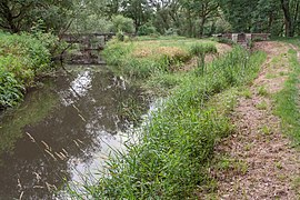
To the south of the Feuchter Krugsweiher , the Gauchsbach is diverted. There are two separate gates and a weir to regulate the water distribution . The two structures and walkways of the facility were completely renovated in 2009. The guide ditch is largely enclosed in its open course with rubble stones. It initially leads in a straight line in a southerly direction to the A73 . In its course it is crossed by a modern small bridge. South of the autobahn, it runs parallel to the Gauchsbach and is crossed again by a historic stone arch bridge shortly before Röthenbach. To the south of the bridge, the spoil heaps of the excavated earth are still clearly visible on the left side of the trench. Behind the new Röthenbacher cemetery, the so-called Thürnersfeld construction area, it was completely piped in the 1970s until the final inlet into the Ludwig Canal . The final entry into the Ludwig Canal takes place under the road bridge at the former lower head of lock 63.
Problems
The book The Ludwig Canal - Its Origin and Significance as a Trade Route reports on problems in the construction of the Ludwig Canal in the area of the introduction of the Gauchsbachleitgraben:
In order to compact the stretch from the Schwarzachbrück Canal to lock 56 (today lock no. 63) near Röthenbach, where the Gauchsbach-Leitgraben flows into it, water that ran over the Schwarzachbrück Canal in a wooden channel was used. Most of the difficulty arose in the vicinity of the lock just mentioned. The canal has a very rugged, leafy Keuper rock as a base. The water seeped through this in such an amount that the residents of the village of Röthenbach were bothered by it because it penetrated into the cellars, stables and living rooms below. On August 29, 1844, a dam breach occurred at the northern end of the Gauchsbach-Brück Canal, in which a piece of the left-hand dam, which is located on the sloping and jagged Keuper rock, slid down into the deeply cut Gauchsbach, which ran parallel to the canal itself at this point . Since shipping on this route was not yet underway at the time, the incident was of no further concern, all the less because the damage could be repaired in a short time.
Picture gallery
Gauchsbach exit into the guide ditch

Gauchsbach weir and footbridge

Guideway gate and footbridge

Route north of the A73

Course south of the A 73 with spoil dump

Arch bridge at Röthenbach
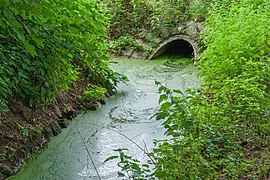
Outlet of the A 73, piping

Start of piping in Röthenbach

Canal discharge under the bridge


Individual evidence
- ↑ OpenStreetMap, course of the Gauchsbach-Leitgraben (accessed on July 7, 2018)
- ↑ Information board on the canal (accessed on July 7, 2018)
- ↑ Working group Chronik Feucht, Der Gauchsbach, plate 14: 14. The Gauchsbachleitgraben
- ↑ Bavarian State Office for the Preservation of Monuments, Wendelstein List (accessed on July 7, 2018)
- ↑ Copy Schultheis, Friedrich: The Ludwig Canal - Its Origin and Significance as a Trade Route - with 26 views engraved in steel by Alexander Marx, Nuremberg, 1847 (accessed on July 7, 2018)
Web links
Coordinates: 49 ° 22 '4.3 " N , 11 ° 11' 5.28" E