
Allersberg
| coat of arms | Germany map | |
|---|---|---|

|
Coordinates: 49 ° 15 ' N , 11 ° 14' E |
|
| Basic data | ||
| State : | Bavaria | |
| Administrative region : | Middle Franconia | |
| County : | Roth | |
| Height : | 385 m above sea level NHN | |
| Area : | 59.72 km 2 | |
| Residents: | 8374 (Dec. 31, 2019) | |
| Population density : | 140 inhabitants per km 2 | |
| Postal code : | 90584 | |
| Area code : | 09176 | |
| License plate : | RH, HIP | |
| Community key : | 09 5 76 113 | |
| Market structure: | 26 parts of the community | |
Market administration address : |
Marktplatz 1 90584 Allersberg |
|
| Website : | ||
| Mayor : | Daniel Horndasch (Free Voters / Allersberg Citizens' Forum) | |
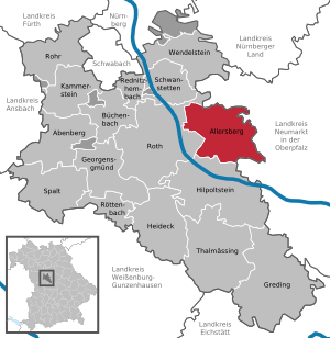
| Location of the Allersberg market in the Roth district | ||
  |
||


Allersberg is a market in the Central Franconian district of Roth .
geography
location
The community is located 25 kilometers southeast of Nuremberg on the northwestern edge of the Franconian Alb at an altitude of 353 m above sea level. NN . The Kleine Roth flows through Allersberg and flows into the Rothsee , which is part of the Franconian Lake District , about two and a half kilometers southwest of the town .
Community structure
The municipality has 26 officially named parts of the municipality (the type of settlement is indicated in brackets ):
|
|
|
|

Unlike the other places, Realsmühle has the postcode 92342.
The following districts exist : Allersberg, Altenfelden, Brunnau, Ebenried, Göggelsbuch, Lampersdorf, Wagnersmühle, Guggenmühle, Uttenhofen, Eismannsdorf, Eisbühl, Reckenricht, Reckenstetten, Polsdorf, Fischhof, Eppersdorf, Schönbrunn, Appelhof, Harrhof.
history
Until the 19th century
Allersberg was first mentioned in 1254 as the center of a parish. In 1323 it was granted market rights by Ludwig the Bavarian , which in 1354 was extended by Emperor Charles IV . The Wolfstein family lived in Allersberg until 1475 and founded the first hospital there in 1339 . Afterwards the Hochstift Eichstätt enfeoffed Duke Ludwig the Rich with Allersberg, which resulted in Bavaria-Landshut .
Before 1800 Allersberg was a nursing office and belonged to the Wittelsbach duchy of Neuburg-Sulzbach, which came to Bavaria in 1777 . Allersberg had market rights with its own magistrate rights. From 1689 to 2006 the place was the seat of the Jacob Gilardi company , the oldest manufacturer of Leonean goods in Germany.
20th century
Towards the end of the Second World War , Allersberg was badly damaged in April 1945 during fighting against the advancing 7th US Army .
Incorporations
On July 1, 1971, the previously independent communities of Altenfelden and Göggelsbuch were incorporated. On January 1, 1972, Ebenried and parts of the communities of Brunnau and Lampersdorf followed. Parts of the Birkach area were added on May 1, 1973.

Population development
|
At the beginning of 2009 the population was distributed as follows:
|
politics


Market council
The market council consists of 20 members. With a turnout of 59.7%, the 2020 local elections led to the following result:
| Political party | CSU | FW | ABF * | SPD | Green |
| Seats | 6th | 6th | 4th | 2 | 2 |
| Share of votes | 28.91% | 27.30% | 21.30% | 11.80% | 10.69% |
* Allersberg Citizens' Forum
mayor
- First Mayor: Daniel Horndasch (independent) (since August 2017);
- Second Mayor: Rainer Just (FW);
- Third Mayor: Bernd Schneider (ABF)
Town twinning
-
 Saint-Céré in the French region of Occitania has been Allersberg's partner municipality since 1985.
Culture and sights
Education and Social
- four church-run kindergartens
- Sybilla Mason Elementary School
- Allersberg Middle School
- Technical school for curative education care
- Allersberg Adult Education Center
- library
- Nursing station, church sponsor
- Caritas welfare station
- Old people's home
Hundreds of events take place throughout the year; A regional edition of the Nordbayrische Nachrichten informs about current events. In the summer months, the outdoor pool and the nearby Rothsee are popular meeting places. Numerous cycling and hiking trails open up the natural and architectural monuments of the area.
Architectural monuments
nature
Allersberg is located within the conservation area, protection of the landscape in the area of the district Roth - Southern Mittelfränkisches basin east of the Swabian Rezat and Rednitz with the foothills of the Middle Franconian (LSG East) . Immediately to the west of the outskirts is the Rothsee Reservoir Root Nature Reserve . To the east of the Ebenried district is the Vogelfreistätte Schwarzachwiesen nature reserve near Freystadt and provides an important habitat for bird species that are sensitive to disturbance and that breed in the meadow.
Economy and Transport
Allersberg is a sub-center in the Nuremberg planning region . In 2014, the municipal tax revenue amounted to 6,517,000 euros, of which 1,793,000 euros (net) were trade tax revenues.
In 2014 there were 1718 jobs subject to social security contributions in the municipality. 3266 residents were in employment subject to compulsory insurance, so that the number of out-commuters was 1555 more than that of in-commuters. In 2010 there were 75 farms with an agricultural area of 1910 hectares. Of this, 987 hectares were arable land and 914 hectares were meadows and pastures.
traffic

Private transport
Allersberg is connected to the 1.5 km west of the A 9 motorway via the motorway junction of the same name (AS 55) . State road 2237 runs from Roth to Freystadt in the south .
Public transport
From 1902 to 1973 Allersberg was the end point of the Burgthann – Allersberg branch line . Since December 2006, the new Allersberg station near Altenfelden has been served on the Nuremberg – Ingolstadt – Munich high-speed line. To Nuremberg there is largely a one-hour cycle with a journey time of around 15 minutes. The Allersberg Express runs without stopping between Nuremberg Central Station and Allersberg. In the direction of Ingolstadt / Munich there is also a two-hour connection with the Munich-Nuremberg Express with a journey time of around 90 minutes. There is a large park-and-ride area next to the train station . The Göggelsbuchtunnel is also in the area of the municipality. In addition, the Allersberg market is served by VGN bus routes.
shipping
Seven kilometers to the west there is a connection to the European waterway system at Lände Roth . There are options for the handling of heavy and bulk goods and a landing stage enables passenger shipping there if necessary.
People connected to the place
- Jacob Gilardi, had the Gilardi house built and was the owner of the Jacob Gilardi company .
- Gabriel de Gabrieli (1671–1747), builder of the Gilardi House (1723–1728)
- Hans-Heinrich Vangerow (1924–2019), forester and historian, headed the Allersberg Forestry Office from 1966 to 1972 and developed the Forest Youth Games during this time.
Web links
- Website of the Allersberg market
- Allersberg: Historical search for traces - The Young Palatinate in Bavaria ( House of Bavarian History )
- Allersberg in the Topographia Franconiae of the University of Würzburg , accessed on September 24, 2019.
- Entry on the coat of arms of Allersberg in the database of the House of Bavarian History
- Allersberg: Official statistics of the LfStat (PDF; 1.24 MB)
Individual evidence
- ↑ "Data 2" sheet, Statistical Report A1200C 202041 Population of the municipalities, districts and administrative districts 1st quarter 2020 (population based on the 2011 census) ( help ).
- ↑ Nordbayern.de, Allersberg: Daniel Horndasch makes the running (accessed on November 10, 2017)
- ^ Community Allersberg in the local database of the Bavarian State Library Online . Bayerische Staatsbibliothek, accessed on September 24, 2019.
- ↑ According to Monumenta Boica No. 47 p. 32 (Urbar des Burggrafenthums Nürnberg), the Kronmühle was first mentioned around 1361/64.
- ↑ Wolfgang Handrick: Allersberg 1930 to 1950. Two difficult decades in the history of the market town . Allersberg 1997, pages 112-132
- ^ Wilhelm Volkert (ed.): Handbook of Bavarian offices, communities and courts 1799–1980 . CH Beck, Munich 1983, ISBN 3-406-09669-7 , p. 483 .
- ^ Federal Statistical Office (ed.): Historical municipality directory for the Federal Republic of Germany. Name, border and key number changes in municipalities, counties and administrative districts from May 27, 1970 to December 31, 1982 . W. Kohlhammer, Stuttgart / Mainz 1983, ISBN 3-17-003263-1 , p. 732 .
- ↑ [1]
- ^ Events in Allersberg

Abenberg | Allersberg | Büchenbach | Georgensgmünd | Greding | Heideck | Hilpoltstein | Kammerstein | Rednitzhembach | Pipe | Roth | Röttenbach | Schwanstetten | Gap | Thalmässing | Wendelstein
Unregulated areas
Abenberger Wald |
Dechenwald |
Forest Kleinschwarzenlohe |
Heidenberg |
Soos