Freystadt
| coat of arms | Germany map | |
|---|---|---|

|
Coordinates: 49 ° 12 ' N , 11 ° 19' E |
|
| Basic data | ||
| State : | Bavaria | |
| Administrative region : | Upper Palatinate | |
| County : | Neumarkt in the Upper Palatinate | |
| Height : | 410 m above sea level NHN | |
| Area : | 80.57 km 2 | |
| Residents: | 9114 (Dec. 31, 2019) | |
| Population density : | 113 inhabitants per km 2 | |
| Postal code : | 92342 | |
| Primaries : | 09179, 09185 , 08469 | |
| License plate : | NM, PAR | |
| Community key : | 09 3 73 126 | |
| LOCODE : | DE FSD | |
| City structure: | 33 districts | |
City administration address : |
Marktplatz 1 92342 Freystadt |
|
| Website : | ||
| Mayor : | Alexander Dorr ( CSU ) | |
| Location of the city of Freystadt in the Neumarkt district in the Upper Palatinate | ||
Freystadt is a town in the Neumarkt district in Upper Palatinate .
geography
Freystadt lies on the edge of the Upper Palatinate Jura in a shallow valley on the Schwarzach .
City structure
Today Freystadt is the second largest municipality in the Neumarkt district in the Upper Palatinate. The city is divided into 33 districts:
Neighboring communities
Adjacent neighboring communities, starting clockwise from the north, are the market communities of Pyrbaum and Postbauer-Heng , the communities of Berngau , Sengenthal and Mühlhausen , the city of Berching (all in the district of Neumarkt in the Upper Palatinate), as well as the cities of Greding , Hilpoltstein and the market community of Allersberg in the Central Franconian district Roth .
| Allersberg |
Pyrbaum Postbauer-Heng |
Berngau |
| Hilpoltstein |

|
Sengenthal Muhlhausen |
| Greding | Berching |
history
Founding time and development in the late Middle Ages
The first documentary mention is in the Nuremberg memorandum for the year 1298. The occasion was a pogrom in Freystadt, which was in connection with the so-called rint meat persecutions spreading from Lower Franconia . Since Freystadt was founded ex radice (German: from the root ), it can be assumed that a large part of the rights that raised the place to city rank had already been granted when the settlement was founded. Proof of the status as a city and the existence of city rights is a document from 1332 on which the Freystädter seal is located. On the basis of this oldest evidence of city rights - the use of a seal is such a right - the 650th anniversary of the granting of city rights was celebrated in 1982.
As for the individual rulers to whom the city was subordinate, Freystadt had a very eventful history as a border town. When the founding family of the Lords of Stein ( Hilpoltstein ) died out in 1384, the town was inherited by Sweigker von Hohenfels, who sold the town to the (Upper) Bavarian dukes two years later. In 1392 Freystadt was mentioned as part of the Bavarian sub-duchy of Bavaria-Ingolstadt , which emerged from the last division of Bavaria . In the so-called Bavarian War, which was waged by the individual Wittelsbach lines, but also by other princes, especially in Northern Bavaria, Count Palatine Johann von Neumarkt received Freystadt with the Treaty of Lauf 1427, which he had already conquered around 1420. After the death of his childless son Christoph , Freystadt fell to the Count Palatine of Mosbach as an inheritance as part of the territory . When these died out in 1499, Freystadt came into the possession of the Palatinate Counties near Rhine , where it only remained for five years, as it was occupied by troops of the Margrave of Ansbach in the Landshut War of Succession in 1504 . It was subject to this as a pledge until around 1519, although it is not clear whether Freystadt subsequently briefly became part of the Duchy of Palatinate-Neuburg or returned directly to the Electoral Palatinate.
Modern times
During the Thirty Years' War Freystadt became Bavarian again as part of the Upper Palatinate. Georg Christoph von Taupadel had the city destroyed. Elector Maximilian I handed it over to the general of the League , Count von Tilly , as a fief. Only when the von Tilly family died out did Freystadt finally and immediately come under Bavarian rule again.
In December 1800 the robber captain Franz Troglauer was arrested in Freystadt .
From 1888 to 1960 there was passenger traffic on the Greißelbach – Freystadt railway .
Incorporations
On January 1, 1972, the previously independent communities of Aßlschwang, Möning, Sondersfeld (with parts of the community of Mittelricht, which was dissolved on April 1, 1933), Thannhausen and Thundorf and parts of the dissolved community of Oberndorf were incorporated.
On July 1, 1972, Michelbach and Mörsdorf (previously in the Hilpoltstein district ) as well as Forchheim, Großberghausen, Höfen, Lauterbach and Sulzkirchen (previously in the Beilngries district ) were added.
Burggriesbach followed on May 1, 1978.
Population development
Between 1988 and 2018 the city grew from 6,555 to 9,013 by 2,458 inhabitants or 37.5%.
politics
City council
The last four local elections resulted in the following allocation of seats in the Freystadt municipal council:
| CSU | Green | SPD | FW / UPW | FGG * | total | |
| 2020 | 9 | 2 | 1 | 6th | 2 | 20th |
| 2014 | 9 | - | 2 | 6th | 3 | 20th |
| 2008 | 12 | - | 2 | 6th | - | 20th |
| 2002 | 12 | - | 3 | 5 | - | 20th |
* "FGG" refers to the voting community "Shaping Freystadt together", which started in 2014 for the first time.
mayor
Alexander Dorr (CSU) has been mayor since 2014. In the 2020 local elections, he was confirmed in office with 56.3% of the valid votes. His predecessor since 1987 was Willibald Gailler (CSU), who was elected district administrator in 2014.
coat of arms
| Blazon : "In blue a silver griffin, on which a label divided by silver and blue is placed." | |
Culture and sights
Buildings
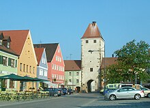
- Freystadt is a typical medieval planned town with a regular floor plan. The main feature is the market street that has been extended to the square. This is divided into the Upper and Lower Marktstrasse by the town hall built centrally on the street axis. The market street is closed off by the upper and lower gate of the medieval city wall. Both city gates are still there. Of the city wall itself there is only a small section at the upper gate, crowned by the wooden battlement.
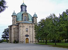
- Pilgrimage Church of Maria Hilf
nature
education
- Martini School (Elementary and Middle School)
- Burggriesbach primary school
- Primary school Möning
sons and daughters of the town
- Jean-Paul-Égide Martini (1741-1816), German-French composer
- Ernst Schweninger (1850–1924), German physician and medical historian , Bismarck's personal physician.
- Johann Baptist Lerzer (1833–1917), member of the Reichstag and Landtag
- Guntram Pflaum (1903–1945 missing), SS leader and head of Lebensborn e. V.
- Rudolf Till (1911–1979), classical philologist and professor in Munich and Erlangen
- Hanna Ludwig (1918–2014), opera singer
- Hans-Jürgen Hafner (* 1972), art critic and curator
Web links
- City administration
- Freystadt: Official statistics of the LfStat
- Literature from and about Freystadt in the catalog of the German National Library
Individual evidence
- ↑ "Data 2" sheet, Statistical Report A1200C 202041 Population of the municipalities, districts and administrative districts 1st quarter 2020 (population based on the 2011 census) ( help ).
- ^ City of Freystadt in the database of the Bavarian State Library Online . Bayerische Staatsbibliothek, accessed on December 12, 2017.
- ↑ StAAm, Seligenporten Monastery Documents, No. 195 (old signature: 1332/2/9)
- ^ Hans Rall: Wittelsbach house contracts of the late Middle Ages. (= Series of publications on Bavarian history, vol. 71), ed. v. Commission for Bavarian State History at the Bavarian Academy of Sciences, Munich 1987, p. 193.
- ^ Wilhelm Volkert (ed.): Handbook of Bavarian offices, communities and courts 1799–1980 . CH Beck, Munich 1983, ISBN 3-406-09669-7 , p. 533 .
- ^ Federal Statistical Office (ed.): Historical municipality directory for the Federal Republic of Germany. Name, border and key number changes in municipalities, counties and administrative districts from May 27, 1970 to December 31, 1982 . W. Kohlhammer GmbH, Stuttgart / Mainz 1983, ISBN 3-17-003263-1 , p. 650 .
- ↑ https://wahl.freystadt.de/Stadtratswahl/ Results of the city council election Freystadt 2020 Preliminary final result
- ↑ Result of city council election Freystadt 2014 Preliminary final result ( Memento from May 28, 2014 in the Internet Archive )
- ↑ http://www.wahlen.bayern.de/biz/kowa_g2008.php?g=h&schluessel=373&suchbegriff=3
- ↑ https://www.wahlen.bayern.de/biz/kowa_g.php?g=h&schluessel=373&suchbegriff=3
- ↑ Result of mayoral election Freystadt 2014 ( Memento from May 28, 2014 in the Internet Archive )
- ↑ Mayor election Freystadt 2020 , accessed on April 15, 2020
- ↑ Entry on the coat of arms of Freystadt in the database of the House of Bavarian History


