Pilsach
| coat of arms | Germany map | |
|---|---|---|

|
Coordinates: 49 ° 19 ' N , 11 ° 30' E |
|
| Basic data | ||
| State : | Bavaria | |
| Administrative region : | Upper Palatinate | |
| County : | Neumarkt in the Upper Palatinate | |
| Management Community : | Neumarkt in the Upper Palatinate | |
| Height : | 445 m above sea level NHN | |
| Area : | 47.65 km 2 | |
| Residents: | 2854 (Dec. 31, 2019) | |
| Population density : | 60 inhabitants per km 2 | |
| Postal code : | 92367 | |
| Area code : | 09181 | |
| License plate : | NM, PAR | |
| Community key : | 09 3 73 153 | |
| Community structure: | 27 districts | |
| Association administration address: | Bahnhofstrasse 12 92318 Neumarkt idOPf. |
|
| Website : | ||
| Mayor : | Andreas Truber ( CSU ) | |
| Location of the municipality of Pilsach in the Neumarkt district in the Upper Palatinate | ||
Pilsach is a municipality in the Upper Palatinate district of Neumarkt in the Upper Palatinate and a member of the administrative community Neumarkt in the Upper Palatinate .
geography
Geographical location
The village of Pilsach is located in the Upper Palatinate Jura , the Upper Palatinate part of the Franconian Alb, also known as the Franconian Jura . It is located in the Pilsach valley, which flows through the community and flows into the Schwarzach north of Neumarkt . The Ottenberg rises to the west .
Community structure
Pilsach has 27 officially named municipal parts :
There are the following districts : Dietkirchen, Laaber, Litzlohe, Oberwiesenacker , Pfeffertshofen, Pilsach.
history
Until the church is planted
Pilsach belonged to the Amberg Rent Office and the Pfaffenhofen Regional Court of the Electorate of Bavaria . The Lords of Orban owned an open court market here . In the course of the administrative reforms in Bavaria , today's municipality was created with the municipal edict of 1818 .
Incorporations
On July 1, 1972, the previously independent communities Litzlohe and Pfeffertshofen were incorporated. On January 1, 1978 Dietkirchen and Laaber were added. The smaller part of the dissolved municipality of Oberwiesenacker followed on May 1, 1978.
Population development
Between 1988 and 2018, the municipality grew from 2230 to 2802 inhabitants or by 25.7%.
politics
Municipal council
Since the last local election on March 15, 2020 with a voter turnout of 76.4%, the local council has consisted of seven councilors from the CSU, 5 councilors from the group “Christian voter community / free voters” and 2 councilors from the Pilsach citizens' list.
coat of arms
Blazon: In gold over two diagonally crossed black scatter forks, a red crowned and red armored half black lion with a red sword through throat and head.
The coat of arms has been used since 1978.
Attractions
- Pilsach Castle (one of those castles where Kaspar Hauser was supposedly imprisoned in his childhood and youth)
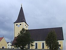
- Fortified church of St. Peter and Paul
- Cemetery in Dietkirchen (instead of tombstones, only wrought-iron crosses are used in the cemetery, which is planted with roses).
- Wind power plants near Laaber
Wind farm
Three REpower 3.2M114 wind turbines with a hub height of 143 m and a rotor diameter of 114 m are under construction.
Sons and daughters
- Johann Baptist Lehner (1890–1971), priest, local researcher and diocesan archivist in Regensburg, was born in Litzlohe.
- Ludwig Rudolf von Senft zu Pilsach (1681–1718), Saxon legation councilor, cathedral provost and hymn poet
- Carina Dengler (* 1994), German actress and singer
Individual evidence
- ↑ "Data 2" sheet, Statistical Report A1200C 202041 Population of the municipalities, districts and administrative districts 1st quarter 2020 (population based on the 2011 census) ( help ).
- ^ Community of Pilsach in the local database of the Bavarian State Library Online . Bayerische Staatsbibliothek, accessed on May 26, 2020.
- ^ Wilhelm Volkert (ed.): Handbook of Bavarian offices, communities and courts 1799–1980 . CH Beck, Munich 1983, ISBN 3-406-09669-7 , p. 533 .
- ^ Federal Statistical Office (ed.): Historical municipality directory for the Federal Republic of Germany. Name, border and key number changes in municipalities, counties and administrative districts from May 27, 1970 to December 31, 1982 . W. Kohlhammer GmbH, Stuttgart / Mainz 1983, ISBN 3-17-003263-1 , p. 649 and 650 .
- ^ Bavarian State Office for Statistics
Web links
- Entry on the coat of arms of Pilsach in the database of the House of Bavarian History


