
Sengenthal
| coat of arms | Germany map | |
|---|---|---|

|
Coordinates: 49 ° 14 ' N , 11 ° 28' E |
|
| Basic data | ||
| State : | Bavaria | |
| Administrative region : | Upper Palatinate | |
| County : | Neumarkt in the Upper Palatinate | |
| Management Community : | Neumarkt in the Upper Palatinate | |
| Height : | 434 m above sea level NHN | |
| Area : | 28.52 km 2 | |
| Residents: | 3735 (Dec. 31, 2019) | |
| Population density : | 131 inhabitants per km 2 | |
| Postal code : | 92369 | |
| Area code : | 09181 | |
| License plate : | NM, PAR | |
| Community key : | 09 3 73 159 | |
| LOCODE : | DE SGB | |
| Community structure: | 21 districts | |
| Association administration address: | Bahnhofstrasse 12 92318 Neumarkt idOPf. |
|
| Website : | ||
| Mayor : | Werner Brandenburger (FWG / UWG) | |
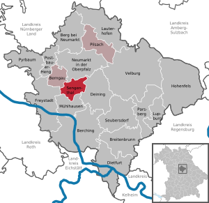
| Location of the municipality of Sengenthal in the Neumarkt district in the Upper Palatinate | ||
  |
||


Sengenthal is a municipality in the Upper Palatinate district of Neumarkt in der Oberpfalz and a member of the administrative community Neumarkt in der Oberpfalz .
geography
Geographical location
The municipality of Sengenthal is located south of Neumarkt , on the western rise to the Upper Palatinate Jura of the Franconian Alb .
Community structure
Sengenthal has 21 districts:
The districts are Forst, Reichertshofen, Sengenthal and Stauf.
history


In the 13th century, Sengenthal and Forst were still part of the imperial Hofmark Berngau , which came to the Wittelsbachers after the death of the last Staufer Konradin.
In Reichertshofen, on the other hand, a family of servants from the Reichsministerial von Stein resided. The Reichertshofers, who are mentioned in a document between 1315 and 1424, had their property in fiefdom . After the Reichertshofers died out, fiefdom was transferred to the von Wolfstein family , while the team and subordination remained electoral. The inclined beam with the three stars in the coat of arms of the municipality of Sengenthal was taken from the coat of arms of the Reichertshofer.
With the formation of the Reichertshofen parish 125 years ago (previously at the Berngau parish), a connection corresponding to today's parish was created for the first time between the places of the parish of Sengenthal, which at that time was reinforced by a school district Reichertshofen, Buchberg and Sengenthal with school headquarters in Reichertshofen. Significant changes in today's municipal area did not occur until after 1945. Due to the industrialization (construction and building materials industry) and the rail connection, the population of the municipality of Sengenthal rose from 900 in 1939 to over 3500 in the 2010s. In addition, there was a major structural change.
In Sengenthal there is a primary school for children from the municipality and a Catholic kindergarten.
Incorporations
On January 1, 1972, the previously independent communities of Forst and Reichertshofen were incorporated. On July 1, 1972, the Buchberg district of the dissolved community of Stauf (now the city of Neumarkt ) was added.
Population development
Between 1988 and 2018 the municipality grew from 2,022 to 3,621 by 1,599 inhabitants or 79.1% - the highest percentage increase in the district in the period mentioned.
politics
Municipal council
The municipal council has 14 members. The administration takes place from Neumarkt (see: Verwaltungsgemeinschaft Neumarkt in der Oberpfalz ), but municipal council meetings and an office of the mayor are in Sengenthal itself.
coat of arms
Blazon : "In black over a growing silver natural rock mountain, a golden inclined bar, covered with three six-pointed black stars."
The coat of arms has been used since 1978.
Economy and connection
economy
- In the municipality, near Greißelbach , is the headquarters of the Max Bögl construction company with the test track of the TSB magnetic levitation train .
- The most powerful wind turbine in Bavaria on the Winnberg (108 m high) in the form of a REPower 3.4M104 with 128 m hub height and 104 m rotor diameter
- Georg Behringer KG produced Portland cement in a large cement plant until 1986 .
Connection
The federal road 299 leads from the north in the direction of Neumarkt to the south in the direction of Mühlhausen through the municipality. Furthermore, the Nuremberg – Regensburg railway runs through part of the municipality.
Former traffic routes are the Ludwig Canal with a lock in the municipality and the Neumarkt – Dietfurt railway line, which was abandoned in 1991 and which now serves as the company connection for the Max Bögl construction company.
Attractions
Churches
- Parish church of St. Nikolaus in Reichertshofen
- The modern branch church in Sengenthal

- St. Georg chapel in the Winnberg district
Architectural monuments
Excursion destinations
- Abandoned Jura quarry of a former cement factory with fossils and fossils
- The Buchberg offers numerous hiking trails, including the legendary Teufelskeller, where a car filled with gold is supposed to be. On the mountain there are prehistoric fortifications (so-called Celtic entrenchments ).
- A quarry pond (sand pit) on federal road 299 near the Greißelbach district offers bathing and relaxation opportunities in summer.
- Bike tours: Sengenthaler Rundtour, In Land der Zeugenberge and Erlebnis Kanal
- The Ludwig-Danube-Main Canal is ideal for fishing and cycling
- Remains of the former Sulztalbahn and the historic station building in Greißelbach
- Neumarkt sand dunes nature reserve
Personalities
- Ludwig Körner (1915–2012), Roman Catholic pastor, first dean of the Eichstätt deanery, honorary citizen of Dollnstein and holder of the gold medal in Sengenthal
Individual evidence
- ↑ "Data 2" sheet, Statistical Report A1200C 202041 Population of the municipalities, districts and administrative districts 1st quarter 2020 (population based on the 2011 census) ( help ).
- ↑ http://www.bayerische-landesbibliothek-online.de/orte/ortssuche_action.html ? Anzeige=voll&modus=automat&tempus=+20111104/202212&attr=OBJ&val= 961
- ^ Wilhelm Volkert (ed.): Handbook of Bavarian offices, communities and courts 1799–1980 . CH Beck, Munich 1983, ISBN 3-406-09669-7 , p. 533 .
- ^ Ludwig Körner passed away , neumarktonline.de, December 31, 2012
Web links
- Entry on the coat of arms of Sengenthal in the database of the House of Bavarian History

Berching | Berg near Neumarkt in the Upper Palatinate | Berngau | Breitenbrunn | Deining | Dietfurt an der Altmühl | Freystadt | Hohenfels | Lauterhofen | Lupburg | Mulhouse | Neumarkt in the Upper Palatinate | Parsberg | Pilsach | Postbauer-Heng | Pyrbaum | Sengenthal | Seubersdorf in the Upper Palatinate | Velburg
Birch mill | Braunmühle | Braunshof | Buchberg | Dietlhof | Forest | Gollermühle | Greißelbach train station | Box mill | Oil Cake Mill | Reichertshofen | Richthof | Schlierferhaide | Schlierfermühle | Schmidmühle | Seitzermühle | Sengenthal | Sengenthal am Anger | Stadlhof | Weichselstein | Winnberg