Weichselstein
|
Weichselstein
Community Sengenthal
Coordinates: 49 ° 14 ′ 41 ″ N , 11 ° 28 ′ 37 ″ E
|
|
|---|---|
| Height : | 448 m above sea level NHN |
| Residents : | 9 (1987) |
| Incorporation : | 1820 |
| Postal code : | 92369 |
| Area code : | 09181 |
Weichselstein is a district of the municipality of Sengenthal in the Neumarkt district in Upper Palatinate in Bavaria .
location
The hamlet is around 448 m above sea level. NHN south of Neumarkt on the edge of the Neumarkt basin.
history
The “Urbarium Baiuarium Transdanubiae”, written around 1280, shows that the Bavarian dukes in Weichselstein owned three hubs and one tithe . In 1340 a Konrad der Weichselsteiner can be traced, who was a judge in Berngau . Later owners of Weichselstein were the noble families Rossraben and Parsten . At the end of the Old Kingdom , in 1800, Weichselstein consisted of two half-courts (Mayer and Grossmann) of the Lower Hofmark Berngau and was under high court the Duke of baierischen office of mayor Neumarkt .
In the new Kingdom of Bavaria (1806), Weichselstein was assigned to the Volksbach tax district formed between 1810 and 1820 . With the municipal edict of 1818, the rural community Sengenthal was formed, which also belonged to Weichselstein, which in 1836 consisted of four houses. Ecclesiastically the hamlet belonged to the parish of St. John the Baptist Neumarkt. In 1836 a gun hammer from Weichselstein is also mentioned.
According to the census of December 1, 1875, the hamlet consisted of nine buildings with twelve inhabitants at that time; there were two horses and 21 head of cattle.
Population numbers
- 1830: 25 (3 houses)
- 1836: 27 (4 houses)
- 1867: 16 (8 buildings)
- 1875: 12 (9 buildings)
- 1900: 16 (2 residential buildings)
- 1938: 18
- 1961: 12 (3 residential buildings)
- 1987: 9 (3 residential buildings, 3 apartments)
Architectural monuments
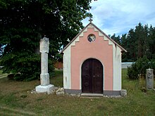
The field chapel of St. Maria, built in 1863 by Michael Feßmann, the wayside shrine "White Martyr", a four-sided figure tabernacle on a high eight-sided pillar from 1480 with the depiction of the crucifixion of Christ and, on the back, the presentation of the handkerchief of Veronica, a stone stadel from the 18th century Century and a home of a former farm from 1665 and 1793 are considered architectural monuments.
See also the list of architectural monuments in Sengenthal # Weichselstein
traffic
From Sengenthal a community road leads to the northeast to Weichselstein and from there to the north to Neumarkt- Lähr .
literature
- Franz Xaver Buchner : The diocese of Eichstätt. Volume I and II, Eichstätt: Brönner & Däntler, 1937 and 1938
- Bernhard Heinloth: Historical Atlas of Bavaria. Part Altbayern, Issue 16: Neumarkt , Munich: Commission for Bavarian State History, 1967
- Rudi Bayerl : The “White Torture” gave a mountain its name. In: Schönere Heimat , 98 (2009), 2, Bayerischer Landesverein für Heimatpflege eV, Munich 2009, pp. 74–75.
Individual evidence
- ↑ Heinloth, p. 213 f.
- ^ Johann Nepomuk von Löwenthal: History of the Schultheißenamt and the city of Neumarkt on the Nordgau or in today's Upper Palatinate , Munich: Zwingl'sche Schriften, 1805, p. 39; Repertory of the topographical atlas sheet. Neumarkt , 1836, p. 108
- ↑ Heinloth, p. 287
- ↑ Heinloth, p. 329; Popp, p. 120
- ^ Repertory of the topographical atlas sheet. Neumarkt , 1836, p. 33
- ↑ Kgl. Statistical Bureau in Munich (edit.): Complete list of localities of the Kingdom of Bavaria ... based on the results of the census of December 1st. 1875 , Munich 1876, column 886
- ^ Karl Friedrich Hohn: The rain district of the Kingdom of Bavaria, described geographically and statistically , Stuttgart and Tübingen: Cotta, 1830, p. 144
- ↑ Popp, Th. D. (ed.): Matrikel des Bissthumes Eichstätt , Eichstätt: Ph. Brönner, 1836, p. 120
- ^ Joseph Heyberger: Topographical-statistical handbook of the Kingdom of Bavaria with an alphabetical local dictionary , Munich 1867, column 710
- ↑ Complete list of localities of the Kingdom of Bavaria ... based on the results of the census of December 1st. 1875 , column 886
- ^ Localities directory of the Kingdom of Bavaria ... [based on the results of the census of December 1, 1900] , column 869
- ↑ Buchner II, p. 258
- ^ Official register of places for Bavaria. Territorial status on October 1, 1964 with statistical information from the 1961 census , Munich 1964, column 553
- ↑ Official directory for Bavaria, territorial status: May 25, 1987 , Munich 1991, p. 260
- ↑ Buchner II, p. 254
- ↑ Buchner II, p. 261
- ^ Sixtus Lampl and Otto Braasch: Monuments in Bavaria, Volume III: Upper Palatinate. Ensembles, architectural monuments, archaeological site monuments, Munich: R. Oldenbourg Verlag, 1986, p. 159
-
^ Friedrich Hermann Hofmann and Felix Mader (arrangement), Die Kunstdenkmäler von Oberpfalz & Regensburg, Booklet XVII, Stadt und Bezirksamt Neumarkt , Munich: R. Oldenbourg Verlag, 1909, p. 289.
 online on commons

