
Parsberg
| coat of arms | Germany map | |
|---|---|---|

|
Coordinates: 49 ° 9 ' N , 11 ° 43' E |
|
| Basic data | ||
| State : | Bavaria | |
| Administrative region : | Upper Palatinate | |
| County : | Neumarkt in the Upper Palatinate | |
| Height : | 553 m above sea level NHN | |
| Area : | 57.33 km 2 | |
| Residents: | 7292 (Dec. 31, 2019) | |
| Population density : | 127 inhabitants per km 2 | |
| Postal code : | 92331 | |
| Area code : | 09492 | |
| License plate : | NM, PAR | |
| Community key : | 09 3 73 151 | |
| LOCODE : | DE PAR | |
| City structure: | 34 districts | |
City administration address : |
Alte Seer Strasse 2 92331 Parsberg |
|
| Website : | ||
| Mayor : | Josef Bauer ( CSU ) | |
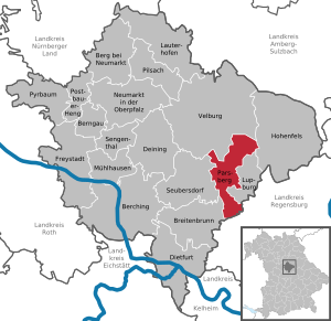
| Location of the town of Parsberg in the Neumarkt district in the Upper Palatinate | ||
  |
||

Parsberg is the fourth largest city in the Upper Palatinate district of Neumarkt in the Upper Palatinate .

geography
Geographical location
The city of Parsberg is located between the cities of Regensburg and Neumarkt in the valley of the Schwarzen Laber . The city's topography shows great differences in altitude and the lively landscape is known as the Kuppenalb .
geology
The White Jura (Malm) is the defining geological group in Parsberg. Formations of marl, limestone and dolomite stone shape the diverse hilly landscape. The valley of the Schwarzen Laber has cut deeply into the rocks of the White Jura. Corrugated limestone, which appear as white and rugged Jurassic rocks, are the result of karstification that has taken place.
A small peculiarity is the appearance of sinkholes in the woods of Parsberg. These funnel-shaped terrain forms have developed from sinkholes, as a result of corrosion or washout, as well as subsidence of surface layers in underground cavities.
climate
With its humid climate, Parsberg is located in the cool, temperate climate zone . The city is located in the transition area between the humid Atlantic and the dry continental climate . According to the Köppen-Geiger climate classification, Parsberg belongs to the warm, temperate rainy climate (Cfb climate). The mean air temperature of the warmest month remains below 22 ° C and that of the coldest month above -3 ° C.
The average annual rainfall is 740 mm, with an overweight in summer. June is the wettest month with 89 mm. The month with the lowest rainfall is February with 43 mm. The average temperature over the entire year is 7.5 ° C. From a climatological point of view, July is the warmest month of the year with an average of 16.8 ° C. The lowest temperatures are recorded in January with an average of −2.4 ° C.
|
Average monthly temperatures and rainfall for Parsberg
Source: Climate-Data
|
|||||||||||||||||||||||||||||||||||||||||||||||||||||||||||||||||||||||||||||||||||||||||||||||||||||||||||||||||||||||||||||||||||||||||||||||||||||||||||||||||||||
Waters
The city area is traversed by the meandering Schwarzen Laber in an east-west direction. The natural course of the river is designed as a representative valley train of the Franconian Jura and divides the urban area into a northern and southern part. The Frauenbach is a left tributary and the Kerschhofener Bach is a right tributary of the Schwarzen Laber in Parsberg.
City structure
Parsberg has 34 districts:
Neighboring communities
Neighboring municipalities are (starting in the north in a clockwise direction):
Velburg , Hohenfels , Lupburg , Hemau , Breitenbrunn and Seubersdorf in the Upper Palatinate .
history
Parsberg was first mentioned in 1205 as "Castrum Bartesperch". A mention in the year 933 ("Rüxner'sches Thuernierbuch") is very likely wrong. Probably in 1315 the first Parsberg castle was razed after a brief siege by Duke Ludwig of Bavaria . This was followed by a reconstruction with a significant expansion of the castle complex around 1450. In 1571 almost all the houses in Parsberg, with the exception of the castle and the church, were destroyed by a fire. Destruction of the castle by the Swedes in 1632/33 during the Thirty Years' War is rather unlikely. After 1648, the Parsberg knights no longer had the necessary means for a reconstruction to the current state (since 1600). The last of the Bavarian family of the Lords of Parsberg, Johann Wolfgang von Parsberg, dies on May 7th, 1730. There are descendants in Denmark (Pasbjerg), the USA and Belgium (de Partz de Courtray). The rule of Parsberg passed to the Counts of Schönborn in 1734 . In 1792, Elector Karl Theodor bought the imperial rule until it was incorporated into the Electorate of Bavaria in 1803.
In 1841 the market burned down again to a large extent. In the old center within the market walls, 62 houses, including all baker's, inn and butcher's houses, burned down, only 40 houses were spared. With the construction of the railway in 1872, the Parsberg market began to flourish. The district offices of Velburg and Hemau were merged into the district office of Parsberg on October 1, 1879. The district office was relocated from Velburg to Parsberg after the official building was completed in 1880. In 1952, the Parsberg market was given the name Stadt .
Incorporations
On January 1, 1971, the previously independent community of Rudenshofen was incorporated. On July 1, 1971, Darshofen was added. Herrnried and Willenhofen as well as parts of the dissolved communities Ronsolden and See were added on January 1, 1972. Hörmannsdorf and parts of the dissolved municipality of Degerndorf followed on May 1, 1978.
Administrative community
From May 1, 1978 to December 31, 2001, the town of Parsberg and the market town of Lupburg formed the administrative community . Both municipalities have been self-governing again since 2002.
Population development
1840 to 1987
With the beginning of industrialization, the population growth in Parsberg increased. While 2135 people lived in the city in 1840, the population grew to 5619 in 1987.
| year | 1840 | 1871 | 1900 | 1925 | 1939 | 1950 | 1961 | 1970 | 1987 |
|---|---|---|---|---|---|---|---|---|---|
| population | 2135 | 3154 | 2935 | 3166 | 3396 | 4525 | 4678 | 5369 | 5619 |
Source: Bavarian State Office for Statistics
From 2005
From 2005 the population stagnated. Moderate population growth can only be observed from 2012 onwards.
| year | 2005 | 2006 | 2007 | 2008 | 2009 | 2010 | 2011 | 2012 | 2013 | 2014 | 2015 | 2016 | 2017 | 2018 |
|---|---|---|---|---|---|---|---|---|---|---|---|---|---|---|
| population | 6526 | 6472 | 6521 | 6561 | 6601 | 6583 | 6569 | 6593 | 6630 | 6731 | 6771 | 6955 | 7046 | 7200 |
Source: Bavarian State Office for Statistics
Between 1988 and 2018 the city grew from 5,701 to 7,213 by 1,512 inhabitants or by 26.5%.
politics
City council
The 20 seats of the city council are distributed among the individual parties and groups as follows:
|
|
mayor
Josef Bauer (CSU) has been 1st Mayor of the city of Parsberg since 2002. In the 2020 local elections, he was confirmed in office with 50.3 percent of the valid votes. Its competitors received 24.5%, 17.7% and 7.5% of the vote.
household
The total volume of the budget of the city of Parsberg in 2015 was around 24.3 million euros; the debt level as of December 31, 2014 was 1.562 million euros. The income from trade tax in 2014 amounted to around 2.6 million euros, the amount of income tax participation in the 2014 financial statements was 2.925 million euros.
coat of arms
Blazon: Divided; red above, split by black and silver below.
The coat of arms resembles the shield and family coat of arms of the old Bavarian noble family of the Parsbergs. Markt Parsberg was granted the right to its own coat of arms by the royal decree of King Maximilian I Joseph on June 23, 1813.
At times, blue was used as the field color for the upper half of the shield of the coat of arms, in order to document the Bavarian affiliation. In 1950 the coat of arms was changed again in accordance with the shield of the old Parsbergs.
Town twinning
![]() Vic-le-Comte , Auvergne-Rhône-Alpes ( France ), since 1987
Vic-le-Comte , Auvergne-Rhône-Alpes ( France ), since 1987
Culture and sights
Museums
- The Parsberg Castle Museum includes folklore and local history collections. It emerged from the acquisition and amalgamation of the collections of two deceased teachers and collectors (main teacher Spörer from Hohenburg and senior teacher Singer from Parsberg). In 2007 the museum was expanded to include a contemporary history section, which depicts the time between the Bismarck era and the end of the Second World War and shows both regional and supra-regional aspects.
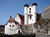
Parsberg Castle above the city

St. Andreas and Parsberg Castle
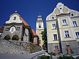
St. Andrew's Church and Catholic rectory


Buildings
- The Parsberg Castle on the "Burgberg" was the seat of the Parsberg noble family until it went out in 1730 .
Protected areas
In Parsberg, 311 hectares are designated as the Parsberg landscape protection area.
In addition, parts of the 1159 hectare Natura 2000 area Schwarze Laaber (FFH area) are located in the urban area.
Cultural landscape
The Kuppenalb around Parsberg and Velburg represents a cultural landscape that is important throughout Bavaria due to the clearly recognizable landscape characteristics.
The Jura landscape, including the valley landscape of the Schwarzen Laber with the mostly open, grassland floodplains and the partly large-scale poor and dry grasslands on the slopes is of high cultural landscape value. The historical settlement structures, which are characterized by hamlets and small clustered villages, give the area a special character.
Historical cultural landscape elements in the urban area are also:
- Parsberg Castle,
- sacred buildings that are effective in the landscape, such as the parish church of St. Andreas in Parsberg and the parish church of St. Mauritius in Willenhofen as well
- historical building fabric with pitched roof constructions (based on the Middle Franconian half-timbered construction).
Sports
- Jura-Mare wave swimming pool
- Indoor swimming pool
- six gyms
Economy and Infrastructure
traffic
Parsberg is on the federal highway 3 Nuremberg - Regensburg (exit 94), in the immediate vicinity of the federal road 8 Neumarkt - Regensburg . Parsberg RE station is on the main railway line from Nuremberg to Regensburg . An extension of the S3 line of the Nuremberg S-Bahn from Neumarkt to Parsberg is not actively pursued for the time being due to the questionable economy.
Specialist clinics
Parsberg is known nationwide for its specialist hospital for tuberculosis treatment with an outbreak-proof isolation ward and is unique for the Federal Republic of Germany.
There is also a clinic for forensic psychiatry and psychotherapy and a specialist clinic for young drug addicts in Parsberg .
education
- Elementary and middle school
- Edith-Stein Realschule
- Parsberg high school
- Special educational support center
sons and daughters of the town
- Johann Baptist Hierl (1856–1936), auxiliary bishop in Regensburg.
- Konstantin Hierl (1875–1955), Reich Labor Leader of the Reich Labor Service
- Maximilian Siry (1891–1967), Lieutenant General in World War II
- Alfred Spitzner (1921–1992), politician ( CSU ), district assembly president of the Upper Palatinate
- Josef Eibl (1936–2018), civil engineer
- Ludwig Stiegler (* 1944), politician ( SPD )
- Wolfgang M. Heckl (* 1958), General Director of the Deutsches Museum in Munich
- Albert Füracker (* 1968), Bavarian Minister of Finance and Home Affairs
- Ünsal Arik (* 1980), boxer
Individual evidence
- ↑ "Data 2" sheet, Statistical Report A1200C 202041 Population of the municipalities, districts and administrative districts 1st quarter 2020 (population based on the 2011 census) ( help ).
- ^ Archives Burgmuseum Parsberg
- ↑ The BayernAtlas - the map viewer of the Free State of Bavaria with maps, aerial photos and a variety of themed maps. Bavarian Surveying Administration, accessed on September 1, 2017 .
- ↑ Hazard warning map Jura rockfall-landslide-sinkhole district Neumarkt in the Upper Palatinate. Bavarian State Office for the Environment (LfU), July 2015, accessed on September 1, 2017 .
- ↑ Climate & weather in Parsberg. AM Online Projects, accessed October 2, 2017 .
- ↑ Climate-Data.org
- ↑ http://www.bayerische-landesbibliothek-online.de/orte/ortssuche_action.html ? Anzeige=voll&modus=automat&tempus=+20111104/194806&attr=OBJ&val= 957
- ↑ Parsberger Chronik on www.parsberg.de
- ^ Wilhelm Volkert (ed.): Handbook of Bavarian offices, communities and courts 1799–1980 . CH Beck, Munich 1983, ISBN 3-406-09669-7 , p. 547 .
- ^ Federal Statistical Office (ed.): Historical municipality directory for the Federal Republic of Germany. Name, border and key number changes in municipalities, counties and administrative districts from May 27, 1970 to December 31, 1982 . W. Kohlhammer GmbH, Stuttgart / Mainz 1983, ISBN 3-17-003263-1 , p. 650 .
- ^ Dissolution by the Sixth Act to Change the Structure of Municipalities and Administrative Communities of November 23, 2001 ( GVBl p. 738)
- ↑ a b Municipal statistics 2015: City of Parsberg. Bavarian State Office for Statistics, 2015, accessed on October 10, 2017 .
- ↑ Parsberg city council election on March 15, 2020, official final result , accessed on April 16, 2020
- ↑ Mayor "very satisfied". Neumarkter Nachrichten, February 4, 2011, accessed on September 1, 2017 .
- ↑ Parsberger Stadtblatt 2/2020, p. 8
- ↑ Günterreiber: Bauer: "Household is a healthy basis" . In: Mittelbayerische.de and print edition Neumarkter Tagblatt of May 6, 2015 p. 47 . May 5, 2015. Retrieved May 6, 2015.
- ↑ Bavaria's municipalities: coat of arms, history, geography. Bavarian State Ministry for Education and Culture, Science and Art, accessed on September 1, 2017 .
- ↑ Website Parsberg ( Memento of the original from June 30, 2016 in the Internet Archive ) Info: The archive link was inserted automatically and has not yet been checked. Please check the original and archive link according to the instructions and then remove this notice.
- ↑ Green List of Landscape Protection Areas in Bavaria. Bavarian State Office for the Environment (LfU), July 15, 2016, accessed on September 1, 2017 .
- ↑ 6836-371 Schwarze Laaber (FFH area). Published by the Federal Agency for Nature Conservation . Retrieved February 5, 2019.
- ↑ a b Cultural landscape recommendations for Bavaria: 27 Oberpfälzer Alb. Bavarian State Office for the Environment (LfU), 2013, accessed on September 1, 2017 .
- ↑ City Parsgerg - Facts and figures . Website www.parsberg.de. Retrieved April 7, 2015.
- ↑ nordbayern.de, Nuremberg, Germany: The signal is on the Neumarkt Süd S-Bahn stop . ( nordbayern.de [accessed on January 3, 2018]).
- ↑ medbo district hospital Parsberg - clinic for pulmonary and bronchial medicine . In: medbo.de . Retrieved May 14, 2019.
- ↑ Clinic for Forensic Psychiatry and Psychotherapy . In: medbo.de . Retrieved May 14, 2019.
- ^ Lothar Röhrl: Albert Füracker is now finance minister. In: Mittelbayerische. Mittelbayerische, March 21, 2018, accessed March 30, 2020 .
Web links
- Entry on the coat of arms of Parsberg in the database of the House of Bavarian History

Berching | Berg near Neumarkt in the Upper Palatinate | Berngau | Breitenbrunn | Deining | Dietfurt an der Altmühl | Freystadt | Hohenfels | Lauterhofen | Lupburg | Mulhouse | Neumarkt in the Upper Palatinate | Parsberg | Pilsach | Postbauer-Heng | Pyrbaum | Sengenthal | Seubersdorf in the Upper Palatinate | Velburg
Badelhütte | Bienmühle | Bow mill | Breitenthal | Christlmühle | Darshofen | Eglwang | Eichensee | Geigerhaid | Hackenhofen | Haid | Hammer mill | Herrnried | Holzheim | Hörmannsdorf | Katzenfels | Kellerhof | Kerschhofen | Klapfenberg | Kripfling | Kühnhausen | Lohhof | Mannsdorf | Neuhaid | Oedenthurn | Parsberg (core town) | Upholstery mill | Rosenthal | Rudenshofen | Rudolfshöhe | Stone mill | Weiherstetten | Willenhofen | Wolf squiga