Michelbach (Freystadt)
|
Michelbach
City of Freystadt
Coordinates: 49 ° 11 ′ 12 ″ N , 11 ° 18 ′ 20 ″ E
|
|
|---|---|
| Height : | 410 m above sea level NHN |
| Area : | 4.41 km² |
| Residents : | 160 (December 31, 2016) |
| Population density : | 36 inhabitants / km² |
| Incorporation : | July 1, 1972 |
| Postal code : | 92342 |
| Area code : | 09179 |
|
Michelbach
|
|
Michelbach is a former municipality and since the regional reform in Bavaria has been part of the town of Freystadt in the Neumarkt district in Upper Palatinate in Bavaria .
location
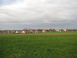
The village is located in the Frankenalb on the Jura plateau at 410 m above sea level. NHN . The center of the town is about 100 meters north of the Main-Danube Canal and about two kilometers southwest of the town's headquarters. The local corridor covers 255 hectares .
history
"Michilinbach" is first mentioned in 1188 when Bishop Otto von Eichstätt built the altar of his Magdalenenkapelle in his cathedral church and furnished it with goods from Michelbach. In the 13th century, several local nobility are documented: 1217 an Ulrich de Michilnbach, 1235 a Ludewicus de Michelbach, 1256 a Henricus de Michelnbach. In 1486 one hears about the possession of the Wolfsteiner in Michelbach. In the 16th century, Michelbach consisted of 16 farms, six of which belonged to the Eichstätt monastery , four to the Stein rule , another four to the Nuremberg alms office , two to the parish of Heuberg and one of the Oelhafen benefices.
Towards the end of the Old Kingdom , around 1800, Michelbach consisted of 23 subject properties of different sizes, which were subordinate to eight different manors and offices: One property each belonged to the Mörsdorf church, the Eichstätt cathedral chapter , the Sulzbürg electoral-Bavarian office and the Nuremberg Holzschuher family foundation ; two properties were owned by the parish Hilpoltstein / Mörlach church ; The Seligenporten Monastery and the Protestant Cultural Foundation Nuremberg each had three subject properties; nine subject properties belonged to the Hilpoltstein Rent Office and two were freely owned . The high jurisdiction exercised the Pflegamt from Hilpoltstein.
In the new Kingdom of Bavaria (1806), the Mörsdorf tax district was formed in the Hilpoltstein district court and rent office in what was later to be Middle Franconia , to which Michelbach belonged. With the community edict of 1818, the community Michelbach was formed, to which the village of Michelbach and the three wastelands Rothenhof , Rumleshof and Schöllnhof were assigned. All four settlements belonged to the parish Meckenhausen ; In 1872, however, Rothenhof and Schöllnhof were parried to Freystadt. In 1875 the farmers in Michelbach had nine horses and 184 cattle; According to official census, there were 21 horses, 260 cattle, 60 sheep, 121 pigs and three goats in the entire municipality. 25 years later there were 25 horses, 252 cattle, 135 pigs and four goats in the community.
With the regional reform in Bavaria , this community was spun off from the Middle Franconian district of Hilpoltstein and incorporated into the town of Freystadt in the district of Neumarkt in the Upper Palatinate on July 1, 1972. The land consolidation was carried out from 1963 to 1973 . A hall cross reminds of them .
Population development in the village of Michelbach
- 1820: 134 (23 houses)
- 1871: 121 (40 buildings)
- 1900: 130 (22 residential buildings)
- 1938: 111
- 1950: 134 (23 houses)
- 1961: 132 (24 residential buildings)
- 1973: 142
- December 31, 2016: 160
Population of the community of Michelbach (area: 441 hectares)
- 1871: 162 (all Catholic) (52 buildings, 29 residential buildings)
- 1900: 174 (all Catholic) (29 residential buildings)
- 1961: 177 (33 residential buildings)
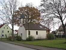
Local Catholic chapel
This was built in 1891 by the municipality; from 1922 the chaplain of Meckenhausen was allowed to read mass here. The roof turret contained a bell from 1891 in 1938.
Transport links
Michelbach is located immediately to the east of State Road 2238 between the municipal seat of Freystadt and Meckenhausen. At the southern end of Michelbach, State Road 2238 crosses the Main-Danube Canal in the direction of Meckenhausen. Communal roads lead from Michelbach in an easterly direction to Ohausen and in a northwesterly direction to Mörsdorf.
societies
- Volunteer firefighter
- Fruit and horticultural association
- Association for custom and home care Michelbocha eV
literature
- Franz Xaver Buchner : The diocese of Eichstätt. Volume I: Eichstätt 1937, Volume II: Eichstätt 1938
- Wolfgang Wiessner: Hilpoltstein . In: Commission for Bavarian State History at the Bavarian Academy of Sciences (Hrsg.): Historical Atlas of Bavaria . Part Franconia, Series I, Issue 24. Munich 1978, ISBN 3-7696-9908-4 ( digitized version ).
Individual evidence
- ↑ a b c Bavarian State Statistical Office (ed.): Official city directory for Bavaria, territorial status on October 1, 1964 with statistical information from the 1961 census . Issue 260 of the articles on Bavaria's statistics. Munich 1964, DNB 453660959 , Section II, Sp. 797 ( digitized version ).
- ^ Wolfgang Wiessner: Hilpoltstein . In: Commission for Bavarian State History at the Bavarian Academy of Sciences (Hrsg.): Historical Atlas of Bavaria . Part Franconia, Series I, Issue 24. Munich 1978, ISBN 3-7696-9908-4 , p. 35 ( digitized version ).
- ^ Wolfgang Wiessner: Hilpoltstein . In: Commission for Bavarian State History at the Bavarian Academy of Sciences (Hrsg.): Historical Atlas of Bavaria . Part Franconia, Series I, Issue 24. Munich 1978, ISBN 3-7696-9908-4 , p. 22 ( digitized version ).
- ↑ a b Wolfgang Wiessner: Hilpoltstein . In: Commission for Bavarian State History at the Bavarian Academy of Sciences (Hrsg.): Historical Atlas of Bavaria . Part Franconia, Series I, Issue 24. Munich 1978, ISBN 3-7696-9908-4 , p. 138 ( digitized version ).
- ↑ Buchner I, p. 339
- ↑ a b Wolfgang Wiessner: Hilpoltstein . In: Commission for Bavarian State History at the Bavarian Academy of Sciences (Hrsg.): Historical Atlas of Bavaria . Part Franconia, Series I, Issue 24. Munich 1978, ISBN 3-7696-9908-4 , p. 225 ( digitized version ).
- ↑ a b c d Wolfgang Wiessner: Hilpoltstein . In: Commission for Bavarian State History at the Bavarian Academy of Sciences (Hrsg.): Historical Atlas of Bavaria . Part Franconia, Series I, Issue 24. Munich 1978, ISBN 3-7696-9908-4 , p. 255 ( digitized version ).
- ↑ Buchner II, p. 118
- ↑ a b c Kgl. Statistical Bureau (ed.): Complete list of localities of the Kingdom of Bavaria. According to districts, administrative districts, court districts and municipalities, including parish, school and post office affiliation ... with an alphabetical general register containing the population according to the results of the census of December 1, 1875 . Adolf Ackermann, Munich 1877, 2nd section (population figures from 1871, cattle figures from 1873), Sp. 890 , urn : nbn: de: bvb: 12-bsb00052489-4 ( digitized version ).
- ↑ a b c K. Bayer. Statistical Bureau (Ed.): Directory of localities of the Kingdom of Bavaria, with alphabetical register of places . LXV. Issue of the contributions to the statistics of the Kingdom of Bavaria. Munich 1904, Section II, Sp. 1220 ( digitized version ).
- ^ Wilhelm Volkert (ed.): Handbook of Bavarian offices, municipalities and courts 1799–1980 , Munich 1983, p. 533
- ↑ Buchner II, p. 118
- ^ Website of the Freystadt community
- ↑ Buchner II, pp. 117-119


