Reckenstetten (Allersberg)
|
Reckenstetten
Allersberg market
Coordinates: 49 ° 14 ′ 22 " N , 11 ° 17 ′ 43" E
|
|
|---|---|
| Height : | 415 m |
| Postal code : | 90584 |
| Area code : | 09176 |
|
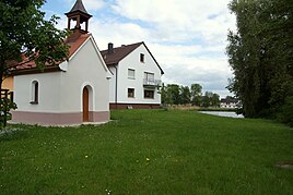
Local Catholic chapel
|
|
Reckenstetten is part of the municipality of Allersberg in the Central Franconian district of Roth in Bavaria .
Place name interpretation
The place name contains the personal name Recko.
location
The village is located at 415 meters above sea level directly on the municipal border of Allersberg and the Roth district border on the right of the Schwarzach . A smaller part of Reckenstetten lies to the left of the Schwarzach and is incorporated into the city of Freystadt .
history
In 1283 and 1286, "Rukersteten" is mentioned in connection with a transfer of ownership by Ulrich von Obersulzbürg to the Teutonic Order House in Nuremberg . It is questionable whether there was a local nobility and thus a castle. In 1360 the Eichstätt bishop gave the tithing of "Ruchkersteten" Albert von Wolfstein zu Sulzbürg as a fief. The previously Bavarian place became part of the Palatinate Neuburg in 1505 and was pledged to Nuremberg from 1542–1578. The imperial city introduced the Reformation in 1542 . The Counter Reformation was carried out in 1627 under Count Palatine Wolfgang Wilhelm . All of this also applied to Reckenstetten. In 1849 the St. Wendelin chapel was built.
Towards the end of the Old Kingdom , around 1800, Reckenstetten consisted of nine subject properties, which were subordinate to two different offices. Eight yards belonged to the Allersberg district judge and one yard to the Seligenporten monastery judge. The highest jurisdiction lay with the district court of Allersberg and the Hilpoltstein care office. The community had a shepherd's house.
In the new Kingdom of Bavaria (1806) Reckenstetten initially belonged to the municipality of Eppersdorf , then to the municipality of Ebenried in the Hilpoltstein district until the regional reform in Bavaria . With the dissolution of the Hilpoltstein district and the municipality of Ebenried, Reckenstetten was incorporated into Allersberg on January 1, 1972.
Population development
- 1820: 45 (nine properties)
- 1838: 54 (eight properties)
- 1950: 47 (ten residential buildings)
- 1973: 39
- 1987: 40 (twelve residential buildings, 13 apartments)
economy
There is a car workshop, a butcher's shop and a horse farm.
societies
Pony and horses SV Reckenstetten e. V.
Architectural monuments
In addition to the local chapel, a boundary stone in the direction of Seligenporten is considered a monument.
Transport links
Reckenstetten is on State Road 2237, which comes from Allersberg via Reckenstetten and Rohr to Freystadt. There are communal roads from Reckenstetten to Ebenried and Schwarzach.
literature
- Franz Xaver Buchner : The diocese of Eichstätt. Volume I: Eichstätt 1937, Volume II: Eichstätt 1938
- Wolfgang Wiessner: Hilpoltstein . In: Commission for Bavarian State History at the Bavarian Academy of Sciences (Hrsg.): Historical Atlas of Bavaria . Part Franconia, Series I, Issue 24. Munich 1978, ISBN 3-7696-9908-4 ( digitized version ).
- Bernhard Heinloth: Historical Atlas of Bavaria. Part Altbayern, Issue 16: Neumarkt , Munich: Commission for Bavarian State History, 1967
Individual evidence
- ^ Wolfgang Wiessner: Hilpoltstein . In: Commission for Bavarian State History at the Bavarian Academy of Sciences (Hrsg.): Historical Atlas of Bavaria . Part Franconia, Series I, Issue 24. Munich 1978, ISBN 3-7696-9908-4 , p. 15 ( digitized version ).
- ^ Wolfgang Wiessner: Hilpoltstein . In: Commission for Bavarian State History at the Bavarian Academy of Sciences (Hrsg.): Historical Atlas of Bavaria . Part Franconia, Series I, Issue 24. Munich 1978, ISBN 3-7696-9908-4 , p. 22 ( digitized version ).
- ^ Wolfgang Wiessner: Hilpoltstein . In: Commission for Bavarian State History at the Bavarian Academy of Sciences (Hrsg.): Historical Atlas of Bavaria . Part Franconia, Series I, Issue 24. Munich 1978, ISBN 3-7696-9908-4 , p. 276 ( digitized version ).
- ↑ Heinloth, p. 80
- ↑ Franz Heidingfelder ( arrangement ): The regests of the bishops of Eichstätt. Palm & Enke, Erlangen 1938, No. 749
- ↑ Buchner I, pp. 20, 223
- ^ Wolfgang Wiessner: Hilpoltstein . In: Commission for Bavarian State History at the Bavarian Academy of Sciences (Hrsg.): Historical Atlas of Bavaria . Part Franconia, Series I, Issue 24. Munich 1978, ISBN 3-7696-9908-4 , p. 230 ( digitized version ).
- ↑ Heinloth, p. 276
- ↑ a b c Wolfgang Wiessner: Hilpoltstein . In: Commission for Bavarian State History at the Bavarian Academy of Sciences (Hrsg.): Historical Atlas of Bavaria . Part Franconia, Series I, Issue 24. Munich 1978, ISBN 3-7696-9908-4 , p. 251 ( digitized version ).
- ↑ Th. D. Popp (Ed.): Register of the Bissthumes Eichstätt. Ph.Brönner, Eichstätt 1836, p. 32
- ↑ Bavarian State Office for Statistics and Data Processing (Ed.): Official local directory for Bavaria, territorial status: May 25, 1987 . Issue 450 of the articles on Bavaria's statistics. Munich November 1991, DNB 94240937X , p. 347 ( digitized version ).

