Little Roth (Roth, Eckersmühlen)
| Little Roth | ||
|
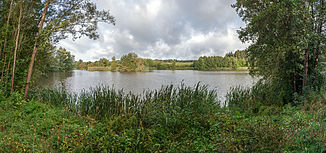
Rothsee with mouth areas of Kleiner Roth (left, back) |
||
| Data | ||
| Water code | DE : 242148 | |
| location |
Middle Franconian basin
|
|
| River system | Rhine | |
| Drain over | Roth → Rednitz → Regnitz → Main → Rhine → North Sea | |
| Confluence of the source streams | in the Middle Franconian Basin near Eppersdorf 49 ° 15 ′ 58 ″ N , 11 ° 14 ′ 49 ″ E |
|
| Source height | approx. 394 m above sea level NHN | |
| muzzle | near Eckersmühlen in the Roth coordinates: 49 ° 12 ′ 41 ″ N , 11 ° 9 ′ 10 ″ E 49 ° 12 ′ 41 ″ N , 11 ° 9 ′ 10 ″ E |
|
| Mouth height | approx. 351 m above sea level NHN | |
| Height difference | approx. 43 m | |
| Bottom slope | approx. 3.7 ‰ | |
| length | 11.8 km (with the source stream on the left) |
|
| Catchment area | 38.52 km² | |
| Drain |
MNQ MQ MHQ |
310 l / s 960 l / s 15.2 m³ / s |
| Left tributaries | see below | |
| Right tributaries | nameless tributaries | |
| Reservoirs flowed through | Rothsee | |
The Kleine Roth is a, with its left source brook, about 11.8 km long, northeast and orographically right tributary of the Roth in the Central Franconian district of Roth in Bavaria . It flows through the Rothsee and is a flowing water of the 1st and 3rd order .
geography
course
The Kleine Roth rises and runs in the Middle Franconian Basin . It has two nameless spring streams that arise in the south of the western Pyrbaumer Forest :
- The east and left source stream ( ⊙ ), which is almost one and a half kilometers long and already bears the name Kleine Roth on some maps , rises almost 600 m east-southeast of the Allersberg district of Eppersdorf in the Sauerloh forest at an altitude of 425 m above sea level. NHN . This flows through Eppersdorf and takes the treated wastewater from a sewage treatment plant as a receiving water from the right about 500 m below .
- The north and right source stream ( ⊙ ), which itself has two source arms and is around 350 m long when they join , comes from the north from the Harrhofschlag forest, which is also near the village .
The confluence (approx. 394 m ) of the two source streams is about 200 m west-southwest of the sewage treatment plant at a road bridge at a height of 395.3 m . From there on, the Kleine Roth (finally) bears her name.
About 350 m below this confluence, the Kleine Roth feeds six ponds that are used for fishing and cover an area of almost 1.5 hectares. After a further 600 m it reaches the northern edge of the core town of the market town of Allersberg , where it first takes the Langweidgraben from the left and then the Küselgraben . At the exit of the village there is also the sewage from the Allersberg sewage treatment plant and some meadow streams that only carry water temporarily.
Under the Federal Highway 9 and the Nuremberg-Munich high-speed railway through it flows 1.5 kilometers below Allersberg into the scale in the 1980s and Small Rothsee called Vorsperre of Rothsee one; this is designated as a nature reserve of the Rothsee reservoir root . In the pre-dam, the Kleine Roth mixes with the Schönbrunn Bach, which flows 150 m further southeast from the east-southeast . In the pre-barrier, the Kleine Roth then flows into the Schwarzengraben from the left . The first part of the valley is the Vorsperrendamm with a road and footpath bridge between Birkach and Kronmühle .
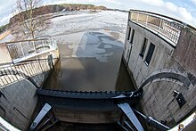
Below the 15 m high diversion structure of the Rothsee pre- dam , which belongs to the Rothsee power plants, the Kleine Roth flows through the main dam. Both in the pre-dam and in the main dam there is an inflow of about a dozen nameless, partly only temporarily water-bearing meadow ditches; the southwest area of the pre-dam and most of the main dam are used intensively for tourism and recreation.
Below the main dam, the Kleine Roth crosses under the Main-Danube Canal either in a culvert more than 500 m long, or it is wholly or partially fed into it, depending on requirements . It then follows its natural, self-indented course again from the Roth district of Haimpfarrich , now running at an altitude of 353 m , and is there as a first-order body of water. There they fed between backwaters several fish weiher .
The Kleine Roth flows 1.4 km below the Main-Danube Canal near the Roth district of Eckersmühlen with two separate arms at a height of about 351 m a little west of the Leonhardsmühle from the right into the Rednitz tributary Roth, which comes from about south there .
Catchment area and tributaries
The catchment area of the Kleine Roth is 38.52 km² . Its tributaries include, with orographic allocation (l = left-hand side, r = right-hand side; the latter only exist as nameless tributaries) and mouth (viewed downstream) :
- Langweidgraben (l; in Allersberg)
- Kieselgraben (l; in Allersberg)
- Schönbrunner Bach (l; in the Rothsee pre-dam - close influence of the Little Roth)
Hydrology
The average bulk Kleine Roth is at its discharge from the Lake Roth, after the evaporative discounts, and the addition of any of precipitation, about 10 million cubic meters annually. The drain can about the stilling basin of the lock Schleusenvorhafens Eckersmühlen theoretically temporarily be increased to about 15 m / s - for example, in extreme weather conditions or Ice Blast -Danger, but what was not yet necessary.
The water from the Kleine Roth has been artificially controlled since 1992 and can be fed to the Main-Danube Canal and since 2008 it has also been channeled through the canal at Neuses into the Schwarzach tributary of the Rednitz . This enables both the temporary flood relief of the Roth and Rednitz and an increase in the low water level of the Canal and Schwarzach.
nature and environment
Water quality
The water quality of the Kleine Roth and its tributaries change repeatedly in their course from critically polluted to moderately polluted and vice versa. It always flows into the Regnitz water system as moderately polluted either via the Roth or the Schwarzach .
Protected areas
Large parts of the course of the Little Roth are in the conservation area protection of the landscape in the area of the district Roth - east Southern Mittelfränkisches basin of the Swabian Rezat and Rednitz with the foothills of the Middle Franconian (LSG East) ( CDDA -No 395,936; reported in 1989; 253. 4833 km² ; LSG-00428.01.); only sections of the stream in Eppersdorf, Allersberg and Haimpfarrich are outside this protected area. In addition, there are short sections of the left source stream close to the source and the source arms of the right source stream in or on the edge of the Nuremberg Reichswald bird sanctuary (CDDA no. 6533-471; 381.9161 km²). Furthermore, the brook runs through the nature reserve Stauwurzel des Rothsee (CDDA no. 165657; 1996; 45.19 ha ), which lies in the area of the Rothsee pre-dam with the Eulenhof pond in front of it ; there is a year-round ban on entry. In the northwestern reservoir area and on the banks there is also the nature reserve northwestern bank of the Rothsee main dam (CDDA no. 318868; 1995; 47.24 ha).
References and comments
- ↑ a b c d Map services of the Federal Agency for Nature Conservation ( information )
- ↑ a b c d Directory of brook and river areas in Bavaria - Main river area of the Bavarian State Office for the Environment, as of 2016 (PDF; 3.3 MB)
- ↑ a b Map service water management, FGN Bavarian State Office for the Environment ( information )
- ↑ Waters in the district of Roth , water cadastre of the government of Middle Franconia, accessed on April 19, 2015 (PDF; 469.6 kB)
- ↑ a b c Lengths, like those of source streams of the Kleine Roth, according to rough measurements in referenced map services of the Federal Agency for Nature Conservation
- ↑ Hydropower plant and Wendelstein diversion ( memento from January 7, 2015 in the Internet Archive ), on nodig-bau.de
- ↑ Water quality in the district of Roth , water cadastre of the government of Middle Franconia, accessed on April 19, 2015 (PDF; 293 kB)
- ↑ Green List of Landscape Protection Areas in Middle Franconia , accessed on April 24, 2015 (PDF; 293 kB)


