
Regnitz
| Regnitz | ||
 Regnitz as the western boundary of Franconian Switzerland ( interactive map ) |
||
| Data | ||
| Water code | EN : 242 | |
| location | Germany | |
| River system | Rhine | |
| Drain over | Main → Rhine → North Sea | |
| origin | Confluence of the Pegnitz and Rednitz near Fürth 49 ° 29 ′ 12 ″ N , 10 ° 59 ′ 12 ″ E |
|
| Source height | 283 m above sea level NN | |
| muzzle | near Bamberg in the Main Coordinates: 49 ° 54 '52 " N , 10 ° 49' 49" E 49 ° 54 '52 " N , 10 ° 49' 49" E |
|
| Mouth height | 231.2 m above sea level NN | |
| Height difference | 51.8 m | |
| Bottom slope | 0.88 ‰ | |
| length | 58.9 km (with Rednitz 162.05 km) | |
| Catchment area | 7,523.34 km² | |
| Discharge at the Pettstadt A Eo gauge: 6991 km² Location: 14 km above the mouth |
NNQ (26.06.1976) MNQ 1923–2006 MQ 1923–2006 Mq 1923–2006 MHQ 1923–2006 HHQ (05.02.1909) |
9.36 m³ / s 22.1 m³ / s 53.1 m³ / s 7.6 l / (s km²) 331 m³ / s 840 m³ / s |
| Discharge A Eo : 7,523.34 km² at the mouth |
MQ 1923-2006 Mq 1923-2006 |
56.6 m³ / s 7.5 l / (s km²) |
| Navigable | 16.3 km (6.3 km estuary and 10 km between Hausen bei Forchheim and Neuses as the bed of the Main-Danube Canal) |
|
 Regnitz bei Vach , from the north (July 2003) |
||
The Regnitz is an almost 59 kilometers long left and southern tributary of the Main in Bavaria . As a body of water with the GKZ 242, it has a total length of about 162 km together with its source river Rednitz (39.62 km) and its source river Fränkische Rezat (63.51 km).
The Rhine-Main-Danube Canal runs in parts of the river bed, which , in addition to its function as a traffic route, supplies the Regnitz and Main rivers , which are threatened by temporary drought, with water from the Danube and Altmühl .
Surname
Whether the name is derived from the West Slavic Rekavica ('river') is controversial.
In Franconia , the easily confused names of Regnitz, Rednitz and Pegnitz are kept apart with the rule of thumb that R ednitz and Pe g nitz merge to form R e g nitz.
geography

Catchment area
The approximately 7523 km² catchment area of the Regnitz includes large parts of the northern Franconian Alb in the east and the northern parts of the Frankenhöhe and the Steigerwald in the west . In the center of the catchment area is the Nürnberger Land, Aischgrund and Zenngrund . The natural catchment area of the Regnitz was artificially expanded in the course of the construction of the Main-Danube Canal and in particular the Danube-Main crossing .
River course
The Regnitz arises in Fürth from the confluence of the Pegnitz and Rednitz and flows northwards through Fürth, Erlangen , Möhrendorf , Baiersdorf and Hausen . From Forchheim it flows northwest to Bamberg . Northwest of the city center of Bamberg, near Bischberg , the Regnitz flows into the Main at 384 km with an average water flow of 56.6 m³ / s, which exceeds it by more than a quarter of 44.7 m³ / s.
The Main-Danube Canal , the A 73 , the Nuremberg – Bamberg railway line and the Regnitz cycle path run parallel to the river in the Regnitz valley .
The part of the Main-Danube Canal (MDK), built between 1960 and 1972, runs from Fürth mainly as a side canal of the Regnitz, but between Hausen and Neuses uses the river bed of the dam-regulated Regnitz with the Forchheim barrage for a length of almost ten kilometers. The MDK also runs from the Bamberg lock to the Regnitz estuary for a good six kilometers in the Regnitz. These Regnitz sections are included in the Federal Waterway Main-Danube Canal; additionally are weir routes with the weirs Hausen, Neuses and Bamberg the Regnitz Federal waterway.
Tributaries
- Farrnbach (near Unterfarrnbach )
- Zenn (at Stadeln )
- Michelbach
- Gründlach (near Kleingründlach )
- Hutgraben , on the lower reaches of Eltersdorfer Bach , (from right near Eltersdorf )
- Langenaugraben (near Eltersdorf)
- Middle Aurach (near Bruck )
- Bimbach
- Röthelheimgraben
- Schwabach (in Erlangen)
- Seebach (near Kleinseebach )
- Schlangenbach
- Community Wells Bach (Regnitz)
- Hirtenbach (from left near Heroldsbach )
- Trubbach (from the right in southern Forchheim)
- Wiesent (near Forchheim)
- Sittenbach (from the right)
- Eggerbach (from the right in Eggolsheim )
- Aisch (near Trailsdorf )
- Deichselbach (near Altendorf )
- Reiche Ebrach (near Hirschaid )
- Rauhe Ebrach (northeast of Pettstadt )
- Zeegenbach (northeast of Pettstadt)
- Aurach (north of Pettstadt)
- Sendelbach
fauna
In the Regnitz there are endangered species of fish, such as the eel , the pike , the catfish , the nose , the barbel , the tench , the pikeperch and, in some cases, crayfish .
For ornithologists the Regnitz offers rich opportunities for observation of native duck species such as tufted duck , pochard and mallard , as well as the migrant teal and wigeon .
Water wheels

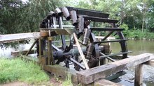

On the Regnitz, between 1250 and 1400, people began to irrigate the fields bordering the river with wooden water wheels. The operation of these wheels is documented for the first time in 1413. In 1805, around 190 such waterwheels were in operation on the Regnitz between Fürth and Forchheim over a length of approx. 25 kilometers, more than any other river in Central Europe. If you add the wheels on the Rednitz, around 250 water wheels were in use between Schwabach and Forchheim. In the meantime they have been largely replaced by modern pumping systems.
The main reasons for the heavy use of the water paddles on this section of the river were the sandy soils of the region and its hot and dry summers, both of which make heavy irrigation necessary. The even slope and the flat banks were advantageous for the use of these bikes. However, the regularly recurring spring floods , whose debris could destroy the wheels, were disadvantageous . According to the Baiersdorf Water Ordinance from 1693, which is still partly in force today, for this reason they may only be operated from May 1 to September 30.
To the north of Forchheim it was forbidden to use the water pumping wheels because the Regnitz was already navigable there and the wooden weirs (wings) running across the river that were necessary for the operation of the water pumping wheels allowed small fishing boats to pass through appropriate loopholes. The rulers of Bamberg had been interested in keeping the shipping route open as a traffic route to the royal palace in Forchheim since the 9th century. The weirs repeatedly gave rise to disputes between farmers and fishermen, for example because fishermen removed boards from the weirs to make it easier for them to pass through.
Around ten of the remaining water pumping wheels turn at Möhrendorf alone . Individual copies can be found in Fürth- Stadeln and Hausen near Forchheim. Another has been in operation since 2004 near the mouth of the Aurach near Erlangen- Bruck . Also on the Pegnitz in Nuremberg , a bike based on the historical model was put into operation again. The massive wooden structures, reminiscent of mill wheels, are nowadays set up by volunteers at the beginning of the summer season and dismantled and stored at the end of the season. Today they partly irrigate wetlands , which are supposed to maintain the food base for the numerous white storks that live in this area . A slightly scaled-down replica of such a water scoop is in the Franconian Open Air Museum in Bad Windsheim .
- Water paddle wheels in heraldry

.svg)


The wheels have had a practically unchanged structure since the 15th century. They consist almost entirely of beech and oak wood, with the exception of the iron shaft journals at both ends of the shaft, the four clamping rings of the shaft and the hoops of the Küumpfs (bucket). Each wheel is composed of around 600 individual parts. The shovel boards are attached to the bike using oak straps that are boiled for some time so that they can be bent into the desired shape. In addition, wooden nails of various lengths are also used, for example to attach the hulls to the bike. After the wheels are dismantled in autumn, up to a third of the individual parts have to be replaced in the course of the winter so that the wheels can be re-attached in spring.

How they came up with the functional principle of this machine in Middle Franconia is controversial. Water paddle wheels (norias) driven by the current were already very common in the Middle East in the early Middle Ages. This knowledge could have come to Middle Franconia through returning crusaders, pilgrims or traveling merchants. But it could also have been a regional invention. An argument against importing the technology, especially by merchants, is that further north on the Regnitz the water wheels can be detected much earlier than in the then trading metropolis of Nuremberg and its surroundings. Perhaps the construction descriptions of the Roman architect Vitruvius handed down in monasteries were also used to solve the irrigation problem. Water wheels for driving mills can already be detected in the region well before the water scoop wheels.
Each water wheel draws around 1400 cubic meters of water around four meters high per day.
Economical meaning
In the 19th century, rafts were carried out on the river from Nuremberg to Bamberg . A pumping station built in 2003 near Fürth draws water for irrigation of the Knoblauchsland .
See also
Picture gallery

... and from the north, 2008

Bridge of the A3 over the Regnitz near Eltersdorf , 2009
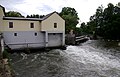
Hydropower plant Werker on the Regnitz in Erlangen , 2009

Historic fishing settlement of Little Venice on the Regnitz in Bamberg, 2009

Regnitz west of Baiersdorf, aerial photo (2015)

Buger meadows between Strullendorf and Bamberg in the evening light
Buger meadows in autumn

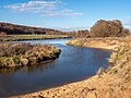
Pasture on the Regnitz between Pettstadt and Bamberg


literature
- Franz X. Bogner (2007): Rednitz and Regnitz. An aerial tour from Weißenburg to Bamberg . Verlag Fränkischer Tag, Bamberg, ISBN 978-3-936897-47-0
- Martin Eckoldt (Ed.): Rivers and canals. The history of the German waterways. DSV-Verlag Busse Seewald, Hamburg 1998, ISBN 3-88412-243-6 .
- Regina Hanemann (ed.): In the flow of history. Bamberg's lifeline Regnitz (= writings of the museums of the city of Bamberg, No. 49). Baunach 2009, therein a. a .: Thomas Gunzelmann: Bamberg as a city on the river in a Central European context , pp. 11–50 ( PDF file )
- Wolfgang Wiessner: City and District of Fürth (= Historical Place Name Book of Bavaria, Middle Franconia . Volume 1 ). Commission for Bavarian State History, Munich 1963, DNB 455524629 , p. 76 .
Individual evidence
- ↑ Flood Action Plan Main ( Memento of the original dated September 6, 2009 in the Internet Archive ) Info: The archive link was inserted automatically and has not yet been checked. Please check the original and archive link according to the instructions and then remove this notice.
- ^ Deutsches Gewässerkundliches Jahrbuch Rheingebiet, Part II 2006 Bavarian State Office for the Environment, p. 85, accessed on October 4, 2017, at: bestellen.bayern.de (PDF, German, 23.6 MB).
- ↑ Level data (MQ) from Pettstadt , increased by the area discharge of the remaining catchment area (234.78 km²), area discharge of 6.1 l / s.km² determined from level data from Kemmern , Römershofen , Pettstadt , Vorra and Schweinfurt Neuer Hafen
- ↑ Google Earth
- ↑ a b c Lengths (in km) of the main shipping routes (main routes and certain secondary routes) of the federal inland waterways ( memento of the original from January 21, 2016 in the Internet Archive ) Info: The archive link was automatically inserted and not yet checked. Please check the original and archive link according to the instructions and then remove this notice. , Federal Waterways and Shipping Administration
- ↑ a b Directory E, Ser. Nos. 32 and 45 of the Chronicle ( Memento of the original from July 22, 2016 in the Internet Archive ) Info: The archive link was automatically inserted and not yet checked. Please check the original and archive link according to the instructions and then remove this notice. , Federal Waterways and Shipping Administration
- ↑ Fishing on the Regnitz in Bamberg
- ↑ Fish stocks in the Regnitz cause concern ( Memento of the original from March 29, 2017 in the Internet Archive ) Info: The archive link was automatically inserted and not yet checked. Please check the original and archive link according to the instructions and then remove this notice.
Web links
Erlangen and the Regnitz , (PDF, 9.48 MB)