
Bischberg
| coat of arms | Germany map | |
|---|---|---|

|
Coordinates: 49 ° 55 ' N , 10 ° 50' E |
|
| Basic data | ||
| State : | Bavaria | |
| Administrative region : | Upper Franconia | |
| County : | Bamberg | |
| Height : | 236 m above sea level NHN | |
| Area : | 17.55 km 2 | |
| Residents: | 6111 (Dec. 31, 2019) | |
| Population density : | 348 inhabitants per km 2 | |
| Postal code : | 96120 | |
| Area code : | 0951 | |
| License plate : | BA | |
| Community key : | 09 4 71 117 | |
| Community structure: | 5 districts | |
| Address of the municipal administration: |
Schulstrasse 16 96120 Bischberg |
|
| Website : | ||
| Mayor : | Michael Dütsch ( Voting Community Citizens' Initiative ) | |
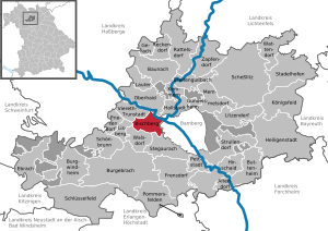
| Location of the community of Bischberg in the Bamberg district | ||
  |
||

Bischberg is a municipality in the Upper Franconian district of Bamberg about five kilometers west of Bamberg at the confluence of the Regnitz and Main rivers .
The name of the place is derived from Bischofsberg . The bishop of Würzburg is said to have ordered the town's founder to set up a base at the confluence of the Main and Regnitz rivers.
geography
The community is located in the Upper Franconia-West planning region .
Neighboring communities
The closest train stations are the train stations in Bamberg , Hallstadt and Oberhaid . Neighboring communities are (clockwise from the north): Oberhaid , Bamberg , Stegaurach , Walsdorf , Lisberg and Viereth-Trunstadt .
Parts of the community and districts
There are five districts:
- Bischberg
- Rothhof
- Trosdorf
- Tütschengereuth
- Weipelsdorf
Population numbers
The population as of January 1st, 2018:
| Part of the community | Main residence | Secondary residence | total |
|---|---|---|---|
| Bischberg | 4359 | 232 | 4591 |
| Trosdorf | 822 | 43 | 865 |
| Tütschengereuth | 693 | 11 | 704 |
| Weipelsdorf | 237 | 16 | 253 |
| Total community | 6111 | 302 | 6413 |
history


Until the church is planted
Bischberg was first mentioned in 1013 by King Heinrich II as "Biscoffesberge". The first settlement was probably built on a hill, from which the place name is derived. The place celebrated its official 1000th anniversary in 2013.
Bischenberg belonged before the secularization of the Bishopric of Bamberg , from 1500 to the Frankish Empire circle . The most important landlord was the Michelsberg Monastery , which also held local authority in the 18th century. Since the Reichsdeputationshauptschluss of 1803, the place, like large parts of Franconia, belonged to the Kingdom of Bavaria (see also History of Franconia ). In the course of the administrative reforms in Bavaria , today's municipality was created with the municipal edict of 1818 .
Incorporations
On May 1, 1978, the previously independent municipality of Trosdorf was incorporated.
Population development
In the period from 1988 to 2018, the municipality grew from 5299 to 6068 by 769 inhabitants or 14.5%.
rafting
Due to the location of Bischberg at the confluence of the Main and Regnitz rivers, the place became an important station for the raftsmen from the Franconian Forest . It was the second stop after Schwürbitz for the rafts coming from the Kronach area. Because the Regnitz strengthened the Main significantly there, the floors in Bischberg were joined to form Main rafts that were about a hundred meters long and eight meters wide. The development of traffic on road and rail made rafting extinct.
religion
According to the census on May 9, 2011, 71.5% of the population are Roman Catholic and 14.4% Evangelical Lutheran. 14.1% have another religion or are non-denominational.
politics
mayor
The professional 1st mayor has been Michael Dütsch (Bürgerinitiative) since May 1, 2020, who prevailed in a runoff election with 55.44% of the votes against Georg Schmitt (CSU). His predecessor was Johann Pfister (citizens' initiative) since 1996. This last prevailed in the 2014 election with three opposing candidates with 54.49% of the vote.
| No. | image | Name (life data) | Political party | Taking office | Term expires | Length of term of office | |
|---|---|---|---|---|---|---|---|
| 1 | Alfred Wachter
(1923-1997) |
CSU | 1978 | 1990 | 12 years | ||
| 2 | Andreas Will
(* 1950) |
CSU | 1990 | 1996 | 6 years | ||
| 3 | Johann Pfister
(1950-2020) |
BI | 1996 | 2020 | 24 years | ||
| 4th | Michael Dütsch
(* 1976) |
BI | 2020 | ||||
Municipal council
The council consists of the first mayor and the council members.
Results of the municipal council elections
Allocation of seats since 1978
| year | total | BI | CSU | FROM | SPD | Green | FW | FWG | FFB | BB | WGr |
|---|---|---|---|---|---|---|---|---|---|---|---|
| 2020 | 20th | 5 | 6th | 1 | 3 | 2 | 2 | 1 | |||
| 2014 | 20th | 6th | 5 | 3 | 2 | 2 | 1 | 1 | |||
| 2008 | 20th | 6th | 6th | 2 | 3 | 1 | 1 | 1 | |||
| 2002 | 20th | 7th | 5 | 2 | 3 | 1 | 1 | 1 | |||
| 1996 | 20th | 7th | 8th | 3 | 1 | 1 | BI | ||||
| 1990 | 20th | 5 | 7th | 6th | 2 | BI | |||||
| 1984 | 20th | 3 | 8th | 5 | 1 | 3 | |||||
| 1978 | 16 | 7th | 4th | 3 | 2 |
- AB: Active citizens
- BB: Bürgerblock, 1990 and 1996 list connection with BI
- BI: Voting Community Citizens' Initiative
- FFB: Forum for Bischberg
- FWG: Free Association of Voters
- WGr: groups of voters
coat of arms
|
|
Blazon : "In red over a silver three-mountain, two diagonally crossed, facing silver bishop's staff, covered by a golden scale." |
The Dreiberg and the two bishop's staffs stand for the two components of the word Bischberg. The bishop's staff also represent the Würzburg and Bamberg monasteries . As an attribute of the Archangel Michael, the scales symbolize the Bamberg Michelsberg Monastery, which ruled the place in the 18th century. The current coat of arms was approved by the Bavarian Ministry of the Interior in 1968.
Town twinning
A partnership with Montauban-de-Bretagne , France, has existed since August 1987 .
Educational institutions
The municipality has the following educational institutions:
- Primary School Bischberg
- Middle School Bischberg
Leisure and sports facilities
There are soccer fields in each of the municipalities and a municipal indoor swimming pool with a 25-meter pool below the Bischberg secondary school.
Culture and sights
The umbrella organization of the Bischberg clubs is the local culture ring Bischberg.
Sports and sports clubs
- The RKB Solidarity Bischberg 1925 e. V. is multiple German champion in lawn bike ball.
- The first team of the soccer club 1. FC Bischberg 1926 e. V. plays in the Bamberg 1 district class; the youth department has teams from G to A youth.
- The bowling club 1. SKK Bischberg e. V. 95 members, 40 of whom are active. The first women's team plays in the regional league Upper Franconia / Lower Franconia, the first men's team in the district league south and the youth in the district class south. Several players won the German championship for the club.
- TC Bischberg eV (5 tennis courts in the Weipelsdorf district)
- The teams of the basketball club Bischberg Baskets e. V. (U 10, U 12, U 14, U 16, women, men) play from the district class to the district league. The first men's team just missed promotion to the highest basketball league in Upper Franconia (district league) in the 2013/14 season.
Museums
The Franconian Fishing Museum is located in the village.
Buildings


The most striking building next to the church is the Lower Palace, built in 1743 by Carl Maximilian Zollner von Brand on the occasion of his marriage. Today the building houses a Greek eatery and is used as a registry office.
Regular events
The Bischberger Kirchweih takes place every year from Friday to Monday around the first Sunday in September.
Culinary specialties
Main and Regnitz fish caught and marketed by the local fishing guild.
Economy and Infrastructure
Transport links
- B 26 from Riedstadt ( Groß-Gerau ) to Bamberg
- Main valley autobahn A 70 from Schweinfurt to Bayreuth
- BA 36, local connection to Bamberg
- VGN city bus connection line 906 Bamberg (formerly: line 6) and line 995 Viereth-Trunstadt (formerly: OVF line 601) as well as line 994 Priesendorf (formerly: OVF line 641) to Bamberg and OVF line 8229 Eltmann - Knetzgau (VGN -Area: Line 952)
High speed internet
Bischberg has been supplied with fast DSL connections as far as possible since 2011. In March 2017, a contract was signed with the Bamberg city network, which provides for the supply of the industrial area of the municipality of Bischberg with fiber optic cables right into the buildings. The project is funded by the Free State of Bavaria.
Breweries
The Zur Sonne brewery in Bischberg still exists in the municipality. Until 1995 there was still the Zellmann brewery in the Tütschengereuth part of the municipality. Today she has her beer brewed at the Reckendorf Castle Brewery . The Steuer brewery was located in Trosdorf until 1968 and the Wachter brewery until 1975.
Voluntary fire brigades
Volunteer fire brigades exist in Bischberg, Trosdorf and Tütschengereuth. There is a fire fighting group in Weipelsdorf.
Sons and daughters of the church
- Philipp Kröner (1908–1964), Catholic theologian, State Caritas Director, member of the Bavarian Senate
literature
- Johann Kaspar Bundschuh : Bischberg . In: Geographical Statistical-Topographical Lexicon of Franconia . tape 1 : A-egg . Verlag der Stettinische Buchhandlung, Ulm 1799, DNB 790364298 , OCLC 833753073 , Sp. 396 ( digitized version ).
- Pleikard Joseph Stumpf : Bischberg . In: Bavaria: a geographical-statistical-historical handbook of the kingdom; for the Bavarian people . Second part. Munich 1853, p. 562 ( digitized version ).
Web links
- Bischberg community
- Bischberg: Official statistics of the LfStat (PDF; 1.24 MB)
Individual evidence
- ↑ "Data 2" sheet, Statistical Report A1200C 202041 Population of the municipalities, districts and administrative districts 1st quarter 2020 (population based on the 2011 census) ( help ).
- ↑ a b Mayor / Lord Mayor in municipalities belonging to the district (as of May 1st, 2020). (xlsx) Bavarian State Office for Statistics, accessed on May 31, 2020 .
- ↑ http://www.bayerische-landesbibliothek-online.de/orte/ortssuche_action.html ? Anzeige=voll&modus=automat&tempus=+20111101/182128&attr=OBJ&val= 1107
- ↑ Population figures on the homepage of the municipality of Bischberg
- ^ Bavarian State Office for Statistics: Genesis online
- ^ Homepage of the Bischberg community
- ↑ Johannes Neumann: The Reichsdeputationshauptschluss of 1803: Requirements and consequences (PDF file; 179 kB)
- ^ Federal Statistical Office (ed.): Historical municipality directory for the Federal Republic of Germany. Name, border and key number changes in municipalities, counties and administrative districts from May 27, 1970 to December 31, 1982 . W. Kohlhammer GmbH, Stuttgart / Mainz 1983, ISBN 3-17-003263-1 , p. 673 .
- ↑ Document of the Flößergemeinschaft Wallenfels ( Memento of the original from July 18, 2016 in the Internet Archive ) Info: The archive link was automatically inserted and not yet checked. Please check the original and archive link according to the instructions and then remove this notice. (PDF file; 190kB)
- ^ Entry on the coat of arms of Bischberg in the database of the House of Bavarian History
- ^ Website of the Bischberg community
- ↑ Business park on the net. In: infranken.de. Mediengruppe Oberfranken, March 20, 2017, accessed on March 31, 2017 .

Altendorf | Baunach | Bischberg | Breitengüßbach | Burgebrach | Burgwindheim | Buttenheim | Ebrach | Frensdorf | Gerach | Gundelsheim | Hallstadt | Heiligenstadt in Upper Franconia | Hirschaid | Kemmern | Koenigsfeld | Louder | Lisberg | Litzendorf | Memmelsdorf | Oberhaid | Pettstadt | Pommersfelden | Priesendorf | Rattelsdorf | Reckendorf | Scheßlitz | Key field | Schönbrunn im Steigerwald | Stadelhofen | Stegaurach | Strullendorf | Viereth-Trunstadt | Walsdorf | Wattendorf | Zapfendorf
Community-free areas
Ebracher Forst |
Eichwald |
Geisberger Forest |
Main Bog Forest |
Koppenwinder Forest |
Lindach |
Semberg |
Steinachsrangen |
Winkelhofer Forest |
Zückshuter Forest