
Gross-Gerau
| coat of arms | Germany map | |
|---|---|---|

|
Coordinates: 49 ° 55 ' N , 8 ° 29' E |
|
| Basic data | ||
| State : | Hesse | |
| Administrative region : | Darmstadt | |
| Circle : | Gross-Gerau | |
| Height : | 89 m above sea level NHN | |
| Area : | 54.48 km 2 | |
| Residents: | 25,559 (Dec. 31, 2019) | |
| Population density : | 469 inhabitants per km 2 | |
| Postcodes : | 64501-64521 | |
| Area code : | 06152 | |
| License plate : | GG | |
| Community key : | 06 4 33 006 | |
| LOCODE : | DE GRG | |
| City structure: | 6 districts | |
City administration address : |
Am Marktplatz 1 64521 Groß-Gerau |
|
| Website : | ||
| Mayor : | Erhard Walther ( CDU ) | |
| Location of the city of Groß-Gerau in the Groß-Gerau district | ||
  |
||

Groß-Gerau is the district town of the Groß-Gerau district in southern Hesse . It is located in the southern Rhine-Main area and takes on the function of a medium-sized center compared to the surrounding area .
geography
Geographical location
Groß-Gerau is located in the north of the Hessian Ried in the Upper Rhine Plain , not far from the Rhine and Main . A few kilometers to the southwest lies the largest Hessian nature reserve, the Kühkopf-Knoblochsaue, with the Swedish column .
Neighboring communities
Groß-Gerau borders in the north on the municipality of Nauheim , in the northeast on the city of Mörfelden-Walldorf , in the east on the municipality of Büttelborn (whose district Klein -Gerau explains the name of the town of Groß-Gerau), in the southeast on the city of Griesheim ( district Darmstadt-Dieburg ), in the south to the city of Riedstadt , and in the west to the municipality of Trebur .
City structure
Groß-Gerau is divided into the core city and four other districts, which are listed below with the number of inhabitants (as of June 30, 2017):
| district | population |
|---|---|
| Groß-Gerau, core city | 16606 |
| Berkach | 1128 |
| Dornberg | 410 |
| Dornheim | 4644 |
| Waller cities | 2708 |
| total | 25496 |
Since local districts have not been established in Groß-Gerau , these districts only have the rank of districts and statistical districts .
In the north of the district town of Groß-Gerau there is also the settlement north , south of the core town Groß-Gerau the settlement Auf Esch and in the south of the district town Groß-Gerau the settlement Am Schwarzen Berg , which is assigned to the Dornheim district. These settlements are perceived as separate city districts.
history
Overview


Even in Roman times, today's urban area was of greater importance. The Groß-Gerau fort in the area of the “Auf Esch” / Fasanerie district secured the bridgehead of the Roman provincial capital Mainz, even before the Limes was built and what is now southern Hesse became Roman. The route of the B 44 from the southern tip of the Fasanerie to Dornheim is identical to the Roman road from Mainz via Groß-Gerau to Ladenburg ; she ran towards the south gate of the fort. With the establishment of the Civitas Auderiensium , the fort was abandoned and the vicus camp remained as a market place. The proximity of this vicus to the later mentioned medieval moated castle Dornberg will not be a coincidence.
The Gerauer Mark (the forest area between Wallerstädten and Messel) was first mentioned in a document in 910 in a deed of donation from Archbishop Hatto I of Mainz . Subsequently, the lords of Dornberg ruled the region, who may have been servants of the Hohenstaufen emperors in the Frankfurt Palatinate (1160 mention of the moated castle in the area of today's Dornberg, later Dornberg Castle ). After the lords of Dornberg died out, the Counts of Katzenelnbogen , who came from the Westerwald and Middle Rhine region, succeeded them and in 1398 obtained city rights for Groß-Gerau. In 1479, Count Philipp I the Elder of Katzenelnbogen died without a male successor and the county fell to the Landgraviate of Hesse .
In 1557 there were only three “well-established schools maintained from church funds” in the 35 parishes of the Upper County, namely in Darmstadt , Groß-Gerau and Zwingenberg . Before Landgrave Philipp von Hessen died in 1567, another was added in Auerbach. This makes Groß-Gerau one of the oldest school locations in Hessen. In 1578 the construction of the town hall began. This is where the jury and the landgrave appointed mayors met. The Rathaus-Apotheke has existed since 1701 and is the oldest pharmacy in the Upper County outside of Darmstadt.
The Groß-Gerau city church was set on fire in 1634 by imperial troops during the Thirty Years' War . Landgrave Ludwig VI. von Hessen-Darmstadt renewed the town charter in 1663 against a payment of 24,000 guilders. These rights included the elimination of compulsory labor, the collection of market stall fees, representation in the state parliament and the right to drive Jews out of the city. Administratively, Groß-Gerau in Hesse was part of the " Rüsselsheim Office " until 1821 . Due to the administrative reform of 1821 in the Grand Duchy of Hesse, the place was assigned to the Dornberg district of the Starkenburg province .
The statistical-topographical-historical description of the Grand Duchy of Hesse reports on Groß-Gerau in 1829:
“Großgerau ( L. Bez. Dornberg ) city; lies on the Schwarzbach, on the Chaussee that runs from Darmstadt to Oppenheim, 3 hours from Darmstadt, 3 hours from Oppenheim, 4 hours from Mainz, 6 hours from Frankfurt and 1 ⁄ 4 hours from Dornberg; is surrounded by a moat filled with water, has wide, friendly streets and a few covered gates. There are 235 houses and 1,719 inhabitants, the, 13 Cath., 1 Reform. And 45 Jews excepted, all of whom are Lutheran, and among these 118 farmers, 254 artisans and 67 day laborers. The city is the seat of the regional court, the rent office and the tax commissioner. Großgerau has a large old church in which a count. Katzenellenbogensche line is buried, and its high tower is visible from afar because of its white paint. also 2 parsonages and 2 school houses, a synagogue, 1 Jewish burial place and a post office. There are 5 shopkeepers and 2 cattle markets every year. The hospital for the poor has a not insignificant fortune. There are peat graves in the area. - Großgerau already appears as an imperial village in the times of Emperor Heinrich II. This emperor gave the Curtis Gerau, at that time part of the county of Adelbert, to Würzburg in 1013. The Würzburg property was lost, however, and the Curtis came to a line of the Counts of Henneberg in the Upper Rhinegau, who enfeoffed the Lords of Dornberg with it in the 12th century. After the departure of the Lords of Dornberg, in 1259, Großgerau came to the Counts of Katzenellenbogen, who introduced the place into the Würzburg fiefdoms. Würzburg enfeoffed these counts too, until the Counts of Henneberg reasserted their rights, but renounced it in 1521 against Landgrave Philip the Magnanimous. Großgerau mainly came up under the Counts of Katzenellenbogen, and it was before the castle in Darmstadt was built. to a certain extent the capital of the Upper County of Katzenellenbogen. No less did the many parish places and the close residence of the Counts of Katzenellenbogen in Dornberg Castle, which contributed a lot to the Flor. In 1398, Großgerau received town and market rights from King Wenceslaus. The church used to have 9 altars and the places Dornberg, Kleingerau, Worfelden, Berkach, Wallerstädten, Büttelborn, Wixhausen. Graefenhausen. Weiterstadt and Braunshardt become branches, which are now separated except for the first four. Großgerau was also the seat of superintendents several times. In the Thirty Years' War the place was so badly damaged that no more than 50 residents and 39 houses remained. The church was also burned down in 1634, and in April and May 1647 the city was the headquarters of Marshal Türenne. "
1832 Province Starkenburg is then in circles divided and Gross-Gerau for Gross-Gerau district , initially based in Dornberg. It belongs to this group until today, only interrupted by the division of Starkenburg into administrative districts. From 1848 to 1852 it was part of the Darmstadt administrative region . In the course of the reform of the district constitution in the Grand Duchy of Hesse based on the Prussian model in 1874, there was also a new district division. Due to this reform, Groß-Gerau becomes the district town of the Groß-Gerau district, which has remained almost unchanged to this day.
The competent jurisdiction was during the affiliation to Hesse, from 1821 to 1879 the district court Großgerau and from 1879 the district court Groß-Gerau .
In the 19th century, Groß-Gerau became the district town of the Groß-Gerau district in the Starkenburg province in the Grand Duchy of Hesse, and industrialization began here too . Due to the connection to the Hessische Ludwigsbahn with the lines Darmstadt - Mainz 1858 and Frankfurt am Main - Mannheim 1879 ( Riedbahn ) a diverse commercial life could develop. The city became the seat of metal processing (FAGRO), canning factories (Helvetia), cheese factories ( Mainz cheese is produced in GG ) and the sugar industry. From 1869 to 1871, Groß-Gerau was the epicenter of a series of around 2000, mostly weak, earthquakes. In 1896 the construction of a steam tram from Darmstadt via Groß-Gerau to Oppenheim was discussed, but not realized.
In June 1994, Groß-Gerau was the “secret capital” of Hesse as the venue for the Hessentag for ten days.
In the present, the overall economic situation in the city of Groß-Gerau and especially in the district of Groß-Gerau has deteriorated. A relatively high level of indebtedness and the strict control of public budgets (especially the district) by the Darmstadt Regional Council are evidence of this.
Incorporations
On April 1, 1939, Dornberg was incorporated into the city of Groß-Gerau. As part of the regional reform in Hesse , the community of Berkach voluntarily incorporated itself into Groß-Gerau on December 31, 1971. Finally, the city Gross-Gerau and the communities were on 1 January 1977. virtue of state law Dornheim and Wallerstädten the new city Gross-Gerau together . Local districts according to the Hessian municipal code were not established.
Historical forms of names
In historical documents, the place is documented under the following place names (the year of mention in brackets):
| Geraha marca (910) | Geraha (1002/09/13) | Straight (1257) |
| Gerhahe (1277) | Gera (1311) | major et minor villa Gera (1319) |
| Gera, major et minor villa (1319) | Groizen Gera (1341) | Maius Gera (1355) |
| Gerau (1368) | Gerauwe (1368) | Grozen Geraw (1371) |
| Girrauwer (around 1375) | Gerau parvum et magnum (1403) | Geraw (1420) |
| Great Gerauwe (1460) | Great Geraw (1613) |
Territorial history and administration
The following list gives an overview of the territories in which Groß-Gerau was located and the administrative units to which it was subordinate:
- before 1479: Holy Roman Empire , County Katzenelnbogen , Upper County Katzenelnbogen , Amt Dornberg
- from 1479: Holy Roman Empire, Landgraviate of Hesse , Upper County of Katzenelnbogen, Office of Rüsselsheim
- from 1567: Holy Roman Empire, Landgraviate Hessen-Darmstadt , Upper County, Rüsselsheim Office
- from 1803: Holy Roman Empire, Landgraviate Hessen-Darmstadt, Principality of Starkenburg , Rüsselsheim Office
- from 1806: Grand Duchy of Hesse , Principality of Starkenburg, Rüsselsheim Office
- from 1815: German Confederation , Grand Duchy of Hesse, Province of Starkenburg , Rüsselsheim Office
- from 1821: German Confederation, Grand Duchy of Hesse, Starkenburg Province, Dornberg District District (separation between justice ( Groß-Gerau District Court ) and administration)
- from 1832: German Confederation, Grand Duchy of Hesse, Province of Starkenburg, District of Groß-Gerau
- from 1848: German Confederation, Grand Duchy of Hesse, Darmstadt administrative district
- from 1852: German Confederation, Grand Duchy of Hesse, Province of Starkenburg, District of Groß-Gerau
- from 1866: Grand Duchy of Hesse, Starkenburg Province, Groß-Gerau district
- from 1871: German Empire , Grand Duchy of Hesse, Starkenburg Province, Groß-Gerau district
- from 1918: German Empire, People's State of Hesse , Starkenburg Province, Groß-Gerau district
- from 1938: German Reich, People's State of Hesse, Groß-Gerau district (In the course of the regional reform in 1938 , the three Hessian provinces of Starkenburg, Rheinhessen and Upper Hesse were dissolved.)
- from 1945: American occupation zone , Greater Hesse , Darmstadt administrative district, Gross-Gerau district
- from 1949: Federal Republic of Germany , State of Hesse , Darmstadt district, Groß-Gerau district
population
Population structure
According to the 2011 census , there were 23,739 residents in Groß-Gerau on May 9, 2011. These included 3821 (16.1%) foreigners of whom 1638 came from outside the EU , 1421 from other European countries and 762 from other countries. 15.9% of the German residents had a migration background . The inhabitants lived in 10,160 households. Of these, 3276 were single households , 2898 couples with children and 2966 couples without children, as well as 771 single parents and 249 shared apartments .
Population development
Source: Historical local dictionary
| • 1600: | 171 hearths |
| • 1629: | 170 house seats |
| • 1636: | 10 inhabitants |
| • 1791: | 1360 inhabitants |
| • 1800: | 1458 inhabitants |
| • 1806: | 1545 inhabitants, 236 houses |
| • 1829: | 1719 inhabitants, 235 houses |
| • 1867: | 2542 inhabitants, 346 houses |
| Groß-Gerau: Population from 1791 to 2015 | ||||
|---|---|---|---|---|
| year | Residents | |||
| 1791 | 1,360 | |||
| 1800 | 1,458 | |||
| 1806 | 1,545 | |||
| 1829 | 1,719 | |||
| 1834 | 2,065 | |||
| 1840 | 2,216 | |||
| 1846 | 2,344 | |||
| 1852 | 2,371 | |||
| 1858 | 2,541 | |||
| 1864 | 2,702 | |||
| 1871 | 2,697 | |||
| 1875 | 2,932 | |||
| 1885 | 3,552 | |||
| 1895 | 4,203 | |||
| 1905 | 5,284 | |||
| 1910 | 5,837 | |||
| 1925 | 6.267 | |||
| 1939 | 7.150 | |||
| 1946 | 8,276 | |||
| 1950 | 9,252 | |||
| 1956 | 10,606 | |||
| 1961 | 12,202 | |||
| 1967 | 13,184 | |||
| 1970 | 13,077 | |||
| 1972 | 14,255 | |||
| 1976 | 19,958 | |||
| 1984 | 21,513 | |||
| 1992 | 22,575 | |||
| 2005 | 23,538 | |||
| 2010 | 23,431 | |||
| 2011 | 23,739 | |||
| 2015 | 24,354 | |||
| Data source: Historical municipality register for Hesse: The population of the municipalities from 1834 to 1967. Wiesbaden: Hessisches Statistisches Landesamt, 1968. Further sources: up to 1970 :; 1972 :; 1976 :; 1984 :; 1992 :; 2000 :; 2005 :; 2010 :; 2011 census; 2015: From 1972 onwards, the figures contain the incorporated towns after the regional reform in Hesse . | ||||
Religious affiliation
Source: Historical local dictionary
| • 1829: | 1660 Lutheran (= 96.57%), 1 Reformed (= 0.06%), 45 Jewish (= 2.62%) and 13 Catholic (= 0.76%) residents |
| • 1961: | 8301 Protestant (= 68.04%) and 3227 Catholic (= 26.45%) residents |
| • 2011: | 8420 Protestant (= 35.5%), 5330 Catholic (= 22.5%), 510 Orthodox (= 2.2%), 970 non-believers (= 4.1%), 8350 other (= 35.2%) residents |
Gainful employment
The municipality in comparison with the district, administrative district Darmstadt and Hesse:
| year | local community | district | Administrative district | Hesse | |
|---|---|---|---|---|---|
| Employees subject to social security contributions | 2017 | 11,027 | 98,042 | 1,695,567 | 2,524,156 |
| Change to | 2000 | + 17.3% | + 5.4% | + 16.1% | + 16.0% |
| of which full-time | 2017 | 69.8% | 75.9% | 72.8% | 71.8% |
| of which part-time | 2017 | 30.2% | 24.1% | 27.2% | 28.2% |
| Only marginally paid employees | 2017 | 1,518 | 13,048 | 224.267 | 372.991 |
| Change to | 2000 | + 20.4% | −9.6% | + 9.0% | + 8.8% |
| Branch | year | local community | district | Administrative district | Hesse |
|---|---|---|---|---|---|
| Manufacturing | 2000 | 29.1% | 43.8% | 27.0% | 30.6% |
| 2017 | 21.6% | 33.2% | 20.4% | 24.3% | |
| Commerce, hospitality and transport | 2000 | 27.4% | 27.6% | 26.4% | 25.1% |
| 2017 | 25.4% | 27.9% | 24.7% | 23.8% | |
| Business services | 2000 | 14.5% | 14.0% | 25.1% | 20.2% |
| 2017 | 16.9% | 19.9% | 31.6% | 26.1% | |
| other services | 2000 | 28.4% | 13.7% | 20.1% | 22.5% |
| 2017 | 35.8% | 18.6% | 23.0% | 25.4% | |
| Other (or without assignment) | 2000 | 0.6% | 1.0% | 1.4% | 1.5% |
| 2017 | 0.3% | 0.5% | 0.3% | 0.4% |
religion

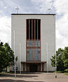
The Protestant town church
The Catholic
St. Walburga Church
The
Bait ul-Shakur mosque


Evangelical community
Groß-Gerau has four Protestant parishes. In the city center the town parish and the parish Groß-Gerau Süd as well as in the districts of Dornheim and Wallerstädten.
Catholic community
The Catholic religious community has its community center in the St. Walburga Church on Walburgastraße. The parish Wallerstädten is assigned.
Muslim communities
The Turkish-Islamic Congregation was founded on October 14, 1986 at Fabrikstrasse 2. The Turkish-Islamic Community is legally and economically an independently registered association, which pursues the same principles and statutory purposes of the DITIB and recognizes the DITIB as an umbrella organization.
The house of prayer of the Muslim community of the IGMG is located on Sudetenstrasse.
The Muslim Center, the house of prayer of an association associated with the Turkish VIKZ , is located in Friedhofstrasse.
The religious community Ahmadiyya Muslim Jamaat bought the former area “Märchenland” in the north of the city in 1985 and now calls it “ Nasir Bagh ”. It is located at the end of the village on the B 44 in the direction of Mörfelden . The annual meetings ( Jalsa Salana ) took place there until 1994 . Since the space could no longer offer sufficient capacity, they took place from 1995 to 2010 on the Mannheim Maimarkt area . The Jalsa Salana Germany has been held annually at Messe Karlsruhe since 2011 . Today the " Nasir Bagh " area is only used for regional events.
In 1992 the mosque " Bait ul-Shakur " ("House of the Worthy") was built on the site . It offers space for around 850 people on two floors and, with a prayer area of 600 m², is the largest mosque of the Ahmadiyya Muslim Community in Germany. The mosque also has a dome-high minaret, which is modeled on the White Minaret of Qadian .
politics
City Council
The local elections on March 6, 2016 produced the following results, compared to previous local elections:
| Parties and constituencies |
% 2016 |
Seats 2016 |
% 2011 |
Seats 2011 |
% 2006 |
Seats 2006 |
% 2001 |
Seats 2001 |
||
| CDU | Christian Democratic Union of Germany | 31.1 | 10 | 33.9 | 11 | 25.0 | 8th | 24.5 | 8th | |
| SPD | Social Democratic Party of Germany | 31.2 | 10 | 32.2 | 11 | 29.5 | 10 | 41.0 | 14th | |
| GREEN | Alliance 90 / The Greens | 11.1 | 4th | 19.7 | 7th | 9.6 | 3 | 12.7 | 4th | |
| COMBINATION | Local community interest group | 9.4 | 3 | 9.5 | 3 | 31.7 | 11 | 21.7 | 7th | |
| Die Linke.OL | The Left. Open List | 5.4 | 2 | 3.8 | 1 | 4.2 | 1 | - | - | |
| FDP | Free Democratic Party | 4.6 | 2 | 1.0 | 0 | - | - | - | - | |
| FW citizen list | Free Voter Citizen List | 7.3 | 2 | - | - | - | - | - | - | |
| total | 100.0 | 33 | 100.0 | 33 | 100.0 | 33 | 100.0 | 33 | ||
| Voter turnout in% | 43.5 | 44.7 | 47.9 | 50.9 | ||||||


mayor
According to the Hessian municipal constitution, the mayor is elected directly every six years and is chairman of the magistrate , which in the city of Groß-Gerau includes six voluntary councilors in addition to the mayor . Stefan Sauer (CDU) had been mayor since 2007 - until the 2017 federal election and his appointment to the German Bundestag. He then resigned from the mayor's office on October 12, 2017. His directly elected predecessors were
- 2001 to 2007 Karl Helmut Kinkel (KOMBI)
- 1983 to 2001 Manfred Hohl (SPD)
In the election of Stefan Sauer's successor to the mayor's office on January 21, 2018, none of the candidates achieved an absolute majority. In the runoff election on February 4, 2018, Erhard Walther (CDU) was elected as the new mayor.
coat of arms
The town of Groß-Gerau in the district of Groß-Gerau was granted a coat of arms with the following blazon by the Hessian Ministry of the Interior and for Agriculture, Forests and Nature Conservation on January 22, 1996 , which was used until the town of Groß-Gerau was merged with the communities of Dornheim and Wallerstädten was led by the former town of Groß-Gerau: In a split shield above in blue the growing Hessian lion , below in gold a floating red equal-armed cross, angularly angled by two green onions and two green heads of cabbage. Above the sign is a tinned city wall with a round gate and three tinned round towers.
Town twinning
Groß-Gerau is in a ring partnership with the cities of Brignoles (Provence, France, since 1959), Bruneck (South Tyrol, Italy, since 1959), Tielt (West Flanders, Belgium, since 1959) and Szamotuły (Greater Poland Voivodeship, Poland, since 2000) connected.
Sights and culture
Buildings
In the center, especially in Mainzer Straße , Schulstraße and its extension Am Sandböhl and the front part of Frankfurter Straße , Groß-Gerau has a number of lovingly restored half-timbered houses . On the area of the Fasanerie Groß-Gerau , a large park in the style of an English landscape garden , there is also a privately run zoo .

Half-timbered house in Schulstrasse

Half-timbered houses Am Sandböhl

Half-timbered house in Schulstrasse

Executioner's House in Mainzer Strasse

Half-timbered house in Mainzer Strasse

Half-timbered house in Mainzer Strasse

At the market square


Museums
The Groß-Gerau City Museum has existed since 1929.
Economy and Infrastructure
Land use
The municipality covers a total area of 5448 hectares, of which in hectares are:
| Type of use | 2011 | 2015 | |
|---|---|---|---|
| Building and open space | 594 | 605 | |
| from that | Living | 300 | 299 |
| Business | 82 | 83 | |
| Operating area | 59 | 49 | |
| from that | Mining land | 0 | 0 |
| Recreation area | 80 | 79 | |
| from that | Green area | 56 | 56 |
| traffic area | 374 | 375 | |
| Agricultural area | 2878 | 2875 | |
| from that | moor | 0 | 0 |
| pagan | 0 | 0 | |
| Forest area | 1346 | 1345 | |
| Water surface | 92 | 92 | |
| Other use | 26th | 26th | |
education
|
|
traffic


The B 42 / L 3482 and B 44 cross in Groß-Gerau . The north and south motorway junctions create connections in all directions via the A 67 . The surrounding large cities are also close by ( Darmstadt 11 km, Wiesbaden 23 km, Mainz 18 km and Frankfurt am Main 28 km). The Frankfurt Airport can be reached by motorway in about 15 minutes.
In addition, Groß-Gerau is connected to two railway lines that intersect at approximately right angles on the eastern outskirts. There are the Rhein-Main-Bahn Mainz - Darmstadt - Aschaffenburg and the Riedbahn Mannheim - Frankfurt . Both lines are double-track and electrified. There are three train stations in the city:
- Station Gross Gerau , just north of the Rhine-Main Railway of the city center
- Groß Gerau-Dornberg station on the Riedbahn, set off a little to the south-east of the city center in an industrial area
- Groß Gerau-Dornheim stop , also on the Riedbahn, about four kilometers further south in the village of the same name.
There are two connecting curves between the railway lines on the Mannheim-Mainz and Mannheim-Darmstadt routes. Both play a role primarily in freight transport. There is no passenger traffic between the train stations Groß Gerau and Groß Gerau-Dornberg. The "misspelling" of the station names without a hyphen is based on the different spelling rules of the Grand Duchy of Hesse and the Kingdom of Prussia. The Royal Prussian and Grand Ducal Hessian State Railways (KPuGHStE) named the stations according to the Prussian spelling rules.
Established businesses
The following well-known companies are located in the city:
- Procter & Gamble , Groß-Gerau plant (formerly Wick ; oral care and pharmaceuticals)
- Frigoropa GmbH (EK19), subsidiary of Nordfrost GmbH & Co. KG, Schortens (cold store / logistics)
- Erlenbacher Backwaren GmbH , subsidiary of Nestlé AG
Several traditional companies, such as Fagro or the Südzucker AG plant , were closed.
media
The daily newspapers are the "Groß-Gerauer Echo" (formerly "Heimatzeitung"), which belongs to the newspaper family of the VRM publishing group , as well as Frankfurt newspapers with regional pages , also for Groß-Gerau. In addition, the local monthly magazine “Wir” appears. The "Christian Gallus Verlag", publisher of the nationwide Geocaching magazine , is also based in Groß-Gerau .
Power grid and supply
The power grid is operated by the Groß-Gerau municipal utility . These also act as local energy suppliers. They are majority owned by the city of Groß-Gerau.
Personalities
sons and daughters of the town
- Franz Staudinger (1849–1921), high school professor, philosopher and teacher in the consumer cooperative movement
- Ludwig Münch (1852–1922), teacher and member of the state parliament
- Wilhelm Diehl (1871–1944), theologian, church historian and member of the state parliament ( DNVP )
- Heinrich Walther (1866–1950), gynecologist
- Adam Herbert (1887–1976), pharmacist, entrepreneur and patron
- Karl Spreng (1904–1982), lawyer, judge at the Federal Court of Justice from 1956 to 1972
- Martin Schlappner (1931–2008), politician ( SPD )
- Herbert Friedmann (1951-2019), author
- Lothar Skala (1952–2008), former Bundesliga soccer player from the Groß-Gerau district of Dornheim
- Carina Gödecke (* 1958), politician (SPD)
- Dieter Georg Adlmaier-Herbst (* 1960), communication scientist
- Ralf Schwob (* 1966), writer
- Dirk Hamm (* 1968), film producer
- Silke Heimes (* 1968), author
- Oliver Leicht (* 1969), jazz saxophonist
- Tobias Reinhardt (* 1971), classical philologist
- Thorsten Schmid (* 1971), handball trainer
- Heike Hofmann (* 1973), politician (SPD)
- Maike Wetzel (* 1974), writer and screenwriter
- Antje Dammel (* 1976), linguist
- Dominik Burkhardt (* 1977), track and field athlete
- Nadine Hahl (* 1978), actress
- Indira Weis (* 1979), pop singer
- Fabio De Masi (* 1980), German-Italian economist and politician ( Die Linke )
- Daniel Zschätzsch (* 1982), speed skater and speed skater
- Christina Dietrich (* 1984), television presenter and journalist
- Kevin Klier (* 1984), handball player
- Sascha Herröder (* 1988), soccer player
- Andreas Heinz (* 1991), badminton player
- Faisal Kawusi (* 1991), comedian
- Fabian Dudek (* 1995), jazz musician
Personalities who work or worked in Groß-Gerau
- Johannes Angelus (1542–1608), Lutheran theologian and pastor
- Wilhelm Hammann (1897–1955), member of the state parliament and local politician ( KPD )
- Walter Buss (1920–2017), presiding judge at the Federal Social Court a. D.
- Georg Sturmowski (1923-2017), politician ( CDU )
- Ralf Raps (* 1960), former Bundesliga soccer player from the Groß-Gerau district of Dornheim
literature
- Literature on Groß-Gerau in the Hessian Bibliography
- Literature by and about Groß-Gerau in the catalog of the German National Library
Web links
- Website of the city of Groß-Gerau
- Groß-Gerau In: Website of the district of Groß-Gerau
- Groß-Gerau, district of Groß-Gerau. Historical local dictionary for Hessen. In: Landesgeschichtliches Informationssystem Hessen (LAGIS).
- Information on the community of Groß-Gerau. In: Hessisches Gemeindelexikon. HA Hessen Agentur GmbH , 2016.
- Link catalog on the subject of Groß-Gerau at curlie.org (formerly DMOZ )
Individual evidence
- ↑ Hessian State Statistical Office: Population status on December 31, 2019 (districts and urban districts as well as municipalities, population figures based on the 2011 census) ( help ).
- ↑ Population figures in the city portrait
- ↑ Official mention of the Auf Esch district (day care center)
- ↑ Headlines from Bensheim on the 175th anniversary of the "Bergsträßer Anzeiger" 2007. (PDF 8.61 MB) A school location with tradition. (No longer available online.) P. 70 , archived from the original on October 5, 2016 ; accessed on December 28, 2014 .
- ^ A b c Georg Wilhelm Justin Wagner : Statistical-topographical-historical description of the Grand Duchy of Hesse: Province of Starkenburg . tape 1 . Carl Wilhelm Leske, Darmstadt October 1829, OCLC 312528080 , p. 89 f . ( Online at google books ).
- ↑ a b c d e f g Groß-Gerau, Groß-Gerau district. Historical local lexicon for Hessen (as of March 23, 2018). In: Landesgeschichtliches Informationssystem Hessen (LAGIS). Hessian State Office for Historical Cultural Studies (HLGL), accessed on June 4, 2018 .
- ^ Franz flat: Gerauer stories. 600 years of city and market rights. Groß-Gerau 1997, p. 58 f.
- ^ Municipal reform in Hesse: amalgamation and structure of municipalities of December 29, 1971 . In: The Hessian Minister of the Interior (ed.): State Gazette for the State of Hesse. 1972 No. 3 , p. 84, 87 , point 93, no. 60 ( online at the information system of the Hessian state parliament [PDF; 6.0 MB ]).
- ↑ Gerstenmeier, K.-H. (1977): Hessen. Municipalities and counties after the regional reform. A documentation. Melsungen. P. 253. DNB 770396321
- ↑ Law on the reorganization of the district of Groß-Gerau (GVBl. II 314–32) of July 26, 1974 . In: The Hessian Minister of the Interior (ed.): Law and Ordinance Gazette for the State of Hesse . 1974 No. 22 , p. 314 , § 3 ( online at the information system of the Hessian state parliament [PDF; 1.5 MB ]).
- ^ Michael Rademacher: German administrative history from the unification of the empire in 1871 to the reunification in 1990. State of Hesse. (Online material for the dissertation, Osnabrück 2006).
- ^ Grand Ducal Central Office for State Statistics (ed.): Contributions to the statistics of the Grand Duchy of Hesse . tape 1 . Darmstadt 1866, p. 43 ff . ( online at Google Books ).
- ↑ Population according to nationality groups: Groß-Gerau, Stadt. In: Zensus2011. Bavarian State Office for Statistics , accessed in May 2015 .
- ↑ Migration background in%: Groß-Gerau, city. In: Zensus2011. Bavarian State Office for Statistics , accessed in May 2015 .
- ^ Households by family: Groß-Gerau, Stadt. In: Zensus2011. Bavarian State Office for Statistics , accessed in May 2015 .
- ↑ Hessen-Darmstadt state and address calendar 1791 . In the publishing house of the Invaliden-Anstalt, Darmstadt 1791, p. 123 ( online in the HathiTrust digital library ).
- ↑ Hessen-Darmstadt state and address calendar 1800 . In the publishing house of the Invaliden-Anstalt, Darmstadt 1800, p. 129 ( online in the HathiTrust digital library ).
- ↑ List of offices, places, houses, population. (1806) HStAD inventory E 8 A No. 352/4. In: Archive Information System Hessen (Arcinsys Hessen), as of February 6, 1806.
- ^ Ph. AF Walther : Alphabetical index of the residential places in the Grand Duchy of Hesse . G. Jonghaus, Darmstadt 1869, OCLC 162355422 , p. 32 ( online at google books ).
- ^ Local elections 1972; Relevant population of the municipalities on August 4, 1972 . In: The Hessian Minister of the Interior (ed.): State Gazette for the State of Hesse. 1972 No. 33 , p. 1424 , point 1025 ( online at the information system of the Hessian state parliament [PDF; 5.9 MB ]).
- ↑ Local elections 1977; Relevant population figures for the municipalities as of December 15, 1976 . In: The Hessian Minister of the Interior (ed.): State Gazette for the State of Hesse. 1976 No. 52 , p. 2283 , point 1668 ( online at the information system of the Hessian state parliament [PDF; 10.3 MB ]).
- ^ Local elections 1985; Relevant population of the municipalities as of October 30, 1984 . In: The Hessian Minister of the Interior (ed.): State Gazette for the State of Hesse. 1984 No. 46 , p. 2175 , point 1104 ( online at the information system of the Hessian state parliament [PDF; 5.5 MB ]).
- ↑ local elections 1993; Relevant population of the municipalities as of October 21, 1992 . In: The Hessian Minister of the Interior (ed.): State Gazette for the State of Hesse. 1992 No. 44 , p. 2766 , point 935 ( online at the information system of the Hessian state parliament [PDF; 6.1 MB ]).
- ↑ a b municipality data sheet : Groß-Gerau. (PDF; 222 kB) In: Hessisches Gemeindelexikon. HA Hessen Agency GmbH
- ^ The population of the Hessian communities (June 30, 2005). (No longer available online.) In: Hessisches Statistisches Landesamt . Archived from the original .
- ^ The population of the Hessian communities (June 30, 2010). (No longer available online.) In: Hessisches Statistisches Landesamt . Archived from the original .
- ↑ Population figures : Groß-Gerau, city. In: Zensus2011. Bavarian State Office for Statistics , accessed in May 2015 .
- ^ The population of the Hessian communities (June 30, 2015). (No longer available online.) In: Hessisches Statistisches Landesamt . Archived from the original .
- ↑ Religious affiliation : Groß-Gerau, Stadt. In: Zensus2011. Bavarian State Office for Statistics , accessed in May 2015 .
- ^ Result of the municipal election on March 6, 2016. 433006 Groß-Gerau, Stadt. Hessian State Statistical Office, accessed in April 2016 .
- ^ Result of the municipal election of March 27, 2011. 433006 Groß-Gerau, Stadt. Hessian State Statistical Office, accessed in October 2019 .
- ^ Result of the municipal elections of March 26, 2006. 433006 Groß-Gerau, St. Hessian State Statistical Office, accessed in October 2019 .
- ^ Hessian State Statistical Office: direct elections in Groß-Gerau
- ^ Groß-Gerau: Mayor Stefan Sauer , accessed on August 6, 2016.
- ↑ Mayoral election in Groß-Gerau, Stadt (runoff election). Hessian State Statistical Office
- ^ Approval of a coat of arms and a flag for the city of Groß-Gerau from January 22, 1996 . In: The Hessian Minister of the Interior (ed.): State Gazette for the State of Hesse. 1996 No. 6 , p. 520 , point 158 ( online at the information system of the Hessian state parliament [PDF; 9.8 MB ]).
- ↑ Hessisches Statistisches Informationssystem In: Statistics.Hessen.
- ^ GGV network. Stadtwerke Groß-Gerau, accessed on December 3, 2018 .
- ^ GGV - company. Stadtwerke Groß-Gerau, accessed on December 3, 2018 .
