
Szamotuły
| Szamotuły | |||
|---|---|---|---|

|
|
||
| Basic data | |||
| State : | Poland | ||
| Voivodeship : | Greater Poland | ||
| Powiat : | Szamotuły | ||
| Gmina : | Szamotuły | ||
| Area : | 10.11 km² | ||
| Geographic location : | 52 ° 36 ' N , 16 ° 35' E | ||
| Residents : | 18,752 (June 30, 2019) | ||
| Postal code : | 64-500 | ||
| Telephone code : | (+48) 61 | ||
| License plate : | PSZ | ||
| Economy and Transport | |||
| Street : | Droga wojewódzka 184 | ||
| Droga wojewódzka 185 | |||
| Droga wojewódzka 187 | |||
| Rail route : | Poznan – Szczecin | ||
| Next international airport : | Poses | ||

Szamotuły [ʃamɔ'tuwɨ] (German Samter ) is a city in the Greater Poland Voivodeship in Poland . It has around 18,750 inhabitants and is the seat of the town-and-country municipality of the same name with 30,079 inhabitants (as of June 30, 2019) and the district town of the Szamotulski Powiat . The city is located 32 km northwest of Poznan .
history
The first known settlement on the site of Szamotuły already existed in the 11th century. In the 13th century the village is mentioned as the house of the Szamatułski. It was destroyed in 1306 and later rebuilt under the name Nowe Szamotuły . At the end of the 14th century it was owned by Swiboda. In 1420 it received city rights .
In 1793, after the second partition of Poland , the city became part of the Kingdom of Prussia . From 1815 to 1918 it was the seat of the German district of Samter in the province of Posen . After the First World War it had to be ceded to the Second Polish Republic due to the provisions of the Versailles Treaty .
In 1939 the city was occupied by the German Wehrmacht and, contrary to international law, incorporated into the German Reich . After the invasion of the Red Army in the spring of 1945, the city was returned to Poland. If German residents had not fled before the end of the war, they were subsequently expelled by the local Polish administrative authorities .
Population numbers
- 1800: 979, half German, one third (326) Jews, the rest Poles
- 1837: 2,383
- 1861: 3.864
- 1875: 4,316
- 1880: 4.414
- 1890: 4,292, of which 1,124 Protestants, 2,453 Catholics, 710 Jews and five others
- 1910: 6,878, 2,287 of whom spoke German (33.3%), Polish (66.7%)
local community
The town itself and 25 villages with school offices belong to the town-and-country community (gmina miejsko-wiejska) Szamotuły.
Sister cities and municipalities
Szamotuły has had four twin cities in Europe since 2000:
- Brignoles in the south of France,
- Bruneck (Brunico) in South Tyrol (Italy),
- Groß-Gerau in Germany and
- Tielt in Belgium.
Attractions
One of the city's sights is the church of Matki Bożej Pocieszenia i św. Stanisława Biskupa , which was built between 1423 and 1430 in the Gothic style. The buildings of the former monastery św. Baroque style Krzyża were built between 1675 and 1682 . Also worth mentioning is the rebuilt palace complex with the famous "Tower of the Black Lady". In the old town there are several well-preserved town houses.

Marketplace

Collegiate church

Black Lady's Tower
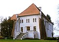
Castle of the Górka family


1.jpg)

sons and daughters of the town
- Wacław z Szamotuł (around 1526 – around 1560), Polish composer and poet
- John Johnston (1603–1675), naturalist and historian of Scottish descent
- Theophil Magdzinski (1818–1889), member of the Reichstag and Landtag
- Philipp Scharwenka (1847–1917), composer and music teacher
- Xaver Scharwenka (1850–1924), composer and pianist
- Hans Groß (1860–1924), airship designer
- Siegmund Labisch (1863–1942), rabbi and photographer, victim of National Socialism
- Maksymilian Ciężki (1898–1951), Polish cryptanalyst
- Alexander Hollaender (1898–1986), American radiation biologist and biophysicist
- Janusz Grabiański (1929–1976), Polish illustrator
- Marlis Heide Schmidt (1943–1996), translation scholar
- Małgorzata Braunek (1947-2014), Polish actress
- Jakub Rutnicki (* 1978), Polish politician.
literature
- Heinrich Wuttke : City book of the country Posen. Codex diplomaticus: General history of the cities in the region of Poznan. Historical news from 149 individual cities . Leipzig 1864, pp. 430-431.
Web links
Individual evidence
- ^ A b c d e Heinrich Wuttke : City book of the country of Posen. Codex diplomaticus: General history of the cities in the region of Poznan. Historical news from 149 individual cities . Leipzig 1864, pp. 430-431.
- ^ A b c Michael Rademacher: German administrative history from the unification of the empire in 1871 to the reunification in 1990. pos_samter.html. (Online material for the dissertation, Osnabrück 2006).
- ↑ Community encyclopedia of the administrative districts of Allenstein, Danzig, Marienwerder, Posen, Bromberg and Oppeln: based on the results of the census of December 1, 1910 and other official sources . Publishing house of the Royal Statistical Office, Berlin 1912, p. 87 f . ( gda.pl [accessed March 4, 2018]).