
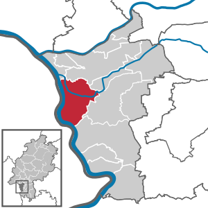
Trebur
| coat of arms | Germany map | |
|---|---|---|
.svg)
|
Coordinates: 49 ° 55 ' N , 8 ° 25' E |
|
| Basic data | ||
| State : | Hesse | |
| Administrative region : | Darmstadt | |
| Circle : | Gross-Gerau | |
| Height : | 86 m above sea level NHN | |
| Area : | 50.14 km 2 | |
| Residents: | 13,338 (Dec. 31, 2019) | |
| Population density : | 266 inhabitants per km 2 | |
| Postal code : | 65468 | |
| Area code : | 06147 | |
| License plate : | GG | |
| Community key : | 06 4 33 014 | |
| Address of the municipal administration: |
Herrngasse 3 65468 Trebur |
|
| Website : | ||
| Mayor : | Jochen Engel ( Free Voters ) | |
| Location of the municipality of Trebur in the Groß-Gerau district | ||
  |
||

Trebur (dialect: Trewwer ) is a municipality in the Groß-Gerau district in southern Hesse .
geography
Geographical location
The community is located in the Rhine-Main area and belongs to the Hessian Ried . The distance to the cities of Mainz , Wiesbaden , Frankfurt am Main and Darmstadt is around 20 to 30 kilometers.
Neighboring communities
Trebur borders the city of Ginsheim-Gustavsburg and the city of Rüsselsheim am Main in the north, the municipality of Nauheim and the city of Groß-Gerau in the east, the city of Riedstadt in the south , and the cities of Oppenheim and Nierstein and the municipalities of Nackenheim in the west and Bodenheim (all districts of Mainz-Bingen ).
Community structure
Trebur consists of the four districts of Astheim , Geinsheim with the Kornsand residential area , Hessenaue and the core municipality of Trebur and houses around 13,000 residents in around 6,100 households.
climate
| Trebur | ||||||||||||||||||||||||||||||||||||||||||||||||
|---|---|---|---|---|---|---|---|---|---|---|---|---|---|---|---|---|---|---|---|---|---|---|---|---|---|---|---|---|---|---|---|---|---|---|---|---|---|---|---|---|---|---|---|---|---|---|---|---|
| Climate diagram | ||||||||||||||||||||||||||||||||||||||||||||||||
| ||||||||||||||||||||||||||||||||||||||||||||||||
|
Average monthly temperatures and rainfall for Trebur
Source:
|
||||||||||||||||||||||||||||||||||||||||||||||||||||||||||||||||||||||||||||||||||||||||||||||||||||||||||||||||||||||||||||||||||||||||||||||||||||||
history

The place Trebur is mentioned for the first time in 829 in a document from King Ludwig the Pious . In the historical documents Trebur is mentioned in the following centuries with the following place names, among others : Triburen and Triburi fiscus in the Lorsch Codex for the period from 830 to 850, Triburias in the years 874 and 882, Triburium 1248, Dribure 1273, Trebure 1295, Tribor 1433, Tribber 1469, Trebornn 1516, Trebber 1550 and Trebur from 1553.
A royal palace had stood in Trebur since the 9th century . It emerged from a royal court with an extensive fiscal district, which also includes today's Astheim district. From the time between 829 and 1077 57 stays of the king and some imperial diets are known, some of which had imperial historical significance. King Heinrich IV was particularly connected to Trebur, where he was elected king in 1053 and married in 1066. In 1076, opposition princes forced him to settle his conflict with the Pope at the Prince's Day in Trebur , which resulted in the “ walk to Canossa ”.
As a result, Trebur lost its importance as a royal court. Apart from the anti-king Rudolf von Rheinfelden , no other king visited the Palatinate. Trebur was pledged together with the Palatinate in 1248 to the County of Katzenelnbogen . The pledge was never redeemed, the counts were able to acquire further sovereign rights in 1422. The Katzenelnbogen inheritance fell to the Landgraviate of Hesse with Trebur in 1479 . In 1527 Count Philipp III. von Hanau-Lichtenberg his rights in Trebur and other rights with Elector Ludwig V of the Palatinate against half of the village of Altheim , which is assigned to the Hanau office of Babenhausen . In 1599 the Albanstift zu Mainz sold its estate to Landgrave Ludwig V of Hessen-Darmstadt , who in 1601 sold it on to the Trebur community. In 1771 the Teutonic Order , the Eberbach Monastery and other mainly Mainz church possessions are named as landowners in Trebur . In the year the possession of the Clariss Monastery of St. Klara, which was abolished in 1781, fell to the Landgraviate of Hessen-Kassel . Until 1802 the Eberbach monastery was named as the landowner.
With the Hessian rule, Trebur became part of the Hessian office of Dornberg together with Astheim and Geinsheim. Administratively, Trebur then belonged to the Dornberg Office until 1820 , which from 1816 belonged to the Starkenburg Province of the Grand Duchy of Hesse . District districts were introduced in the Grand Duchy in 1821 and Trebur was assigned to the district of Dornberg .
The statistical-topographical-historical description of the Grand Duchy of Hesse reports on Trebur in 1829:
“Trebur (L. Bez. Dornberg) market town; is 1 1 / 4 hrs from Dornberg, 3 / 4 St. from Rhein and at the confluence of the country of Bach and the black stream. The place has 224 houses and 1,397 inhabitants, who are Lutheran except for 30 Catholics, 2 Reforms and 77 Jews, and among them are 142 farmers, 114 craftsmen and 63 day laborers. Here is a new large church, a boys 'and a girls' school, and a synagogue. - Trebur was an imperial domain [ Curtis villa regia ); There was also a palatium here, the construction of which can be attributed to Emperor Carl the Great. Neither the villa nor the palatium occurs before the 9th century. Emperor Otto III. donated Trebur to the iQuedlinburg Abbey in 985, but the place appears again as a royal property in the times of Henry II (1002-1024). King Wilhelm pledged the imperial village of Trebur to Count Diether III in 1248. from Katzenellenbogen. The bailiff and other high rights were held here by the lords of Munzenberg and Falkenstein; Diether von Isenburg – Büdingen, a Falkenstein inheritance, sold the bailiwick in 1422 to Count Johann III. von Katzenellenbogen around 1200 fl. - The negotiations that were held here are important and of world historical interest. The great church assembly in 822 is documented. King Ludwig the Pious stayed here in 829, camped here against his rebellious son in 832, and awaited his army here in 839 if his son revolted again. This one, Ludwig the German, also stayed here often and, when his sons fell out with him, called a Reichstag here in 871, just as he had a conversation with his sons and grownups here in 875, which, as the purpose, was not which resulted in the appointment of a new Reichstag to Trebur in the same year. Here in 888 Carl the Fat was deposed. A church assembly was called here by Arnulf in 895, which was one of the strangest of the century, and which was attended by twenty-two or twenty-six bishops and about half as many abbots and a multitude of worldly greats and the king himself. Also in the years 897, furthermore 900 and 905, Reichstag took place here. After the departure of the Carolingians, the luster diminished somewhat, but it rose again under the Frankish emperors. Not far from Trebur, near the village of Campen, which had gone out, Conrad II was elected king in 1024. He called in 1031 and 1035 or 1036 national councils, like Heinrich III. In 1045, an imperial assembly in Trebur. At the great imperial assembly of the year 1053, King Heinrich III. Successor chosen. At the Reichstag in 1066, the estates compelled Emperor Heinrich IV to dismiss Bishop Adalbert of Bremen; this emperor also celebrated his wedding here in the same year. Henry V convened a major diet here again in 1119, which was probably the last imperial act that took place here. The palace fell into disrepair, and with it all of Trebur's glories vanished. Trebur had three churches: 1) the St. Albanskirche, located in front of the Flecken, was formerly the parish church and occurs as early as 1184. Abbot Giselbert von St. Alban donated them to the cathedral chapter of Mainz in 1351 and they were canceled in the middle of the 16th century; 2) the Church of St. Mary, or Our Lady, was given to the community as a schoolhouse in 1599; 3) the Church of St. Laurentii; this was later the parish church and in its place the current one was built. "
In 1832 the units were enlarged one more time and circles were created. As a result, Trebur came to the Groß-Gerau district. The provinces, the counties and the administrative districts of the Grand Duchy were abolished on July 31, 1848 and replaced by administrative districts, but this was reversed on May 12, 1852. As a result, Trebur belonged to the Darmstadt administrative district between 1848 and 1852 , before the Groß-Gerau district was again responsible for the higher-level administration. The place remained there until today through all further administrative reforms. The responsible jurisdiction was during the affiliation to Hesse, from 1821 to 1879 the district court Großgerau and since 1879 the district court Groß-Gerau emerged from it .
In the 17th and 18th centuries, Trebur was not only affected by the Thirty Years War and the plague epidemics, but also by the floods of the nearby Rhine. The population was also subjected to multiple reprisals through the Wars of Succession and Succession and the subsequent Napoleonic Wars . The 19th century was also marked by social and economic grievances, which led to a wave of emigration and emigration between 1840 and 1890 . Only the economic upswing in the Rhine-Main area and the associated new jobs allowed a modest prosperity towards the end of the 19th century.
At the beginning of the 20th century, the two world wars and National Socialism nullified these improvements. The absurdity of war and tyranny was demonstrated again at the end of World War II by the grain sand crime, when six politically unpopular civilians were mistreated and executed on March 21, 1945 on the grain sand - two days before the American forces under General Patton captured the bridgehead on the right bank of the Rhine.
After 1945, the reconstruction and integration of hundreds of refugees and displaced persons began . In the course of rapid structural change, the village lost its predominantly rural character and developed into a modern community for workers and employees. The location of the place on the edge of the Rhine-Main area favored this development, especially through the job opportunities in the nearby Opel factory.
In the course of the regional reform in Hesse , the municipalities of Astheim , Geinsheim , Hessenaue and Trebur were merged into one municipality with the name Trebur on January 1, 1977 by the law to reorganize the district of Groß-Gerau . Local districts according to the Hessian municipal code were not established.
Territorial history and administration
The following list gives an overview of the territories in which Trebur was located and the administrative units to which it was subordinate:
- before 1479: Holy Roman Empire , County Katzenelnbogen , Upper County Katzenelnbogen , Amt Dornberg
- from 1479: Holy Roman Empire, Landgraviate of Hesse , Upper County of Katzenelnbogen, Office of Rüsselsheim
- from 1567: Holy Roman Empire, Landgraviate of Hessen-Darmstadt , Upper County of Katzenelnbogen, Office of Rüsselsheim
- from 1803: Holy Roman Empire, Landgraviate Hessen-Darmstadt, Principality of Starkenburg , Rüsselsheim Office
- from 1806: Grand Duchy of Hesse , Principality of Starkenburg, Rüsselsheim Office
- from 1815: German Confederation , Grand Duchy of Hesse, Province of Starkenburg , Rüsselsheim Office
- from 1821: German Confederation, Grand Duchy of Hesse, Starkenburg Province, Dornberg District District (separation between justice ( Groß-Gerau District Court ) and administration)
- from 1832: German Confederation, Grand Duchy of Hesse, Province of Starkenburg, District of Groß-Gerau
- from 1848: German Confederation, Grand Duchy of Hesse, Darmstadt administrative district
- from 1852: German Confederation, Grand Duchy of Hesse, Province of Starkenburg, District of Groß-Gerau
- from 1866: Grand Duchy of Hesse, Starkenburg Province, Groß-Gerau district
- from 1871: German Empire , Grand Duchy of Hesse, Starkenburg Province, Groß-Gerau district
- from 1918: German Empire, People's State of Hesse , Starkenburg Province, Groß-Gerau district
- from 1938: German Empire, People's State of Hesse, Groß-Gerau district (In the course of the regional reform in 1938 , the three Hessian provinces of Starkenburg, Rheinhessen and Upper Hesse are dissolved.)
- from 1945: American occupation zone , Greater Hesse , Darmstadt administrative district, Gross-Gerau district
- from 1949: Federal Republic of Germany , State of Hesse , Darmstadt district, Groß-Gerau district
population
Population structure
According to the 2011 census , there were 13,095 residents in Trebur on May 9, 2011. Among them were 639 (4.9%) foreigners, of whom 359 came from outside the EU , 177 from other European countries and 100 from other countries. 7.4% of the German residents had a migration background . The inhabitants lived in 5751 households. Of these, 1724 were single households , 1842 couples without children and 1699 couples with children, as well as 405 single parents and 81 shared apartments .
Population development
| • 1629: | 158 house seats |
| • 1791: | 1035 inhabitants |
| • 1800: | 1052 inhabitants |
| • 1806: | 1215 inhabitants, 220 houses |
| • 1829: | 1397 inhabitants, 244 houses |
| • 1867: | 1785 inhabitants, 293 houses |
| Trebur: Population from 1791 to 2018 | ||||
|---|---|---|---|---|
| year | Residents | |||
| 1791 | 1,035 | |||
| 1800 | 1,052 | |||
| 1806 | 1,215 | |||
| 1829 | 1,397 | |||
| 1834 | 1,540 | |||
| 1840 | 1,595 | |||
| 1846 | 1,719 | |||
| 1852 | 1,599 | |||
| 1858 | 1,567 | |||
| 1864 | 1,725 | |||
| 1871 | 1,827 | |||
| 1875 | 1,788 | |||
| 1885 | 1,866 | |||
| 1895 | 1,935 | |||
| 1905 | 2,079 | |||
| 1910 | 2.211 | |||
| 1925 | 2,413 | |||
| 1939 | 2,648 | |||
| 1946 | 3,174 | |||
| 1950 | 3,479 | |||
| 1956 | 3,559 | |||
| 1961 | 3.812 | |||
| 1967 | 4,235 | |||
| 1970 | 4,454 | |||
| 1972 | 4,480 | |||
| 1976 | 9,713 | |||
| 1984 | 10,970 | |||
| 1992 | 11,445 | |||
| 2000 | 12,700 | |||
| 2005 | 12,909 | |||
| 2010 | 13.163 | |||
| 2011 | 13,095 | |||
| 2015 | 13,116 | |||
| 2018 | 13,743 | |||
| Data source: Historical municipality register for Hesse: The population of the municipalities from 1834 to 1967. Wiesbaden: Hessisches Statistisches Landesamt, 1968. Further sources:; 1972 :; 1976 :; 1984 :; 1992 :; 2000 :; 2005 :; 2010 :; 2011 census; 2015 :; 2018: From 1976 including the towns incorporated into Hesse as part of the regional reform . | ||||
Religious affiliation
| • 1829: | 1288 Lutheran (= 92.20%), 2 Reformed (= 0.14%), 77 Jewish (= 5.51%) and 30 Catholic (= 2.15%) residents |
| • 1961: | 2982 (= 78.23%) Protestant and 726 (= 19.05%) Catholic residents |
| • 2011: | 5200 Protestant (= 39.8%), 3190 Catholic (= 24.4%), 4370 other (= 33.4%) residents |
Gainful employment
The municipality in comparison with the district, administrative district Darmstadt and Hesse:
| year | local community | district | Administrative district | Hesse | |
|---|---|---|---|---|---|
| Employees subject to social security contributions | 2017 | 1,982 | 98,042 | 1,695,567 | 2,524,156 |
| Change to | 2000 | −6.2% | + 5.4% | + 16.1% | + 16.0% |
| of which full-time | 2017 | 72.8% | 75.9% | 72.8% | 71.8% |
| of which part-time | 2017 | 27.2% | 24.1% | 27.2% | 28.2% |
| Only marginally paid employees | 2017 | 550 | 13,048 | 224.267 | 372.991 |
| Change to | 2000 | + 57.1% | −9.6% | + 9.0% | + 8.8% |
| Branch | year | local community | district | Administrative district | Hesse |
|---|---|---|---|---|---|
| Manufacturing | 2000 | *)% | 43.8% | 27.0% | 30.6% |
| 2017 | 26.7% | 33.2% | 20.4% | 24.3% | |
| Commerce, hospitality and transport | 2000 | 38.0% | 27.6% | 26.4% | 25.1% |
| 2017 | 26.9% | 27.9% | 24.7% | 23.8% | |
| Business services | 2000 | 31.0% | 14.0% | 25.1% | 20.2% |
| 2017 | 21.1% | 19.9% | 31.6% | 26.1% | |
| other services | 2000 | 14.8% | 13.7% | 20.1% | 22.5% |
| 2017 | 20.3% | 18.6% | 23.0% | 25.4% | |
| Other (or without assignment) | 2000 | 16.2% | 1.0% | 1.4% | 1.5% |
| 2017 | 5.0% | 0.5% | 0.3% | 0.4% |
*) anonymized
politics
Community representation
The local elections on March 6, 2016 produced the following results, compared to previous local elections:
| Parties and constituencies | % 2016 |
Seats 2016 |
% 2011 |
Seats 2011 |
% 2006 |
Seats 2006 |
% 2001 |
Seats 2001 |
||
|---|---|---|---|---|---|---|---|---|---|---|
| CDU | Christian Democratic Union of Germany | 28.2 | 9 | 35.1 | 11 | 34.1 | 13 | 29.4 | 11 | |
| SPD | Social Democratic Party of Germany | 23.1 | 7th | 34.2 | 11 | 39.2 | 14th | 47.2 | 18th | |
| GLT | Green List Trebur | 14.2 | 4th | 24.2 | 7th | 19.5 | 7th | 14.6 | 5 | |
| FDP | Free Democratic Party | 8.9 | 3 | 6.6 | 2 | 7.2 | 3 | 8.8 | 3 | |
| FW | Free voters | 25.6 | 8th | - | - | - | - | - | - | |
| total | 100.0 | 31 | 100.0 | 31 | 100.0 | 37 | 100.0 | 37 | ||
| Voter turnout in% | 49.5 | 46.3 | 47.1 | 55.6 | ||||||

For the first time since incorporation, the CDU became the strongest party in the municipality in the 2011 local elections. In 2016, the free voters ran for the first time in a local election in Trebur.
mayor
The mayor of the municipality of Trebur has been Jochen Engel (Free Voters) since June 3, 2019. He was elected to office on January 27, 2019 after his predecessor Carsten Sittmann did not stand for re-election. The predecessors in the previous terms of office were:
- 2013–2019: Carsten Sittmann (CDU)
- 2000–2013: Jürgen Arnold
- 1996–2000: Willi Girresch (SPD)
badges and flags

coat of arms
Blazon : "In red a golden ring from which three waved golden ribbons extend in the shape of a goblet to the edges of the shield .."
The coat of arms of the municipality of Trebur in the Groß-Gerau district was approved by the Hessian Ministry of the Interior in 1927. After the territorial reform it was approved again on August 15, 1984.
In its current form it was designed by the heraldist Georg Massoth.
The old market town was originally an imperial estate and came under the rule of the Counts of Katzenelnbogen in the 13th century. In the three court seals, the first of which is dated 1511, there was Saint Lawrence with the rust and a crosier or palm branch. The current coat of arms, which was awarded in 1927 with the coloring suggesting Katzenelnbogen, first appeared as a place mark on boundary stones in the 18th century and was repeated in the mayor's seal of the 19th century; However, as Hupp's illustration shows, the three approaches to the ring were shaped like broad-headed nails. Perhaps they should symbolize the so-called Dreidorfmark of Trebur, Nauheim and Mörfelden. Today the picture is interpreted as the confluence of the Rhine, Main and Neckar rivers.
flag
The flag was approved by the Hessian Interior Minister on December 19, 1985 and is described as follows:
"The municipal coat of arms is placed on the red / white flag web in the upper half."
Community partnerships
Trebur has had a partnership with the French municipality of Verneuil-sur-Avre (today: Verneuil d'Avre et d'Iton ) since 1982 and with the Romanian city of Jimbolia since 2017 .
Culture and sights
Buildings
- The Protestant Laurentius Church probably emerged from the earlier Palatine Chapel. Parts of the church that have been preserved date from the early 11th century . This makes the church one of the few architectural testimonies from the Ottonian period .
- The Catholic parish church of St. Petrus in Ketten in the Astheim district is a baroque parish church, built in 1651. Especially the baroque high altar, the remarkable ceiling paintings, the Dreymann organ and a late Gothic sculpture of St. Martin of Tours are worth seeing. The baroque jewel of St. Peter in chains, three little houses of saints , figures of saints and wayside crosses symbolize the Catholic Astheim and its former membership of the Mainz Electorate in the evangelical Hesse.
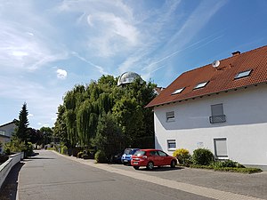
- The T1T is in Trebur - with a mirror diameter of 1.20 meters, it is one of the largest publicly accessible telescopes in Europe. The T1T is operated by the Michael Adrian Observatory of the Trebur Astronomy Foundation. The asteroid with the number 142408 discovered in 2002 at the Trebur observatory bears the name “Trebur”: (142408) Trebur.
- A planetary path has been set up around the roundabout at the northern exit towards Rüsselsheim am Main .
- The Hessian part of the German Half-timbered Road begins in Trebur .
- The Zeppelin monument on Kornsand.
- The local history museum at Nauheimer Straße 14 in which changing exhibitions on the subject of homeland and history are presented.
- Not far from the connecting road Kornsand-Geinsheim at 49 ° 52 ′ 11.4 ″ N , 8 ° 23 ′ 0.6 ″ E , the SWR operates a transmission system for VHF that uses a 138 meter high, guyed steel truss mast with a triangular cross-section as an antenna carrier. This transmission mast was originally part of the four-mast directional antenna built in 1964 for the Bodensee transmitter in Meßkirch-Rohrdorf. It was dismantled in the 1970s and rebuilt in Trebur in 1981.

Laurentiuskirche seen from the Schwarzbach
Michael Adrian Observatory
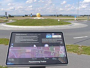
Planet path: legend and sun

Trebur Local History Museum in Nauheimer Strasse 14
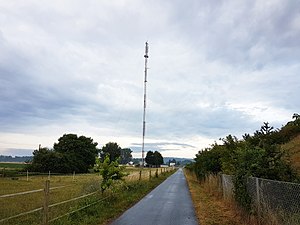
FM transmitter of the SWR between Geinsheim and Kornsand


Sports
The football club TSV 05 Trebur or depending on the age group, the SG Trebur / Astheim or JSG Trebur / Geinsheim / Waller sites is currently in the county league actively Gross Gerau. The association TV 1886 Trebur has departments in handball , gymnastics , basketball , athletics , in several dance sports , aikido , rope skipping and tennis .
Regular events
Below is a selection of the regular Trebur events:
Carnival (Fifth Season)
- A carnival parade takes place on Shrove Sunday in the Astheim district . In addition to the parade, there are also some carnival events.
- The Astheim Carnival Association annually organizes 2 ladies' meetings, a ceremonial meeting, children's meeting and senior meeting in the Mayor-Jakob-Roos Hall in Astheim
- The Trewwerer Elves hold an annual meeting in their own home in Trebur.
spring
- On May 27, 2018, Trebur and its districts of Geinsheim and Astheim were, as in 2014, part of the biennial action Der Kreis rolls . The bike route ran right through the town, many associations and institutions participated with stands and exhibitions.
summer
- The municipality of Trebur has been organizing the "Trebur Open Air" festival on the square next to the Fritz Becker outdoor pool since 1993, where around 50 bands play every year. The festival is under the direction of the community's child and youth development team in cooperation with the Trebur e. V. organized. Since it is a non-profit event, all of the work is done by around 200 volunteers. The open air draws around 7,000 people to Trebur every year.
- Trebur finds the notch on Sunday after Lawrence, August 10, instead. Laurentius is the anniversary of the death of St. Lawrence . The 10-day notch (Saturday to Tuesday with the Kerwedorf) will end on the following weekend with the so-called post-notch . The main actors are the so-called Kerweborsch and Kerwemädcher . For the active Kerweborsch and Kerwemädscher, the curb ends with the traditional "laying" of the Kerweb tree on Post-Kerwemontag.
autumn
- Since 2001 the Trebur trade association has been holding a large street festival with a colorful program of fashion shows, dance performances and a Sunday shopping in the center of Trebur under the motto "Fun uff de Gass" at the end of September.
- At the end of the Oktoberfest season, the Trebur e. V. held the "Treburer Oktoberfest" in the large festival tent on the last weekend in October.
winter
- In mid-December the Christmas market takes place in the museum courtyard in Trebur , which has been organized by the Kerweborsch since 2012 .
Economy and Infrastructure
Land use
The municipal area covers a total area of 5014 hectares, of which in hectares are:
| Type of use | 2011 | 2015 | |
|---|---|---|---|
| Building and open space | 341 | 346 | |
| from that | Living | 183 | 183 |
| Business | 22nd | 24 | |
| Operating area | 53 | 33 | |
| from that | Mining land | 45 | 24 |
| Recreation area | 31 | 32 | |
| from that | Green area | 21st | 21st |
| traffic area | 261 | 260 | |
| Agricultural area | 3673 | 3567 | |
| from that | moor | 0 | 0 |
| pagan | 0 | 0 | |
| Forest area | 136 | 222 | |
| Water surface | 412 | 449 | |
| Other use | 107 | 106 | |
Economic structure
The economy and infrastructure in Trebur are shaped by the fact that it belongs to the Frankfurt-Rhein-Main metropolitan area as well as by its proximity to Frankfurt Airport and the Opel works in Rüsselsheim am Main.
Trebur was considered in February 2006 for the possible location of a nuclear power plant .
Road traffic
State road 3040 from Ginsheim to Nauheim runs through Trebur and the municipality in a west-east direction and state road 3012 from Rüsselsheim am Main to Geinsheim in north-south direction . In Geinsheim, the latter meets state road 3094 , which begins in Groß-Gerau and ends at the grain sand at the Rhine ferry . The Rhine ferry, which operates during the day, provides a connection to the federal highways 9 and 420 on the left bank of the Rhine near Oppenheim and Rheinhessen .
hospital
Trebur does not have its own hospital. The closest hospitals are the GPR Klinikum Rüsselsheim and the district hospital in neighboring Groß-Gerau.
Geothermal energy

Between March and September 2016, deep drilling for a geothermal power plant east of Trebur took place on behalf of the Groß-Gerau overland plant . The first deep geothermal power plant in Hessen was to be built here. The drilling was stopped after a depth of over 4000 meters because insufficient thermal water was found. This led to the termination of the project.
Personalities
- Wilhelm Diehl (1871–1944), Hessian historian and Protestant prelate (grew up in Kornsand )
- Leia Holtwick (* 2002), German actress and model (lives in Trebur)
- Boris Kolb (* 1979), football player (born in Trebur)
- Gerold Reichenbach (* 1953), state and federal politician ( SPD ) (born in Geinsheim am Rhein )
- Irmgard Schäfer , dialect poet, linguist and columnist (lived in Geinsheim am Rhein )
literature
- Society Home and History: Archive Pictures Trebur. Sutton Verlag, Erfurt 2006, ISBN 978-3-86680-043-4 .
- Wolfgang Kraft, Dieter Wolf : 1150 years of Trebur - a contribution to the oldest story "Triburs". In: Society Home and History e. V. Trebur (Hrsg.): Annual report 1973. Society Heimat und Geschichte e. V. Trebur. Trebur 1973/1974.
- Literature on Trebur in the Hessian Bibliography
- Literature by and about Trebur in the catalog of the German National Library
Web links
- Trebur. In: Website of the district of Groß-Gerau
- Trebur, district of Groß-Gerau. Historical local dictionary for Hessen. In: Landesgeschichtliches Informationssystem Hessen (LAGIS).
- Information on the municipality of Trebur. In: Hessisches Gemeindelexikon. HA Hessen Agentur GmbH , 2016.
- Link catalog on Trebur at curlie.org (formerly DMOZ )
Individual evidence
- ↑ Hessian State Statistical Office: Population status on December 31, 2019 (districts and urban districts as well as municipalities, population figures based on the 2011 census) ( help ).
- ↑ With humor through village and time. In: Darmstädter Echo, Monday, August 11, 2014. ( Page no longer available , search in web archives )
- ↑ Climate table on wetter24.de
- ↑ Climate table on diebestereisezeit.de
- ↑ a b c d e f g Trebur, district of Groß-Gerau. Historical local dictionary for Hessen. (As of March 23, 2018). In: Landesgeschichtliches Informationssystem Hessen (LAGIS).
- ↑ a b c History of Trebur at a glance. (No longer available online.) Trebur municipality, archived from the original ; accessed in November 2012 .
- ^ A b c Georg Wilhelm Justin Wagner : Statistical-topographical-historical description of the Grand Duchy of Hesse: Province of Starkenburg . tape 1 . Carl Wilhelm Leske, Darmstadt October 1829, OCLC 312528080 , p. 245 ( online at google books ).
- ↑ Law on the reorganization of the district of Groß-Gerau (GVBl. II 314–32) of July 26, 1974 . In: The Hessian Minister of the Interior (ed.): Law and Ordinance Gazette for the State of Hesse . 1974 No. 22 , p. 314 , § 6 ( online at the information system of the Hessian state parliament [PDF; 1.5 MB ]).
- ^ Michael Rademacher: German administrative history from the unification of the empire in 1871 to the reunification in 1990. State of Hesse. (Online material for the dissertation, Osnabrück 2006).
- ^ Grand Ducal Central Office for State Statistics (ed.): Contributions to the statistics of the Grand Duchy of Hesse . tape 1 . Großherzoglicher Staatsverlag, Darmstadt 1862, DNB 013163434 , OCLC 894925483 , p. 43 ff . ( Online at google books ).
- ↑ a b List of offices, places, houses, population. (1806) HStAD inventory E 8 A No. 352/4. In: Archive Information System Hessen (Arcinsys Hessen), as of February 6, 1806.
- ↑ Population by nationality group: Trebur. In: Zensus2011. Bavarian State Office for Statistics , accessed in May 2015 .
- ↑ Migration background in%: Trebur. In: Zensus2011. Bavarian State Office for Statistics , accessed in May 2015 .
- ^ Households by family: Trebur. In: Zensus2011. Bavarian State Office for Statistics , accessed in May 2015 .
- ↑ Hessen-Darmstadt state and address calendar 1791 . In the publishing house of the Invaliden-Anstalt, Darmstadt 1791, p. 127 ( online in the HathiTrust digital library ).
- ↑ Hessen-Darmstadt state and address calendar 1800 . In the publishing house of the Invaliden-Anstalt, Darmstadt 1800, p. 131 ( online in the HathiTrust digital library ).
- ^ Ph. AF Walther : Alphabetical index of the residential places in the Grand Duchy of Hesse . G. Jonghaus, Darmstadt 1869, OCLC 162355422 , p. ss ( online at google books ).
- ^ Local elections 1972; Relevant population of the municipalities on August 4, 1972 . In: The Hessian Minister of the Interior (ed.): State Gazette for the State of Hesse. 1972 No. 33 , p. 1424 , point 1025 ( online at the information system of the Hessian state parliament [PDF; 5.9 MB ]).
- ↑ Local elections 1977; Relevant population figures for the municipalities as of December 15, 1976 . In: The Hessian Minister of the Interior (ed.): State Gazette for the State of Hesse. 1976 No. 52 , p. 2283 , point 1668 ( online at the information system of the Hessian state parliament [PDF; 10.3 MB ]).
- ^ Local elections 1985; Relevant population of the municipalities as of October 30, 1984 . In: The Hessian Minister of the Interior (ed.): State Gazette for the State of Hesse. 1984 No. 46 , p. 2175 , point 1104 ( online at the information system of the Hessian state parliament [PDF; 5.5 MB ]).
- ↑ local elections 1993; Relevant population of the municipalities as of October 21, 1992 . In: The Hessian Minister of the Interior (ed.): State Gazette for the State of Hesse. 1992 No. 44 , p. 2766 , point 935 ( online at the information system of the Hessian state parliament [PDF; 6.1 MB ]).
- ↑ a b municipality data sheet: Trebur. (PDF; 222 kB) In: Hessisches Gemeindelexikon. HA Hessen Agency GmbH
- ^ The population of the Hessian communities (June 30, 2005). (No longer available online.) In: Hessisches Statistisches Landesamt . Archived from the original .
- ^ The population of the Hessian communities (June 30, 2010). (No longer available online.) In: Hessisches Statistisches Landesamt . Archived from the original .
- ^ Population figures : Trebur. In: Zensus2011. Bavarian State Office for Statistics , accessed in May 2015 .
- ^ The population of the Hessian communities (June 30, 2015). (No longer available online.) In: Hessisches Statistisches Landesamt . Archived from the original .
- ↑ The congregation introduces itself. Municipality of Trebur, accessed on May 17, 2020 (including population).
- ↑ Religion: Trebur. In: Zensus2011. Bavarian State Office for Statistics , accessed in May 2015 .
- ^ Result of the municipal election on March 6, 2016. 433014 Trebur. Hessian State Statistical Office, accessed in April 2016 .
- ^ Result of the municipal election of March 27, 2011. 433014 Trebur. Hessian State Statistical Office, accessed in October 2019 .
- ^ Result of the municipal election of March 26, 2006. 433014 Trebur. Hessian State Statistical Office, accessed in October 2019 .
- ↑ Results of the municipal elections of 2001 and 1997. (No longer available online.) Hessian State Statistical Office, archived from the original ; accessed in October 2019 .
- ↑ The fifth chapter of Mayors begins with Jochen Engel in Trebur. In: echo-online.de. Darmstädter Echo , May 19, 2019, accessed on May 14, 2020 .
- ↑ Mayoral elections in Trebur. Hessian State Statistical Office , accessed in October 2019 .
- ^ Karl Ernst Demandt , Otto Renkhoff : Hessisches Ortswappenbuch. C. A. Starke Verlag, Glücksburg / Ostsee 1956.
- ^ Approval of a coat of arms of the municipality of Trebur in the district of Groß-Gerau from August 15, 1984 . In: The Hessian Minister of the Interior (ed.): State Gazette for the State of Hesse. 1984 No. 36 , p. 1734 , point 866 ( online at the information system of the Hessian state parliament [PDF; 3.7 MB ]).
- ^ Approval of a flag of the municipality of Trebur, district of Groß-Gerau from December 19, 1985 . In: The Hessian Minister of the Interior (ed.): State Gazette for the State of Hesse. 1986 No. 2 , p. 74 , point 26 ( online at the information system of the Hessian state parliament [PDF; 4.2 MB ]).
- ↑ Website of the T1T observatory
- ↑ Trebur Planet Trail. In: website. Trebur municipality, accessed October 2019 .
- ^ "The circle is rolling": Bus timetable changes in the Groß-Gerau district on May 27th. In: www.echo-online.de. VRM , May 24, 2018, accessed December 4, 2018 .
- ↑ Hessisches Statistisches Informationssystem In: Statistics.Hessen.
- ^ Rheinauen Trebur - nuclear power plant in Trebur - unthinkable Every year new plans for the Rhine foreland. (No longer available online.) In: Website. Trebur municipality, archived from the original ; accessed in November 2012 .
- ↑ ÜWG: Geothermal energy Groß-Gerau. In: www.geothermie-trebur.de. Retrieved November 23, 2016 .

