
Gernsheim
| coat of arms | Germany map | |
|---|---|---|

|
Coordinates: 49 ° 45 ' N , 8 ° 29' E |
|
| Basic data | ||
| State : | Hesse | |
| Administrative region : | Darmstadt | |
| Circle : | Gross-Gerau | |
| Height : | 89 m above sea level NHN | |
| Area : | 40.11 km 2 | |
| Residents: | 10,558 (Dec. 31, 2019) | |
| Population density : | 263 inhabitants per km 2 | |
| Postal code : | 64579 | |
| Area code : | 06258 | |
| License plate : | GG | |
| Community key : | 06 4 33 004 | |
| LOCODE : | DE GHM | |
| City structure: | 3 districts | |
City administration address : |
Stadthausplatz 1 64579 Gernsheim |
|
| Website : | ||
| Mayor : | Peter Burger ( CDU ) | |
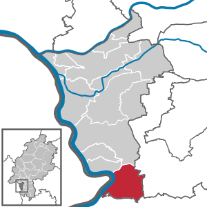
| Location of the city of Gernsheim in the Groß-Gerau district | ||
  |
||

Gernsheim is a town in the Groß-Gerau district in southern Hesse and is located on the Rhine . As an addition, Gernsheim bears the name “Schöfferstadt”, which it was given in 2003 by the Hessian Ministry of the Interior . He refers to the important son of the city Peter Schöffer .
geography

location
Gernsheim is located about 18 km southwest of Darmstadt within the Upper Rhine Plain in the middle of the Hessian Ried . It is located on the east bank of the Rhine - viewed downstream between its district of Klein-Rohrheim in the south with the municipality of Groß-Rohrheim on the other side and the municipality of Biebesheim am Rhein in the north-northwest; Eastern neighboring with Haehnlein a community part of Alsbach . On the right bank of the Rhine, the Hammerau Old Rhine with the Hammer Aue nature reserve from Gernsheim and Groß-Rohrheim extends in the Gernsheim urban area and in the municipal area of Groß-Rohrheim .

Location of Gernsheim on the eastern bank of the Rhine

Neighboring communities
Gernsheim borders in the north on the municipality of Biebesheim and the city of Riedstadt (all districts Groß-Gerau ), in the east on the city Pfungstadt and the communities Bickenbach and Alsbach-Hähnlein (all districts Darmstadt-Dieburg ), in the south on the city of Bensheim and the Municipalities of Einhausen and Groß-Rohrheim (all Bergstrasse district ), and in the west to the municipality of Hamm am Rhein ( Alzey-Worms district ).
City structure
Gernsheim consists of the districts Allmendfeld , Gernsheim and Klein-Rohrheim .
history

A Neolithic settlement was discovered in the Klein-Rohrheim district while a bypass was being built . Ten houses from around 5300 BC It can be proven that they were erected at regular intervals of 12 to 15 m from each other. It is still unclear whether they existed at the same time. Outer trenches typical for the oldest ceramic tape were dug, post holes up to a meter deep. The construction of the houses could be assigned to the Flomborn level, which follows the oldest ceramic band. Therefore, dating near the transition between the two levels is likely.
The forerunner of today's city of Gernsheim was a Roman fort from the first century AD. A column fragment excavated in the Siegfriedstrasse in 1972 still dates from this time. The fort was abandoned in the 3rd century at the latest when the Romans abandoned the right bank of the Rhine. The foundations of Fort Gernsheim were discovered on August 27, 2014 by archaeologists from the University of Frankfurt am Main in the area of Nibelungenstrasse. During an excavation in 2015, a Roman village near the fort was also discovered, which was probably inhabited from the 1st to the 3rd century AD.
After the Great Migration , Gernsheim became a Franconian royal court (first mentioned in 852 in a document by Ludwig the German ). In 908 this came into the possession of the Lorsch Monastery (mentioned in the Lorsch Codex ) and in 1232 under the rule of Kurmainz , which lasted until the Reichsdeputationshauptschluss 1803. This explains why the Mainz wheel appears in the coat of arms today. Gernsheim received town charter in 1356 with a certificate from Charles IV ; it was fortified and received a moated castle as the electoral residence.
see also Burg Gernsheim , Burg Falkenau
The place was called Heim des Gerin / Gerun in 830/50 in an early Franconian period , with a long e and short i / u. Spellings were 852 Gerunesheim, between 830/50 Gernesheim, 871 Gerinesheim / Kerinesheim. In an old script about the city, here called Gernersheim , it says in Latin: "d) the well-known Petri Schoifferi, the perfect and famous typographer in the country, has now called the place Gernsheim", Gernsheim for the first time from 1283.

Peter Schöffer , who worked for Johannes Gutenberg when he invented the printing press, was born in Gernsheim around 1425 . The city of Gernsheim, which in 1836 placed a stone monument for him on the square that is named after him today (carved by Johann Baptist Scholl from Darmstadt), celebrates the printer who died in Mainz in 1503 as the city's greatest son and is now officially called Schöfferstadt .
In the Thirty Years War Gernsheim was sacked by the Swedes. During the Palatinate War of Succession , it was set on fire by the troops of General Ezéchiel de Mélac in 1689.
In 1803 Gernsheim came to the Landgraviate of Hessen-Darmstadt (from 1806 Grand Duchy of Hessen ) in the course of the secularization of the electoral territory of the Archbishops of Mainz . Administratively Gernsheim belonged to the office of Gernsheim until 1821 . As a result of the administrative reform of 1821 in the Grand Duchy of Hesse, the city was assigned to the district of Bensheim in the Starkenburg province .
The statistical-topographical-historical description of the Grand Duchy of Hesse reports on Gernsheim in 1829:
“Gernsheim (L. Bez. Bensheim) city; is located in a flat area on the influence of the angle Bach in the Rhine, 3 pieces of Bensheim and 4 1 / 2 St. of Darmstadt. With the courtyards, the city has 322 houses and 2893 inhabitants, all of which are Catholic except for 69 Lutherans, 9 Reforms and 52 Jews. There are 52 farmers, 21 linen weavers, 18 bakers, 11 butchers, 5 rope makers, 28 shoemakers, 12 blacksmiths, 44 boatmen and fishermen, 5 ship builders, 2 hat makers, etc. The houses are partly beautiful and the streets fairly wide. The city consists of the suburb and the city proper, which the latter is in part provided with ditches and ramparts and divided into four quarters. The main buildings include: the beautiful parish church, which was completed in 1753 and has a high, magnificent tower, the town hall built in 1700 and the former Domkapitelsche factories. Gernsheim has an industrial school and good peat graves. Here is a Rhine crossing and every week a market ship goes to Mainz. The fruit markets that are held here weekly are significant; Gernsheim also has 3 cattle and grocer's markets every year. Peter Schöffer was born here, Fusts Eidam, who invented the cast letters before 1454. - The Romans seem to have had a strong point of view here. at least one has already found many Roman coins in and near Gernsheim. However, the place first appears by name in 773 in the Heppenheimer mark description. Several emperors and kings counted him among their royal courts. In 1071, Emperor Heinrich IV confirmed several items of goods to Gernsheim to Lorsch Abbey. After this monastery was fully owned by the town, it established its own bailiwick here, with which the noble von Bickenbach family was enfeoffed. With the Lorsch monastery, Gernsheim came to the archbishopric of Mainz in 1232, along with the patronage that the monastery received through exchange in 907, but the hereditary bailiff only in 1283. In 1356, Emperor Carl IV granted the town of Gernsheim town rights, just as the town later received market privileges . The archbishopric also remained in the possession of Gernsheim until the elector Adolph II pledged the city and the office of Gernsheim together with the Rheinzolle for 40,000 florins to Count Philipp von Katzenellenbogen in 1465. So the city came to Hesse and stayed there until Elector Albrecht of Mainz, in 1520, redeemed the whole thing. After the Bickenbach man tribe had left Erbach, the Rhine journey had come to Erbach, from this in 1522 to Churmainz and from there in 1579 to Hesse by comparison. During the Thirty Years' War, the city was gradually occupied by various troops; In 1647 the fortress works had to be razed and in 1689 the town was almost entirely turned into a heap of ashes by Melac's murderous hordes. The city was previously heavily fortified and had a fortress separated from the city, which was provided with wide moats, a drawbridge, strong masonry and a high tower. In former times there was a gold fishing and gold washing business in and near Gernsheim. Nearby was the considerable Frenkenfeld farm, which had now been abandoned. In 1802 the city of Mainz came to Hesse. "
1832 Province Starkenburg was then in circles divided, and Gernsheim belonged to the circle Bensheim . It then belonged to this until 1874, only interrupted by the division of Starkenburg into administrative districts. From 1848 to 1852 it was part of the Heppenheim administrative district . In the course of the reform of the district constitution in the Grand Duchy of Hesse based on the Prussian model in 1874, there was also a new district division. Due to this reform, Gernsheim came to the Groß-Gerau district, to which it still belongs to this day.
The responsible jurisdiction was the district court of Gernsheim from 1839 to 1879, and from 1879 the district court of Gernsheim that emerged from it . After its dissolution in 1938, Gernsheim fell under the jurisdiction of the Groß-Gerau district court .
In the 19th century, the city fortifications were razed, the suburbs expanded, the city was connected to shipping on the Rhine and a railway line, and the first industrial plants were built.
In the final phase of the Second World War in Europe, the American units reached the Rhine between Mainz and Mannheim in mid-March 1945. In preparation for their crossing of the Rhine , most of the Ried communities were shelled by American artillery on March 25th and on the night of March 26th. On March 26, Gernsheim was 40% destroyed.
The reconstruction in the 1950s went rapidly and with Gernsheim took a large number of displaced persons and refugees from the former German eastern territories, whose descendants today maintain an "East German Heimatstube" yet at the Municipal Museum.
Incorporations
In the course of the regional reform in Hesse on December 31, 1971, the two previously independent communities Allmendfeld and Klein-Rohrheim were incorporated into the city of Gernsheim on a voluntary basis. Allmendfeld was founded in 1937, and Klein-Rohrheim was first mentioned in writing about 1200 years ago. For Allmendfeld and Klein-Rohrheim local districts with local advisory council and local councilor were formed according to the Hessian municipal code.
Territorial history and administration
The following list gives an overview of the territories in which Gernsheim was located and the administrative units to which it was subordinate:
- before 1803: Holy Roman Empire , Electorate Mainz , Lower Archbishopric, Upper Office Starkenburg , Office Gernsheim
- from 1803: Holy Roman Empire, Landgraviate of Hessen-Darmstadt (through Reichsdeputationshauptschluss ), Principality of Starkenburg , Office of Gernsheim
- from 1806: Grand Duchy of Hesse , Principality of Starkenburg, Gernsheim Office
- from 1815: German Confederation , Grand Duchy of Hesse, Province of Starkenburg , Gernsheim Office
- from 1821: German Confederation, Grand Duchy of Hesse, Starkenburg Province, Bensheim District District (separation between the judiciary ( Zwingenberg District Court ) and administration)
- from 1832: German Confederation, Grand Duchy of Hesse, Starkenburg Province, Bensheim district
- from 1848: German Confederation, Grand Duchy of Hesse, administrative district of Heppenheim
- from 1852: German Confederation, Grand Duchy of Hesse, Province of Starkenburg, District of Bensheim
- from 1866: Grand Duchy of Hesse, Province of Starkenburg, District of Bensheim
- from 1871: German Empire , Grand Duchy of Hesse, Province of Starkenburg, Bensheim district
- from 1874: German Empire, Grand Duchy of Hesse, Starkenburg Province, Groß-Gerau district
- from 1918: German Empire, People's State of Hesse , Starkenburg Province, Groß-Gerau district
- from 1938: German Reich, People's State of Hesse, Groß-Gerau district (In the course of the regional reform in 1938 , the three Hessian provinces of Starkenburg, Rheinhessen and Upper Hesse were dissolved.)
- from 1945: American occupation zone , Greater Hesse , Darmstadt administrative district, Gross-Gerau district
- from 1949: Federal Republic of Germany , State of Hesse , Darmstadt district, Groß-Gerau district
population
Population structure
According to the 2011 census , there were 9,816 residents in Gernsheim on May 9, 2011. These included 872 (8.9%) foreigners of whom 425 came from outside the EU , 309 from other European countries and 128 from other countries. The inhabitants lived in 4268 households. Of these, 1,293 were single households , 1,255 couples without children and 1,285 couples with children, as well as 346 single parents and 89 shared apartments .
Population development
| • 1806: | 2255 inhabitants, 284 houses (with small pipe home) |
| • 1829: | 2893 inhabitants, 322 houses |
| • 1867: | 3405 inhabitants, 497 houses |
| Gernsheim: Population from 1806 to 2015 | ||||
|---|---|---|---|---|
| year | Residents | |||
| 1806 | 2,255 | |||
| 1829 | 2,893 | |||
| 1834 | 2,847 | |||
| 1840 | 3,059 | |||
| 1846 | 3,385 | |||
| 1852 | 3,488 | |||
| 1858 | 3,567 | |||
| 1864 | 3,557 | |||
| 1871 | 3,420 | |||
| 1875 | 3,277 | |||
| 1885 | 3,499 | |||
| 1895 | 3,750 | |||
| 1905 | 4,188 | |||
| 1910 | 4,197 | |||
| 1925 | 4,743 | |||
| 1939 | 4,905 | |||
| 1946 | 5,983 | |||
| 1950 | 6,378 | |||
| 1956 | 6,723 | |||
| 1961 | 7.104 | |||
| 1967 | 7,416 | |||
| 1971 | 7,628 | |||
| 1972 | 8,349 | |||
| 1976 | 8,152 | |||
| 1984 | 7,980 | |||
| 1992 | 9,066 | |||
| 2000 | 9,400 | |||
| 2005 | 9,603 | |||
| 2010 | 10.161 | |||
| 2011 | 9,816 | |||
| 2015 | 10,066 | |||
| Data source: Historical municipality register for Hesse: The population of the municipalities from 1834 to 1967. Wiesbaden: Hessisches Statistisches Landesamt, 1968. Further sources:; 1972 :; 1976 :; 1984 :; 1992 :; 2000 :; 2005 :; 2010 :; 2011 census; 2015: From 1972 including the towns incorporated into Hesse as part of the regional reform . | ||||
Religious affiliation
| • 1829: | 69 Lutheran (= 2.39%), 9 Reformed (= 0.31%), 52 Jewish (= 1.80%) and 2753 Catholic (= 85.16%) residents |
| • 1961: | 1789 Protestant (= 25.18%), 5221 Catholic (= 73.49%) residents |
| • 2011: | 2815 Protestant (= 28.7%), 3779 Catholic (= 38.5%) residents |
Gainful employment
The municipality in comparison with the district, administrative district Darmstadt and Hesse:
| year | local community | district | Administrative district | Hesse | |
|---|---|---|---|---|---|
| Employees subject to social security contributions | 2017 | 4,057 | 98,042 | 1,695,567 | 2,524,156 |
| Change to | 2000 | + 37.0% | + 5.4% | + 16.1% | + 16.0% |
| of which full-time | 2017 | + 37.0% | 75.9% | 72.8% | 71.8% |
| of which part-time | 2017 | 63.0% | 24.1% | 27.2% | 28.2% |
| Only marginally paid employees | 2017 | 525 | 13,048 | 224.267 | 372.991 |
| Change to | 2000 | −8.5% | −9.6% | + 9.0% | + 8.8% |
| Branch | year | local community | district | Administrative district | Hesse |
|---|---|---|---|---|---|
| Manufacturing | 2000 | 51.1% | 43.8% | 27.0% | 30.6% |
| 2017 | 36.6% | 33.2% | 20.4% | 24.3% | |
| Commerce, hospitality and transport | 2000 | 22.4% | 27.6% | 26.4% | 25.1% |
| 2017 | 39.4% | 27.9% | 24.7% | 23.8% | |
| Business services | 2000 | 9.6% | 14.0% | 25.1% | 20.2% |
| 2017 | 10.5% | 19.9% | 31.6% | 26.1% | |
| other services | 2000 | 14.8% | 13.7% | 20.1% | 22.5% |
| 2017 | 12.0% | 18.6% | 23.0% | 25.4% | |
| Other (or without assignment) | 2000 | 2.1% | 1.0% | 1.4% | 1.5% |
| 2017 | 1.5% | 0.5% | 0.3% | 0.4% |
religion
The first evidence of the existence of a church dates back to 908 when an ecclesia is mentioned. In the historical documents there is a reference to a castle chapel from 1390 and later to the parish church and the Maria Einsiedel pilgrimage chapel. As church patrons are Mary Magdalene for the church and cross-increase mentioned for Maria Einsiedel. The church patronage was held by Liutfried Comes before 908 and then by Lorsch Abbey and from 1232 by the Archbishopric of Mainz . From 1236 the Mainz Cathedral Foundation is also involved.
The Catholic deanery of Rüsselsheim of the diocese of Mainz and the Protestant deanery of Ried of the Evangelical Church in Hesse and Nassau are responsible as church administrations for Gernsheim today .
politics
City Council
The local elections on March 6, 2016 produced the following results, compared to previous local elections:
| Parties and constituencies | % 2016 |
Seats 2016 |
% 2011 |
Seats 2011 |
% 2006 |
Seats 2006 |
% 2001 |
Seats 2001 |
||
|---|---|---|---|---|---|---|---|---|---|---|
| CDU | Christian Democratic Union of Germany | 49.2 | 15th | 42.3 | 13 | 54.2 | 17th | 49.3 | 15th | |
| SPD | Social Democratic Party of Germany | 28.1 | 9 | 28.9 | 9 | 25.8 | 8th | 30.8 | 10 | |
| GREEN | Alliance 90 / The Greens | 13.2 | 4th | 18.1 | 6th | 7.4 | 2 | 8.7 | 3 | |
| FWG | Free voter community eV | 4.53 | 1 | 6.8 | 2 | 6.9 | 2 | 7.6 | 2 | |
| FDP | Free Democratic Party | 5.0 | 2 | 4.0 | 1 | 5.7 | 2 | - | - | |
| total | 100.0 | 31 | 100.0 | 31 | 100.0 | 31 | 100.0 | 31 | ||
| Voter turnout in% | 45.7 | 44.0 | 44.8 | 52.3 | ||||||


mayor
In January 2011, Peter Burger (CDU) was elected to succeed Rudolf Müller (CDU) in the second ballot. Burger was confirmed in office in 2017.
Districts
The following local districts with local advisory board and local councilor according to the Hessian municipal code exist in the municipality:
- Allmendfeld district (areas of the former Allmendfeld municipality ). The local advisory board consists of 9 members.
- Klein-Rohrheim district (areas of the former Klein-Rohrheim community ). The local advisory board consists of 7 members.
flag
In March 1953 the city of Gernsheim was approved by the Hessian Minister of the Interior to fly a flag.
Flag description: "The coat of arms of the city of Gernsheim is on the white central panel of the red-white-red flag cloth."
Twin cities
-
 France , Bar-sur-Aube (Champagne-Ardenne) since 1976
 -
 Poland , Schwetz an der Vistula ( Świecie ) since 2011
Culture and sights
Buildings
The structure of the town center is heterogeneous, which can be explained by the war damage; plaster with flat roofs dominates. Individual historic half-timbered houses from the 18th century have been preserved in Magdalenenstrasse and in the neighboring streets, for example the Zur Krone house (No. 37) with a corresponding emblem and inscription, the complex No. 64–68 and a long building at Peter-Schöffer -Platz (1711) with archway from 1500 and sundial from 1790 (house number 71).
- Parish Church of St. Maria Magdalena
- The church was built from 1750 to 1753 by the Mainz master builder Johann Valentin Thoman . Stylistically, it can be assigned to the formal language of Balthasar Neumann , who was active in the area ( Heusenstamm , Hofheim ): white plaster, alternating with red sandstone on the pilaster strips and portal, three-part west facade with a three-storey tower with oculus, arched windows and onion hood. The transept, side chapels and choir were added in 1887. Glass windows were created by Professor Otto Linnemann from Frankfurt in 1943 .
On March 26, 1945, the church was destroyed by American artillery fire. The reconstruction in the years 1947–1951 was headed by Hugo Becker from Mainz. The new church was consecrated on May 1st, 1951 by Bishop Albert Stohr . Renovation work took place in 2005/2006. The main altar by the local builder Andreas Diettmann (1783) with sculptures by Sebastian Pfaff was taken over to Gernsheim in 1953 by Bürstadt, for whose church it was created. In front of the church is the statue of St. Joseph , Gernsheim's patron saint (restored in 1979 after damage in 1945).
- town hall
- The twelve-axis classical building on the east side of the market square was designed by Georg Moller . It is a reconstruction because the town hall burned down in 1945. It was renovated in 2005/2006.
- Municipal Museum
- The so-called Peter-Schöffer-Haus is located on Peter-Schöffer-Platz and was set up as a museum in 1978 (renovated in 2002/2003 to mark the 500th anniversary of the printer's death). Before that, the building, which houses the city library and fire brigade museum, was the municipal elementary school, which was built in the mid-1830s (the building was inaugurated in 1836) on the site of the Kurmainzer moated castle, which had been demolished after its destruction.
- City Hall
- Old power station
- Built in 1903 in Art Nouveau style, closed in 1954, today it is the gallery and teaching museum of the artist and publisher Mario Derra
- To the north of the church is the former Capuchin monastery from 1929, in the style of Expressionism .
- On the banks of the Rhine, in the immediate vicinity of the port and the ferry to Hamm am Rhein , there were remains of the former Rhine bridge until it was demolished in 2015 . It was blown up in March 1945 by the German Wehrmacht in front of the American units approaching from the other side of the Rhine, the direct connection to Hamm am Rhein has since been made possible by a ferry. The water police have moved into their quarters on the bunker of the bridge protection. The bunker is still part of the police station today. The next Rhine bridges are only in Worms (south direction) and Mainz (north direction).

Baroque church of St. Maria Magdalena (18th century)
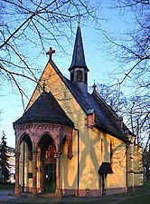
Late Gothic pilgrimage church of Maria Einsiedel

Former Capuchin monastery (1929) in the style of Expressionism , next to the pilgrimage church

Remains of the destroyed Rhine bridge


Nature and sport


By reedlands am Rhein with willows and reeds which leads Rheinradweg .
The Gernsheimer Stadtwald is also popular with cyclists and joggers ; natural history hikes are also organized. The local nature and bird protection association is located here.
In 1996 an 18-hole golf course was built on the site of the abandoned Bruchhof; it has been part of the Weiland golf course network since 2006 and is being expanded to include 27 holes.
One of the best-known Gernsheim sports clubs is the Blau-Silber dance club, which is one of Germany's most successful clubs in the field of guard and show dance . TSG Blau-Silber is multiple Hessen, German and European champions . In 2003, the state of Hesse awarded the association the so-called Heinz Lindner Prize for its “exemplary association work” .
Regular events
- Rheinisches Fischerfest - one of the largest folk festivals on the Rhine since 1949 (weekend around the first Sunday in August)
- Street Carnival (with parade) - Mardi Gras Saturday
- Christmas Market
- Notch
- Inner city festival
- Stammtisch of the owl fountain youth
Economy and Infrastructure


Land use
The municipal area covers a total area of 4011 hectares, of which in hectares are:
| Type of use | 2011 | 2015 | |
|---|---|---|---|
| Building and open space | 366 | 382 | |
| from that | Living | 163 | 159 |
| Business | 87 | 109 | |
| Operating area | 33 | 39 | |
| from that | Mining land | 0 | 0 |
| Recreation area | 75 | 77 | |
| from that | Green area | 21st | 22nd |
| traffic area | 259 | 260 | |
| Agricultural area | 2134 | 2110 | |
| from that | moor | 0 | 0 |
| pagan | 0 | 0 | |
| Forest area | 951 | 951 | |
| Water surface | 155 | 155 | |
| Other use | 37 | 37 | |
traffic
Gernsheim is on the federal roads 44 and 426 , the Autobahn 67 , the Landesstrasse 3112 and the Kreisstrasse 203. There is a bus connection with the "Schnelllinien" 44 or 45 in the direction of Griesheim (connection to the tram to Darmstadt) and with the bus route PG in the direction of Darmstadt-Eberstadt Wartehalle Via Pfungstadt train station (with a connection to Darmstadt), which has replaced the old bus line K59 or K60. A Rhine ferry runs to Eich .
Gernsheim has a train station on the Riedbahn and a Rhine port. Both are on a siding connected that of the Gernsheimer handling and terminal operations mbH & Co. KG is operated. The port is designed for container loading.
schools
- Peter Schöffer School (primary school)
- Johannes Gutenberg School Gernsheim (Integrated Comprehensive School)
- Gernsheim high school
- Schiller School (special school)
Companies
- Merck KGaA location
- Waibel KG location
Personalities
- Peter Schöffer (around 1425–1503), printer, publisher and bookseller, born in Gernsheim
- Joseph Schmitt (around 1734–1791), composer and music publisher, born in Gernsheim
- Friedrich Lehne (1771–1836), Professor of Fine Sciences and Jacobin in Mayence, France
- Peter Joseph von Rüding (1783–1863), district administrator and honorary citizen
- Louis Gutjahr (1847–1919), entrepreneur, born in Gernsheim and honorary citizen of the city
- Valentin Herbert (1864–1933), member of the Hessian state parliament (center)
- Georg Lenhart (1869–1941), member of the Hessian state parliament (center)
- Heinrich Ille (1878–1932), pastor and member of the state parliament (center)
- August Nuss (1883–1958), member of the Hessian state parliament (center), born in Gernsheim
- August Böhm (1891–1938), Member of the State Parliament (DNVP), born in Gernsheim
- Ludwig Lenhart (1902–1971), Catholic theologian and historian
- Kassius Hallinger (1911–1991), Benedictine, church historian, born in Gernsheim
- Reinhard Waibel (1920–2003), German shipowner and founder of Waibel KG
- Martin Klose (* 1957), moral theologian, rector of the Catholic University of Mainz
- Jürgen Walter (* 1968), politician, lives in Gernsheim
- Verena Weis (* 1979), singer Indira, temporarily residing in Gernsheim
literature
- Magnus Backes, Hans Feldtkeller : Art-historical hiking guide Hessen. Stuttgart / Cologne 1984, ISBN 3-88199-133-6
- August Schuchert : Gernsheim in the Mainz cultural area . In: Yearbook for the Diocese of Mainz , vol. 2 (1947), pp. 99–130.
- Hans-Josef Becker (Red.): Heimat am Strom - Gernsheim reading book (with CD-ROM). Schöfferstadt Gernsheim am Rhein 2006. ISBN 3-00-019884-9
- Magistrate of the City of Gernsheim (Ed.): City of Gernsheim 1356–1981 . Gernsheim 1981.
- Literature about Gernsheim in the Hessian Bibliography
- Literature by and about Gernsheim in the catalog of the German National Library
Web links
- Website of the Schöfferstadt Gernsheim
- Gernsheim In: Website of the district of Groß-Gerau
- Gernsheim, district of Groß-Gerau. Historical local dictionary for Hessen. In: Landesgeschichtliches Informationssystem Hessen (LAGIS).
- Information on the community of Gernsheim. In: Hessisches Gemeindelexikon. HA Hessen Agentur GmbH , 2016.
- Link catalog on the topic of the Gernsheim community at curlie.org (formerly DMOZ )
Individual evidence
- ↑ Hessian State Statistical Office: Population status on December 31, 2019 (districts and urban districts as well as municipalities, population figures based on the 2011 census) ( help ).
- ↑ N. Fröhlich, Th. Becker: Row by row of early houses , in: Archeology in Germany 05 | 2017, p. 45.
- ↑ Formerly a Roman center, today the center in the Ried. ( Memento from September 24, 2014 in the Internet Archive ) In: echo-online.de. August 28, 2014.
- ↑ Frankfurt archaeologists discover the long sought-after Roman fort Gernsheim. ( Memento from September 24, 2014 in the Internet Archive ) Press release from the University of Frankfurt am Main, August 27, 2014.
- ↑ Roman Village discovered in Gernsheim. ( Memento from September 14, 2015 in the Internet Archive ) In: Hessenschau online. September 11, 2015, accessed September 11, 2015.
- ↑ Karl Josef Minst (transl.): Lorscher Codex (Volume 4), Certificate 2720, November 20, 908 - Reg. 3559. In: Heidelberg historical stocks - digital. Heidelberg University Library, p. 214 , accessed on February 2, 2016 .
- ↑ a b c d e Gernsheim - historical development. In: gernsheim.de. Accessed November 2012.
- ↑ Historia et commentationes Academiae electoralis scientiarum et elegantiorum literarum Theodoro-Palatinae (Acta academiae Theodoro-Palatinae) (= Historia et commentationes Academiae electoralis scientiarum et elegantiorum literarum Theodoro-Palatinae. Volume 2). Academia, Mannhemii 1770, p. 164. ( full text in Google book search)
- ↑ a b c d e f g Gernsheim, district of Groß-Gerau. Historical local lexicon for Hesse (as of July 23, 2012). In: Landesgeschichtliches Informationssystem Hessen (LAGIS). Hessian State Office for Historical Cultural Studies (HLGL), accessed on November 17, 2012 .
- ^ A b c Georg Wilhelm Justin Wagner : Statistical-topographical-historical description of the Grand Duchy of Hesse: Province of Starkenburg . tape 1 . Carl Wilhelm Leske, Darmstadt October 1829, OCLC 312528080 , p. 83 ( online at google books ).
- ^ Karl-Heinz Gerstenmeier: Hessen. Municipalities and counties after the regional reform. A documentation. Melsungen 1977, p. 251
- ↑ a b main statute. (PDF; 110 kB) §; 6. In: Website. City of Gernsheim, accessed March 2019 .
- ^ Michael Rademacher: German administrative history from the unification of the empire in 1871 to the reunification in 1990. State of Hesse. (Online material for the dissertation, Osnabrück 2006).
- ^ Grand Ducal Central Office for State Statistics (ed.): Contributions to the statistics of the Grand Duchy of Hesse . tape 1 . Darmstadt 1866, p. 43 ff . ( online at Google Books ).
- ↑ Population according to nationality groups: Gernsheim, Stadt. In: Zensus2011. Bavarian State Office for Statistics , accessed in May 2015 .
- ^ Households by family: Gernsheim, city. In: Zensus2011. Bavarian State Office for Statistics , accessed in May 2015 .
- ↑ List of offices, places, houses, population. (1806) HStAD inventory E 8 A No. 352/4. In: Archive Information System Hessen (Arcinsys Hessen), as of February 6, 1806.
- ^ Ph. AF Walther : Alphabetical index of the residential places in the Grand Duchy of Hesse . G. Jonghaus, Darmstadt 1869, OCLC 162355422 , p. 30 ( online at google books ).
- ^ Local elections 1972; Relevant population of the municipalities on August 4, 1972 . In: The Hessian Minister of the Interior (ed.): State Gazette for the State of Hesse. 1972 No. 33 , p. 1424 , point 1025 ( online at the information system of the Hessian state parliament [PDF; 5.9 MB ]).
- ↑ Local elections 1977; Relevant population figures for the municipalities as of December 15, 1976 . In: The Hessian Minister of the Interior (ed.): State Gazette for the State of Hesse. 1976 No. 52 , p. 2283 , point 1668 ( online at the information system of the Hessian state parliament [PDF; 10.3 MB ]).
- ^ Local elections 1985; Relevant population of the municipalities as of October 30, 1984 . In: The Hessian Minister of the Interior (ed.): State Gazette for the State of Hesse. 1984 No. 46 , p. 2175 , point 1104 ( online at the information system of the Hessian state parliament [PDF; 5.5 MB ]).
- ↑ local elections 1993; Relevant population of the municipalities as of October 21, 1992 . In: The Hessian Minister of the Interior (ed.): State Gazette for the State of Hesse. 1992 No. 44 , p. 2766 , point 935 ( online at the information system of the Hessian state parliament [PDF; 6.1 MB ]).
- ↑ a b community data sheet : Gernsheim. (PDF; 222 kB) In: Hessisches Gemeindelexikon. HA Hessen Agency GmbH
- ^ The population of the Hessian communities (June 30, 2005). (No longer available online.) In: Hessisches Statistisches Landesamt . Archived from the original .
- ^ The population of the Hessian communities (June 30, 2010). (No longer available online.) In: Hessisches Statistisches Landesamt . Archived from the original .
- ^ Population numbers : Gernsheim, city. In: Zensus2011. Bavarian State Office for Statistics , accessed in May 2015 .
- ^ The population of the Hessian communities (June 30, 2015). (No longer available online.) In: Hessisches Statistisches Landesamt . Archived from the original .
- ^ Religious affiliation : Gernsheim, city. In: Zensus2011. Bavarian State Office for Statistics , accessed in May 2015 .
- ^ Result of the municipal elections on March 6, 2016. 433004 Gernsheim, Schöfferstadt. Hessian State Statistical Office, accessed in April 2016 .
- ^ Result of the municipal election of March 27, 2011. 433004 Gernsheim, Schöfferstadt. Hessian State Statistical Office, accessed in October 2019 .
- ↑ Result of the municipal election of March 26, 2006. 433004 Gernsheim, St. Hessisches Statistisches Landesamt, accessed in October 2019 .
- ↑ Mayoral election 2017 at the Hessian State Statistical Office.
- ^ Result of the mayoral election of Gernsheim 2017 for the city of Gernsheim.
- ↑ Local Advisory Boards. In: website. Gernsheim community, accessed October 2019 .
- ↑ Authorization to fly a flag to the city of Gernsheim in the district of Groß-Gerau, administrative district of Darmstadt from March 12, 1953 . In: The Hessian Minister of the Interior (ed.): State Gazette for the State of Hesse. 1953 No. 13 , p. 258 , point 306 ( online at the information system of the Hessian state parliament [PDF; 2.6 MB ]).
- ↑ Gernsheim old electricity works. In: gg-online.de. Accessed November 2012.
- ^ Accusation of salami tactics. In: Echo-online. Accessed November 2012.
- ↑ Hessisches Statistisches Informationssystem In: Statistics.Hessen.
- ↑ Gernsheim train station stop. (PDF; 279 kB) Rhein-Main-Verkehrsverbund, accessed on June 5, 2017 .
- ↑ Railway Atlas Germany . 10th edition. Schweers + Wall, Cologne 2017, ISBN 3-921679-13-3 .
- ↑ Internet presence of GUT - Gernsheimer Umschlags- und Terminalbetriebsgesellschaft , accessed on December 1, 2017
