
Bischofsheim (Mainspitze)
| coat of arms | Germany map | |
|---|---|---|
.png)
|
Coordinates: 49 ° 59 ' N , 8 ° 21' E |
|
| Basic data | ||
| State : | Hesse | |
| Administrative region : | Darmstadt | |
| Circle : | Gross-Gerau | |
| Height : | 86 m above sea level NHN | |
| Area : | 9.02 km 2 | |
| Residents: | 13,160 (Dec 31, 2019) | |
| Population density : | 1459 inhabitants per km 2 | |
| Postal code : | 65474 | |
| Area code : | 06144 | |
| License plate : | GG | |
| Community key : | 06 4 33 002 | |
| Address of the municipal administration: |
Schulstrasse 13–15 65474 Bischofsheim |
|
| Website : | ||
| Mayor : | Ingo Kalweit ( CDU ) | |
| Location of the community of Bischofsheim in the Groß-Gerau district | ||
  |
||

Bischofsheim is a municipality in Germany , belongs to the Groß-Gerau district in Hesse and has 13,160 inhabitants (as of December 31, 2019). From 1930 to 1945, Bischofsheim was a district of today's Rhineland-Palatinate state capital Mainz (see also districts of Mainz on the right bank of the Rhine ).
geography
Geographical location
Bischofsheim is located in the so-called Mainspitz triangle , the area south of the mouth of the Main between the Main and the Rhine .
Community structure
The community of Bischofsheim is not divided into districts . However, with “An den Sportstätten” and “Dr.-Hans-Böckler-Siedlung”, Bischofsheim has two parts that are separated from the center of Bischofsheim by the rail network and federal highway 43 and the federal highway 60 respectively .
With the Mainz-Bischofsheim train station, Bischofsheim is a railway junction with a marshalling yard . The station name goes back to the earlier political affiliation of the place to the city of Mainz . The community can also be reached directly via the 60 and 671 motorways.
Neighboring communities
Bischofsheim is separated from the city of Hochheim am Main ( Main-Taunus-Kreis ) in the north by the Main , in the east it borders on the city of Rüsselsheim am Main and in the south and west on the city of Ginsheim-Gustavsburg .
history
The place name does not go back to a bishop, but to the location at a bend in the Main ( bieschen = to bend).
Bischofsheim was first mentioned in historical documents in 1200 as Bissescheim circa Menum . In the following centuries it is mentioned under different place names . For example as Biscovesheim (1211), Bischophisheim (1268), Bisschabesheim (1319), Bischoffesheim (1394), Biffesheim (1529) and Mainbischoffsheimb (1659). The following entries about ownership can be found in the documents:
- In 1278 the brothers Philipp and Johann von Hohenfels sold all their goods in Bischofsheim, which they carried as fiefs from the Count of Rieneck , to the cathedral chapter of Mainz ;
- In 1288 Heinrich, vicar of the church in Oestrich, bequeathed his property in Bischofsheim to the Mainz cathedral chapter;
- In 1298 the Agnesenkloster in Mainz and the Mariengredenstift in Mainz were given goods in Bischofsheim.
- In 1579 the court belonging to the Archbishop of Mainz became the property of Landgrave Georg I of Hesse-Darmstadt .
Georg I of Hesse was the first Landgrave of Hesse-Darmstadt and inherited the offices of Rüsselsheim, Dornberg, Darmstadt, Lichtenberg, Reinheim and Zwingenberg from his father Philip I of Hesse . Until 1820, Bischofsheim belonged to the Rüsselsheim office , from 1821 to the Dornberg district of the Starkenburg province of the Grand Duchy of Hesse , which was founded in 1806 under pressure from Napoleon .
The statistical-topographical-historical description of the Grand Duchy of Hesse reports on Bischofsheim in 1829:
"Bischofsheim (L. Bez. Dornberg) Lutheran parish village; 3 1 / 4 St. Dornberg, 3 / 4 St. from the Rhine and 1 / 4 located St. from Main, has 92 houses and 668 inhabitants. That are up to 48 Jews Lutheran. - Herr von Falkenstein probably got the place from Herr von Munzenberg, and after the first outcome it came partly to Mainz, partly to Herr von Eppenstein. Philipp, Count von Katzenellenbogen, received the latter share in 1478 by purchase from Gottfried von Eppenstein, and for the other half, together with the court, Mainz renounced all claims in 1579 for a sum of money. The church belonged to the St. Bartholomäusstift in Frankfurt. "
Bischofsheim is commonly known as the "railway community". After 1865, the town experienced a tremendous upswing with the expansion of the Hessian Ludwig Railway from Darmstadt to Mainz, which was then part of Hessen-Darmstadt. Many workers , the Ludwigsbahn built , settled with their families in Bischofsheim. From the turn of the 19th to the 20th century until the 1960s, the Mainz-Bischofsheim train station also developed into one of the largest freight yards in southwest Germany. The station has lost this status since the 1970s.
Bischofsheim was a district of Mainz from 1930 to 1945 . After the incorporation by the city of Mainz on January 1, 1930, the previous mayor Georg Fischer was the mayor, who was replaced by party comrade Fritz Eitel after the National Socialist takeover, to whom the neighboring districts of Ginsheim and Gustavsburg were also assigned. During this term of office the discrimination of the Jewish fellow citizens began, which with the pogrom night of 9/10 November 1938 peaked. The Jewish population remaining in Bischofsheim was largely victims of the Holocaust . During the Second World War , the place was badly affected. From September 9, 1942, Bischofsheim was bombed several times by British and US aircraft squadrons because of its importance as a traffic junction . Half of the town and the Mainz-Bischofsheim marshalling yard were destroyed. On January 13, 1945, 119 Bischofsheim citizens, 14 forced laborers and 3 soldiers stationed in Bischofsheim were killed in an Allied bomb attack. After the war, the French and US occupation powers established the Rhine as the border of their occupation zones. The Mainz urban area in the French zone came to the newly founded state of Rhineland-Palatinate in 1947, and the Mainz districts on the right bank of the Rhine in the US zone to the previously newly formed Greater Hesse (today's state of Hesse). While the three districts north of the Main ( Mainz-Amöneburg , Mainz-Kastel , Mainz-Kostheim ) were assigned to the city of Wiesbaden , Bischofsheim and the neighboring Ginsheim-Gustavsburg became independent communities again in the Groß-Gerau district. The legal position of the reorganization of Bischofsheim, Ginsheim and Gustavsburg as well as AKK to the city of Mainz is under constant discussion. While the Mayor of Mainz, Franz Stein, called for the reorganization of all five Mainz suburbs in 1969, his successor Jockel Fuchs (SPD) limited this to the AKK suburbs in the mid-1980s, which are administered in trust by the city of Wiesbaden. A state border system in connection with a federalism reform depends on the will of political decision-makers to U. to realize new incorporation contracts for a reunification of the city of Mainz.
Territorial history and administration
The following list gives an overview of the territories in which Bischofsheim was located and the administrative units to which it was subordinate:
- before 1479: Holy Roman Empire , half of each: County Katzenelnbogen , Upper County Katzenelnbogen , Amt Dornberg and Kurmainz
- from 1479: Holy Roman Empire, half each: Landgraviate of Hesse , Upper County of Katzenelnbogen, Office of Rüsselsheim and Kurmainz
- from 1567: Holy Roman Empire, half each: Landgraviate Hessen-Darmstadt , Obergraveland Katzenelnbogen, Amt Rüsselsheim and Kurmainz
- from 1579: Holy Roman Empire, Landgraviate of Hessen-Darmstadt (by purchase), Upper County of Katzenelnbogen, Office of Rüsselsheim
- from 1803: Holy Roman Empire, Landgraviate Hessen-Darmstadt, Principality of Starkenburg , Rüsselsheim Office
- from 1806: Grand Duchy of Hesse , Principality of Starkenburg, Rüsselsheim Office
- from 1815: German Confederation , Grand Duchy of Hesse, Province of Starkenburg , Rüsselsheim Office
- from 1821: German Confederation, Grand Duchy of Hesse, Starkenburg Province, Dornberg District District (separation between justice ( Groß-Gerau District Court ) and administration)
- from 1832: German Confederation, Grand Duchy of Hesse, Province of Starkenburg, District of Groß-Gerau
- from 1848: German Confederation, Grand Duchy of Hesse, Darmstadt administrative district
- from 1852: German Confederation, Grand Duchy of Hesse, Province of Starkenburg, District of Groß-Gerau
- from 1866: Grand Duchy of Hesse, Starkenburg Province, Groß-Gerau district
- from 1871: German Empire , Grand Duchy of Hesse, Starkenburg Province, Groß-Gerau district
- from 1918: German Empire, People's State of Hesse , Starkenburg Province, Groß-Gerau district
- from 1930: German Empire, People's State of Hesse, Province of Rheinhessen , City of Mainz
- from 1938: German Empire, People's State of Hesse, City of Mainz (In the course of the territorial reform in 1938 , the three Hessian provinces of Starkenburg, Rheinhessen and Upper Hesse are dissolved.)
- from 1945: American occupation zone , Greater Hesse , Darmstadt administrative district, Gross-Gerau district
- from 1949: Federal Republic of Germany , State of Hesse , Darmstadt district, Groß-Gerau district
jurisdiction
The competent jurisdiction was during the affiliation to Hesse from 1821 to 1879 the district court Großgerau and from 1879 the resulting district court Groß-Gerau . While Bischofsheim belonged to Mainz from 1931 to 1945, the Mainz District Court was responsible, and with the return of Bischofsheim to the Groß-Gerau district, the Groß-Gerau District Court again.
Outsourcing
On February 1, 1975, parts of the area with then around 80 inhabitants were assigned to the neighboring community of Ginsheim-Gustavsburg.
population
Population structure
According to the 2011 census , there were 12,552 residents in Bischofsheim on May 9, 2011. These included 1804 (14.4%) foreigners of whom 532 came from outside the EU , 1026 from other European countries and 246 from other countries. 17.4% of the German residents had a migration background . The inhabitants lived in 2185 households. Of these, 619 were single households , 570 couples without children and 724 couples with children, as well as 229 single parents and 43 shared apartments .
Population development
| • 1629: | 34 house seats |
| • 1791: | 385 inhabitants |
| • 1800: | 468 inhabitants |
| • 1806: | 512 inhabitants, 80 houses |
| • 1829: | 668 inhabitants, 92 houses |
| • 1867: | 1203 inhabitants, 170 houses |
| Bischofsheim: Population from 1791 to 2015 | ||||
|---|---|---|---|---|
| year | Residents | |||
| 1791 | 385 | |||
| 1800 | 468 | |||
| 1806 | 512 | |||
| 1829 | 668 | |||
| 1834 | 745 | |||
| 1840 | 800 | |||
| 1846 | 888 | |||
| 1852 | 907 | |||
| 1858 | 969 | |||
| 1864 | 1,170 | |||
| 1871 | 1,403 | |||
| 1875 | 1,514 | |||
| 1885 | 1,854 | |||
| 1895 | 2,264 | |||
| 1905 | 3,670 | |||
| 1910 | 4,456 | |||
| 1925 | 5,438 | |||
| 1939 | 6,438 | |||
| 1946 | 7,035 | |||
| 1950 | 7,813 | |||
| 1956 | 8,677 | |||
| 1961 | 9,731 | |||
| 1967 | 10,255 | |||
| 1970 | 10.154 | |||
| 1972 | 10,984 | |||
| 1976 | 12,000 | |||
| 1984 | 11,940 | |||
| 1988 | 12,563 | |||
| 1992 | 12,895 | |||
| 2000 | 12,200 | |||
| 2005 | 12,279 | |||
| 2010 | 12,645 | |||
| 2011 | 12,552 | |||
| 2015 | 12,961 | |||
| Data source: Historical municipality register for Hesse: The population of the municipalities from 1834 to 1967. Wiesbaden: Hessisches Statistisches Landesamt, 1968. Further sources:; 1972 :; 1976 :; 1984 :; 1988 :; 1992 :; 2000 :; 2005 :; 2010 :; 2011 census; 2015: | ||||
Religious affiliation
| • 1829: | 620 Lutheran (= 92.81%), 48 Jewish (= 7.19%) inhabitants |
| • 1961: | 6467 Protestant (= 66.46%), 2936 Catholic (= 30.17%) residents |
| • 2011: | 3990 Protestant (= 31.8%), 3380 Catholic (= 26.9%), 170 Orthodox (= 1.4%), 550 non-believers (= 4.4%), 4390 other (= 35.0%) residents |
Gainful employment
The municipality in comparison with the district, administrative district Darmstadt and Hesse:
| year | local community | district | Administrative district | Hesse | |
|---|---|---|---|---|---|
| Employees subject to social security contributions | 2017 | 2,089 | 98,042 | 1,695,567 | 2,524,156 |
| Change to | 2000 | −5.6% | + 5.4% | + 16.1% | + 16.0% |
| of which full-time | 2017 | 67.3% | 75.9% | 72.8% | 71.8% |
| of which part-time | 2017 | 32.7% | 24.1% | 27.2% | 28.2% |
| Only marginally paid employees | 2017 | 502 | 13,048 | 224.267 | 372.991 |
| Change to | 2000 | + 26.1% | −9.6% | + 9.0% | + 8.8% |
| Branch | year | local community | district | Administrative district | Hesse |
|---|---|---|---|---|---|
| Manufacturing | 2000 | 27.0% | 43.8% | 27.0% | 30.6% |
| 2017 | *)% | 33.2% | 20.4% | 24.3% | |
| Commerce, hospitality and transport | 2000 | 48.6% | 27.6% | 26.4% | 25.1% |
| 2017 | 48.3% | 27.9% | 24.7% | 23.8% | |
| Business services | 2000 | 10.3% | 14.0% | 25.1% | 20.2% |
| 2017 | 12.0% | 19.9% | 31.6% | 26.1% | |
| other services | 2000 | 12.3.9% | 13.7% | 20.1% | 22.5% |
| 2017 | 22.0% | 18.6% | 23.0% | 25.4% | |
| Other (or without assignment) | 2000 | 1.7% | 1.0% | 1.4% | 1.5% |
| 2017 | 17.7% | 0.5% | 0.3% | 0.4% |
*) anonymized
religion
Christian communities
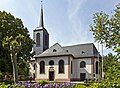
The first evidence of the existence of a church dates back to 1211. In 1267 an ecclesia is mentioned and later a parish church . As patron is Giles mentioned and 1267 gives provost of St. Victor in Mainz the patronage of the canons of his pen. The parish church probably burned down in the Thirty Years War around 1635. In 1650 the community received new stalls through a donation and in 1680 the choir was rebuilt. In 1740 an extension was decided which was financed by the St. Viktorstift and the community . The extension to the baroque building , which has been preserved until today, took place in 1747/48.
Until the middle of the 19th century, Bischofsheim was a purely Protestant village; the small St. Joseph's Church was only built in 1902. With the increasing number of Catholics , today's Christ the King Church was consecrated in 1926. Since the introduction of the Feast of Christ the King by Pope Pius XI. in 1925 this was the first church in Germany to be consecrated to Christ the King. With the Christkönigskirche in Bischofsheim, the master builder Professor Dominikus Böhm created a much-criticized and at the same time noted work in the modern sacred architectural style. Today the church is one of the programmatic buildings of modern German church architecture. After the Second World War, the number of Catholics increased particularly strongly due to the influx of refugees and expellees from the Egerland (compare Egerländer Gmoi ).
The Catholic deanery of Rüsselsheim of the Diocese of Mainz and the Protestant deanery of Groß-Gerau-Rüsselsheim of the Evangelical Church in Hesse and Nassau are responsible as church administrations for Bischofsheim today .
Jewish community in Bischofsheim
A Jewish community had existed in Bischofsheim since the 18th century , which was wiped out in 1938/42 . In 1770 three local Jewish families are named. The Jewish community was officially founded in 1826. Before that, the Jews in Bischofsheim were part of the community in Rüsselsheim. The Jewish people who died in Bischofsheim were buried in the Groß-Gerau cemetery.
The population grew rapidly in the course of the 19th century. While there were only 6 Jewish families in 1815, the community already had 48 Jewish inhabitants in 1828 (7.2% of a total of 668 inhabitants), 71 in 1861 (6.5% of a total of 1,088 inhabitants), 82 in 1871, 64 in 1880 (3.8 % of 1,702), 1895 63, 1900 68 (2.3% of 2,986), 1910 46 (1.0% of 4,456). The decline is due to the emigration to the large cities in the area after the unification of the empire, whereby Frankfurt, now Prussian, was the main attraction.
The Jewish families originally made a living from the cattle trade, agricultural products and goods. Since equality in the second half of the 19th century, they also opened shops and businesses.
The Jewish community owned a synagogue (Frankfurter Straße 48), a school ( jeschiva ) and a ritual bath ( mikwe ) in the basement of the synagogue. There has been a memorial plaque opposite the building since 1988. A religion teacher was also active as a prayer leader ( Chasan ) and slaughterer ( Schochet ). The community belonged to the Orthodox District Rabbinate Darmstadt II.
After the synagogue narrowly escaped destruction in the November pogrom of 1938, the building was converted into a residential building with an inn.
A memorial stone to the Jewish community has been located on Marienplatz since 1988 .
With the Holocaust, Jewish life in Bischofsheim died out completely.
Islamic religious communities
With the influx and the partial naturalization of guest workers mainly from Turkey , a Turkish- Islamic community has also emerged in Bischofsheim since the 1970s . Some of the members of the Muslim faith, especially from Pakistan, belong to the Ahmadiyya movement. In addition, some Muslims do not belong to the Sunni direction, but are Alevis , some of whom are of Kurdish descent. While the Ahmadiyya supporters visit their religious center in the Bait ul-Ghafur mosque in Gustavsburg, there are several mosques for the Sunni Muslims in Rüsselsheim am Main. The Alevi community is associated with Ginsheim-Gustavsburg .
politics
Community representation
The local elections on March 6, 2016 produced the following results, compared to previous local elections:
| Parties and constituencies |
% 2016 |
Seats 2016 |
% 2011 |
Seats 2011 |
% 2006 |
Seats 2006 |
% 2001 |
Seats 2001 |
||
| SPD | Social Democratic Party of Germany | 37.0 | 12 | 42.3 | 13 | 38.9 | 12 | 51.9 | 16 | |
| CDU | Christian Democratic Union of Germany | 23.3 | 7th | 25.7 | 8th | 26.8 | 8th | 34.4 | 11 | |
| GALB | GALB Alliance 90 / The Greens | 10.3 | 3 | 18.2 | 6th | 11.4 | 4th | 13.7 | 4th | |
| BFW | Bischofsheimer Free Community of Voters | 29.3 | 9 | 13.8 | 4th | 22.8 | 7th | - | - | |
| total | 100.0 | 31 | 100.0 | 31 | 100.0 | 31 | 100.0 | 31 | ||
| Voter turnout in% | 47.1 | 48.8 | 49.9 | 57.1 | ||||||


The constituent meeting of the municipal council took place on April 20, 2016. Here the member of the state parliament, Sabine Bächle-Scholz (CDU), was elected as the new chairman of the municipal council. The following people were elected as councilors to the community council:
- SPD: Marion Schorr, Wolfgang Schneider
- CDU: Katharina Manier, Helmut Schmid
- BFW: Reinhold Rothenburger ( First Alderman ), Christiane Schmitt, Klaus Zahn
- GALB: Karin Wehner.
mayor
Ingo Kalweit (CDU) has been mayor since July 1, 2017. He was elected in the runoff election on April 2, 2017 with 55.45% of the votes cast and replaces the previous social-democratic incumbent Ulrike Steinbach.
coat of arms
The coat of arms of the municipality of Bischofsheim consists of a horizontally divided shield: Above in blue a lion growing out of the division, crowned and armored in gold, divided five times by silver and red (" Bunter Löwe "); at the bottom two circles with black borders that are connected by an arch and are reminiscent of glasses. However, the image below can already be seen on a Bischofsheim court seal from 1582. Permission to use the coat of arms was granted by the People's State of Hesse on October 27, 1926 and is based on the old court seal.
Community partnerships
The community of Bischofsheim maintains the following municipal partnerships :
-
 Poland : Dzierżoniów (Reichenbach in the Owl Mountains)
 -
 United Kingdom : Crewe and Nantwich , a borough in Cheshire from 1974 to 2009 , since then part of the Unitary Authority Cheshire East
Bischofsheim has maintained Crewe and Nantwich (approx. 70,000 inhabitants - railway junction and former headquarters of Rolls-Royce, today Bentley works in Central England in the county of Cheshire (south of Manchester) in the United Kingdom) and approx. 35,000 inhabitants with Dzierżoniów in Lower Silesia ( formerly Reichenbach in the Owl Mountains) in Poland a partnership. Various exchange and partnership visits strengthen the contacts. On the English side, CANTA (association for the preparation and implementation of exchange programs, including with Macon, France) was established, while a partnership association was founded in Bischofsheim in 2002.
Culture and sights
museum
The local museum of local history is housed in the "Old Town Hall". It has a collection on the railway culture of the community and is looked after by the local history and history association. In addition to the exhibition, various cultural events are held here throughout the year. In addition, there is a branch of the Bischofsheimer registry office in the historical building.
Buildings

Sights are the Protestant baroque church , the early modern Catholic Christ the King Church by Dominikus Böhm and the historic half-timbered buildings . The Catholic Christ the King Church was the first church with this patronage in Germany after the festival of the same name was introduced in the Catholic liturgy in 1925. Until the 1960s, it was considered one of the most important modern church buildings in Germany in terms of architectural history. In 1926 Dominikus Böhm designed a parabolic solid concrete church which - based on the surrounding residential buildings and the neighboring Opel works in Rüsselsheim am Main - is completely clinkered on the outer facade.
The water tower is also significant (guided tours are offered free of charge). The Mainz-Bischofsheim passenger and freight station, which is under monument protection , survived the Second World War unscathed. Until the renovation in 2003, the reception building was painted green. With funds from the Simple Urban Renewal , a former railway transformer building was converted into a multifunctional meeting place. Structurally valuable building fabric in the Bauhaus style is located in the Jerusalem district at the freight station.
Evangelical baroque church

Catholic Christ the King Church

Museum in the old town hall

Seniorenpark Schulstrasse

Library and Palazzo Schulstrasse

Museum in the old town hall

Half-timbered house Krone , oldest building in the community

Stele to mark the 50th parallel on the Main

Rathausplatz Bischofsheim

Bischofsheim footbridge


Regular events
The Bischofsheimer Curb regularly takes place on the first weekend in September, starting on Saturday at 3 p.m. until the following Tuesday. It is a street notch in the center of the village. The traditional Notch parade takes place on Sundays through the town. An important part of the curb are various stages on which live music is played.
Synonyms
Bischofsheim is designated as follows:
- Bischofsheim (Groß-Gerau district) , for example in the RMV timetable information .
- Mainz-Bischofsheim on the part of Deutsche Bahn .
- Bischofsheim near Rüsselsheim , for example in the telephone book of Deutsche Telekom .
- Bischem , Bischofsheimer citizens are also called Bischemer ( Hessian dialect ).
Economy and Infrastructure
Land use
The municipal area covers a total area of 902 hectares, of which in hectares are:
| Type of use | 2011 | 2015 | |
|---|---|---|---|
| Building and open space | 216 | 225 | |
| from that | Living | 122 | 122 |
| Business | 35 | 35 | |
| Operating area | 7th | 7th | |
| from that | Mining land | 0 | 0 |
| Recreation area | 30th | 31 | |
| from that | Green area | 22nd | 23 |
| traffic area | 208 | 209 | |
| Agricultural area | 363 | 344 | |
| from that | moor | 0 | 0 |
| pagan | 0 | 0 | |
| Forest area | 16 | 23 | |
| Water surface | 30th | 30th | |
| Other use | 33 | 33 | |
Companies
The economy in Bischofsheim is characterized by its proximity to Opel Automobile GmbH and Frankfurt Airport . Mostly logistics service providers have settled in Bischofsheim. There are also various specialist and consumer markets.
education
Library
The community of Bischofsheim has its own public library.
schools
The only school in Bischofsheim is the Georg Mangold School, a primary school. The school is supported in its activities by its own association.
traffic
railroad
The station Mainz-Bischofsheim , station of the municipality Bischofsheim, is an important railway junction in the Rhine-Main area . It is an important freight station , where numerous freight trains are formed.

With the Hessian Ludwig Railway , the connection between Mainz, Darmstadt and Aschaffenburg , the railway reached the community in 1858. Later the Mainbahn branched off from the Ludwigsbahn to Frankfurt am Main . After the Hochheim Main Bridge was built, there was also a connection to the Taunus Railway (Kostheim branch) and to the bypass line, which joins the line from Wiesbaden shortly before the Kaiser Bridge (Mainz) and enables both the bypassing of Mainz Central Station and its approach in the opposite direction.
Bischofsheim is in the area of the Rhein-Main-Verkehrsverbund . In the station Mainz-Bischofsheim holding train - lines S8 and S9 , making direct connections to Wiesbaden, Mainz, Mainz-Kastel, Rüsselsheim am Main, Frankfurt am Main (airport, train station and the city), Offenbach and Hanau exist. Furthermore, a regional train ensures the connection with Darmstadt and on to Aschaffenburg . In addition, some regional express trains on the Frankfurt (Main) –Mainz– Koblenz route also stop . In the years 2008–2009, due to construction work, the special situation arose that the Mainz-Bischofsheim station was a replacement stop for Mainz main station for some long-distance trains. In the short term, this was the case again in the summer of 2013, when the traffic there had to be severely restricted due to a lack of staff in the "Mf" signal box in Mainz main station.
Further regular services
- Bus connections to Mainz via Gustavsburg, Mainz-Kostheim and Mainz-Kastel with the Mainz mobility lines 54, 55 and 91
- Bus connection to Ginsheim with MM line 54
- Bus connection to Rüsselsheim am Main / Raunheim to Frankfurt Airport with line 72
- Bus connection to Hochheim with line 827 (only during school hours)
Street
.jpg)
- "Mainspitz-Dreieck" of the federal motorways 60 and 671 , junction "Bischofsheim" on the A 60 (number 27) and "Gustavsburg" on the A 671 (number 6)
- Bundesstrasse 43
- State road 3482
- District roads 201, 202
Bischofsheim is one of the communities in which ride-on benches have been set up as a supplement to local public transport and to improve the mobility of people without a car (such as the elderly, young people) . For example, there is a ride-on bench in Flörsheimer Strasse near the commuter parking lot.
Personalities
- Ernst Neeb (1861–1939), art historian
- Georg Mangold (1863–1945), teacher, painter, local researcher
- Wolfgang Schneider (* 1954), cultural scientist
- Matthias Boosch (* 1982), writer
- Sabine Bächle-Scholz (* 1965), CDU politician and member of the Hessian state parliament
- DJ Taucher (* 1966), DJ and music producer
literature
- Literature about Bischofsheim in the Hessian Bibliography
- Literature on Bischofsheim in the catalog of the German National Library
Web links
- Bischofsheim. In: Website of the district of Groß-Gerau.
- Bischofsheim, district of Groß-Gerau. Historical local dictionary for Hessen. In: Landesgeschichtliches Informationssystem Hessen (LAGIS).
- Bischofsheimer history. ( Memento of October 11, 2007 in the Internet Archive ) compiled by the Heimat- und Geschichtsverein Bischofsheim.
- Link catalog on the subject of Bischofsheim at curlie.org (formerly DMOZ )
Individual evidence
- ↑ Hessian State Statistical Office: Population status on December 31, 2019 (districts and urban districts as well as municipalities, population figures based on the 2011 census) ( help ).
- ^ Wilhelm Huber: The Mainz Lexicon . Hermann Schmidt, Mainz 2002, ISBN 3-87439-600-2 .
- ↑ a b c d e f g Bischofsheim, Groß-Gerau district. Historical local dictionary for Hessen. (As of June 8, 2018). In: Landesgeschichtliches Informationssystem Hessen (LAGIS).
- ^ A b c Georg Wilhelm Justin Wagner : Statistical-topographical-historical description of the Grand Duchy of Hesse: Province of Starkenburg . tape 1 . Carl Wilhelm Leske, Darmstadt October 1829, OCLC 312528080 , p. 21 ( online at google books ).
- ^ Michael Rademacher: German administrative history from the unification of the empire in 1871 to the reunification in 1990. State of Hesse. (Online material for the dissertation, Osnabrück 2006).
- ^ Grand Ducal Central Office for State Statistics (ed.): Contributions to the statistics of the Grand Duchy of Hesse . tape 1 . Großherzoglicher Staatsverlag, Darmstadt 1862, DNB 013163434 , OCLC 894925483 , p. 43 ff . ( Online at google books ).
- ↑ a b List of offices, places, houses, population. (1806) HStAD inventory E 8 A No. 352/4. In: Archive Information System Hessen (Arcinsys Hessen), as of February 6, 1806.
- ^ Federal Statistical Office (ed.): Historical municipality directory for the Federal Republic of Germany. Name, border and key number changes in municipalities, counties and administrative districts from May 27, 1970 to December 31, 1982 . W. Kohlhammer, Stuttgart / Mainz 1983, ISBN 3-17-003263-1 , p. 366 .
- ↑ Population by nationality group: Bischofsheim. In: Zensus2011. Bavarian State Office for Statistics , accessed in May 2015 .
- ↑ Migration background in%: Bischofsheim. In: Zensus2011. Bavarian State Office for Statistics , accessed in May 2015 .
- ^ Households by family: Bischofsheim. In: Zensus2011. Bavarian State Office for Statistics , accessed in May 2015 .
- ↑ Hessen-Darmstadt state and address calendar 1791 . In the publishing house of the Invaliden-Anstalt, Darmstadt 1791, p. 123 ( online in the HathiTrust digital library ).
- ↑ Hessen-Darmstadt state and address calendar 1800 . In the publishing house of the Invaliden-Anstalt, Darmstadt 1800, p. 129 ( online in the HathiTrust digital library ).
- ^ Ph. AF Walther : Alphabetical index of the residential places in the Grand Duchy of Hesse . G. Jonghaus, Darmstadt 1869, OCLC 162355422 , p. 14 ( online at google books ).
- ^ Local elections 1972; Relevant population of the municipalities on August 4, 1972 . In: The Hessian Minister of the Interior (ed.): State Gazette for the State of Hesse. 1972 No. 33 , p. 1424 , point 1025 ( online at the information system of the Hessian state parliament [PDF; 5.9 MB ]).
- ↑ Local elections 1977; Relevant population figures for the municipalities as of December 15, 1976 . In: The Hessian Minister of the Interior (ed.): State Gazette for the State of Hesse. 1976 No. 52 , p. 2283 , point 1668 ( online at the information system of the Hessian state parliament [PDF; 10.3 MB ]).
- ^ Local elections 1985; Relevant population of the municipalities as of October 30, 1984 . In: The Hessian Minister of the Interior (ed.): State Gazette for the State of Hesse. 1984 No. 46 , p. 2175 , point 1104 ( online at the information system of the Hessian state parliament [PDF; 5.5 MB ]).
- ^ Local elections in 1989; Relevant population figures for the municipalities as of October 25, 1988 . In: The Hessian Minister of the Interior (ed.): State Gazette for the State of Hesse. 1988 No. 45 , p. 2426 , point 1049 ( online at the information system of the Hessian state parliament [PDF; 4.6 MB ]).
- ↑ local elections 1993; Relevant population of the municipalities as of October 21, 1992 . In: The Hessian Minister of the Interior (ed.): State Gazette for the State of Hesse. 1992 No. 44 , p. 2766 , point 935 ( online at the information system of the Hessian state parliament [PDF; 6.1 MB ]).
- ↑ a b Community data sheet : Bischofsheim. (PDF; 222 kB) In: Hessisches Gemeindelexikon. HA Hessen Agency GmbH
- ^ The population of the Hessian communities (June 30, 2005). (No longer available online.) In: Hessisches Statistisches Landesamt . Archived from the original .
- ^ The population of the Hessian communities (June 30, 2010). (No longer available online.) In: Hessisches Statistisches Landesamt . Archived from the original .
- ↑ Population figures : Bischofsheim. In: Zensus2011. Bavarian State Office for Statistics , accessed in May 2015 .
- ^ The population of the Hessian communities (June 30, 2015). (No longer available online.) In: Hessisches Statistisches Landesamt . Archived from the original .
- ^ Religious affiliation : Bischofsheim. In: Zensus2011. Bavarian State Office for Statistics , accessed in May 2015 .
- ^ History of the Protestant Church in Bischofsheim ( Memento from March 4, 2015 in the Internet Archive ), accessed on November 17, 2012.
- ^ History of Christ the King Church
- ^ Result of the municipal election on March 6, 2016. 433002, Bischofsheim. Hessian State Statistical Office, accessed in April 2016 .
- ^ Result of the municipal election of March 27, 2011. 433002, Bischofsheim. Hessian State Statistical Office, accessed in October 2019 .
- ^ Result of the municipal election of March 26, 2006. 433002, Bischofsheim. Hessian State Statistical Office, accessed in October 2019 .
- ↑ The bourgeois majority in Bischofsheim elects Sabine Bächle-Scholz as the new chairwoman of the community council. In: Main tip. April 22, 2016.
- ^ Second ballot for the direct election of the mayor in 2017. In: Website. Bischofsheim community, accessed October 2019 .
- ↑ Mayoral elections in Bischofsheim. Hessian State Statistical Office , accessed in October 2019 .
- ↑ town twinning. In: website. Bischofsheim community, accessed October 2019 .
- ↑ Wedding room. Bischofsheim community, accessed October 2019 .
- ↑ Bischofsheimer curb. In: website. Bischofsheim community, accessed October 2019 .
- ↑ Hessisches Statistisches Informationssystem In: Statistics.Hessen.
- ↑ Library. In: website. Bischofsheim community, accessed October 2019 .
- ↑ website. Georg Mangold School, accessed October 2019 .
- ↑ website. Friends of the Georg Mangold School, accessed in October 2019 .
- ↑ Hans-Böckler-Siedlung gets a ride-on bench. In: Frankfurter Neue Presse. January 25, 2018, accessed April 28, 2019 .
