Bundesstrasse 43
| Bundesstrasse 43 in Germany | ||||||||||||||||||||||||||||||||||||||||||||||||||||||||||||||||||||||||||||||||||||||||||||||||||||||||||||||||||||||||||||||||||||||||||||||||||||||||||||||||||||||

|
||||||||||||||||||||||||||||||||||||||||||||||||||||||||||||||||||||||||||||||||||||||||||||||||||||||||||||||||||||||||||||||||||||||||||||||||||||||||||||||||||||||
| map | ||||||||||||||||||||||||||||||||||||||||||||||||||||||||||||||||||||||||||||||||||||||||||||||||||||||||||||||||||||||||||||||||||||||||||||||||||||||||||||||||||||||
| Basic data | ||||||||||||||||||||||||||||||||||||||||||||||||||||||||||||||||||||||||||||||||||||||||||||||||||||||||||||||||||||||||||||||||||||||||||||||||||||||||||||||||||||||
| Operator: |
|
|||||||||||||||||||||||||||||||||||||||||||||||||||||||||||||||||||||||||||||||||||||||||||||||||||||||||||||||||||||||||||||||||||||||||||||||||||||||||||||||||||||
| Start of the street: |
Wiesbaden ( 50 ° 0 ′ N , 8 ° 17 ′ E ) |
|||||||||||||||||||||||||||||||||||||||||||||||||||||||||||||||||||||||||||||||||||||||||||||||||||||||||||||||||||||||||||||||||||||||||||||||||||||||||||||||||||||
| End of street: |
Hanau ( 50 ° 8 ′ N , 8 ° 56 ′ E ) |
|||||||||||||||||||||||||||||||||||||||||||||||||||||||||||||||||||||||||||||||||||||||||||||||||||||||||||||||||||||||||||||||||||||||||||||||||||||||||||||||||||||
| Overall length: | approx. 60 km | |||||||||||||||||||||||||||||||||||||||||||||||||||||||||||||||||||||||||||||||||||||||||||||||||||||||||||||||||||||||||||||||||||||||||||||||||||||||||||||||||||||
|
State : |
||||||||||||||||||||||||||||||||||||||||||||||||||||||||||||||||||||||||||||||||||||||||||||||||||||||||||||||||||||||||||||||||||||||||||||||||||||||||||||||||||||||
| Development condition: | see below | |||||||||||||||||||||||||||||||||||||||||||||||||||||||||||||||||||||||||||||||||||||||||||||||||||||||||||||||||||||||||||||||||||||||||||||||||||||||||||||||||||||
| Bundesstrasse 43 at Frankfurt Airport | ||||||||||||||||||||||||||||||||||||||||||||||||||||||||||||||||||||||||||||||||||||||||||||||||||||||||||||||||||||||||||||||||||||||||||||||||||||||||||||||||||||||
|
Course of the road
|
||||||||||||||||||||||||||||||||||||||||||||||||||||||||||||||||||||||||||||||||||||||||||||||||||||||||||||||||||||||||||||||||||||||||||||||||||||||||||||||||||||||
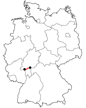
The federal highway 43 (abbreviation: B 43 ) crosses the state of Hesse in an east-west direction and thus connects Wiesbaden with Hanau .
course
The federal road begins on the north side of the Main in the Wiesbaden district of Mainz-Kastel and first leads to Mainz-Kostheim , where it crosses the Main with the Kostheimer Bridge and on the south side of the Main runs through Gustavsburg . The following route is parallel to the Mainbahn through Bischofsheim , Rüsselsheim am Main and Raunheim to Kelsterbach . From the Kelsterbach crossbar , the B 43 has been developed as a motorway-like motor road. In Frankfurt am Main , it initially runs parallel to Federal Motorway 3 past Frankfurt am Main Airport .
From the junction Frankfurt-Süd of the A 3 it is lane-separated as Mörfelder Landstrasse to the Oberforsthaus, but no longer as a motor vehicle, past the Commerzbank-Arena to the north through the Frankfurt-Sachsenhausen district. In northern Sachsenhausen it is designed as a normal city street and leads east to Offenbach-Kaiserlei . There it is directed via the federal motorway 661 and leaves it at the Taunusring junction , where it continues as Offenbacher Ringstrasse. It is then forwarded to the east via Mühlheimer Straße through Mühlheim am Main in the Offenbach district until it finally reaches Hanau , where it ends at the L 3193 (formerly B 8 ). It used to run from here via Rodenbach ("Rodenbacher Chaussee") to Gelnhausen, where it ended at the B 40. This section is characterized by a very generous cross-section, but has since been graded. Interestingly, the old B 43 between Mainz and Gelnhausen ran absolutely parallel to the B 40. This can perhaps be explained by the importance of traffic even then. Today the A 3 and A 66 as well as various feeders run parallel to this connection.
State of development
The development of the B 43 is structured as follows:
| section | Stripes | Dividing strip | comment |
|---|---|---|---|
|
|
2 | No | |
| K 202 Gustavsburg - Rüsselsheim-Kurt-Schumacher-Ring | 4th | Yes | motorway-like |
| Rüsselsheim-Kurt-Schumacher-Ring - |
4th | Yes | not free of intersections |
|
|
4th | Yes | motorway-like |
|
|
2 | No | |
|
|
4th | Yes | motorway-like |
| L 3317 Frankfurt am Main - L 3064 Mühlheim am Main | 4th | No | urban |
| L 3064 Mühlheim am Main - L 3309 Hanau | 2 | No | |
| L 3309 Hanau - L 3328 Hanau | 4th | No | urban |
| L 3328 Hanau - Wolfgang | 2 | No |
history
After the Second World War , its western end was initially on the B 26 (Frankfurter Strasse / Mainzer Strasse / Darmstädter Strasse) running through Bischofsheim . At the beginning of the 1950s it was relocated to a new building road running north on the Bischofsheim - Gustavsburg railway line and thus somewhat extended. It still ended at the B 26, but now on the outskirts of Gustavsburg. Its eastern end was initially on the B 45 in Steinheim. Later there was an extension in the Kinzig valley to Gelnhausen.
Truck toll
On the sections between Rüsselsheim and Raunheim, as well as on federal roads 43a and 45 between Dieburg and Hanauer Kreuz , the truck toll has been levied since August 1, 2012.
See also
Individual evidence
- ↑ Truck toll on federal highways: B43 between Rüsselsheim and Raunheim affected. ( Page no longer available , search in web archives ) Info: The link was automatically marked as defective. Please check the link according to the instructions and then remove this notice. In: Rhein Main Presse , February 15, 2012

