Bundesstrasse 308
| Bundesstrasse 308 in Germany | |||||||||||||||||||||||||||||||||||||||||||||||||||||||||||||||||||

|
|||||||||||||||||||||||||||||||||||||||||||||||||||||||||||||||||||
| map | |||||||||||||||||||||||||||||||||||||||||||||||||||||||||||||||||||
| Basic data | |||||||||||||||||||||||||||||||||||||||||||||||||||||||||||||||||||
| Operator: |
|
||||||||||||||||||||||||||||||||||||||||||||||||||||||||||||||||||
| Overall length: | 78 km | ||||||||||||||||||||||||||||||||||||||||||||||||||||||||||||||||||
|
State : |
|||||||||||||||||||||||||||||||||||||||||||||||||||||||||||||||||||
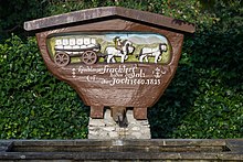
| B 308 on the Jochpass | |||||||||||||||||||||||||||||||||||||||||||||||||||||||||||||||||||
|
Course of the road
|
|||||||||||||||||||||||||||||||||||||||||||||||||||||||||||||||||||
The national highway 308 (abbreviation: B 308 ) is a German federal highway in Bavaria . It leads from Lindau (Lake Constance) via Oberstaufen and Sonthofen to the German-Austrian border ( Oberjochpass ). The B 308 is the western part of the German Alpine Road .
course
The federal highway 308 begins in the district of Lindau (Bodensee) on the A 96 ( Munich - Lindau ) AS Sigmarszell (3) as an extension of the B 31 coming from Friedrichshafen . Past Sigmarszell it goes up to Scheidegg . The further course leads towards Lindenberg im Allgäu . Shortly before Lindenberg im Allgäu, the B 308 branches off as a bypass road towards the southeast. Following the route, it now meets the B 32 . Past Oberreute , the B 308 reaches the Oberallgäu district . Here the B 308 leads over the so-called Paradise , a pass road that is notorious in winter.
The B 308 now reaches Oberstaufen . Here it meets the Allgäu Railway , in the course of which it crosses it several times. At the Great Alpsee past reaches the B 308 after Immenstadt ; here it continues north. On the outskirts of Immenstadt, the B 308 branches off to the east, crosses the Iller and meets the B 19 coming from Kempten (Allgäu) , which is similar to a motorway . From here the B 308 and B 19 run together south-east to the Sonthofen exit . This is where the federal highways separate. The B 19 continues to Oberstdorf .
The B 308 now leads west through Sonthofen along the Ostrach to Bad Hindelang . Following the course, the B 308 leads to the Oberjochpass . With 107 curves, it is the most winding road in Germany on the Oberjoch Pass. In Oberjoch , the B 308 branches off to the southwest, while the route continues to follow the B 310 that begins here to Nesselwang and Füssen .
The B 308 ends not far from the Oberjoch exit on the German- Austrian border to the Tyrolean district of Reutte , where it changes to the B 199 in the direction of Weißenbach am Lech .
history
origin
1540–1550, the road from Sonthofen via Hindelang to Oberjoch was built under Count Hug von Montfort . At the same time, Archduke Sigismund of Tyrol had a road built from Weißenbach am Lech over the Gaichtpass through the Tannheimer Valley to the Gähwinde . This was the first time that a continuous road from Illertal to Lechtal had been created, the gradients of which were steep but not difficult. As a result, Montfortstraße and Gaichtpassstraße became more and more popular and increasingly attracted the movement of goods. The new salt route soon became an important trade route between Tyrol and the Rhine , as the Arlberg was notorious for its difficulty and the Reichsstrasse via Kempten (Allgäu) too far. As early as 1662, 15,850 salt barrels (one barrel weighed about 5 quintals) were shipped on Jochstrasse. No less than 300 horses were out and about every day. At the time, that was a huge traffic that led to prosperity. The residents of the communities of the Tannheimertal as well as those of the Ostrach valley were not burdened with any levies.
Preparations for a new Jochstrasse began in 1894, and construction began in 1895. It was designed from the outset for heavy traffic, was given a respectable width and, above all, a slight gradient. The difference in altitude of 300 m from Hindelang to Oberjoch was bridged with 106 curves. The integration of the road into the landscape took place so magnificently and sensitively that today the Jochstraße is perceived as just as part of the landscape as the mountain panorama and the villages. The road was completed in 1900. In the war and after the war, the maintenance of the Jochstrasse was neglected, so that it fell into a deplorable condition. From spring to October 1952 the Jochstraße was renewed to a well-tended car road.
Previous routes and names
The road from Schattwald via Hindelang to Sonthofen was referred to as Bavarian State Road No. 119 until 1938 because the street number was based on the first letter of the starting place (S).
Bundesstrasse 308 emerged from Reichsstrasse 308 in 1949 . The R 308 followed the same route as today's B 308; with the exception of the bypasses. In 1938 ( connection of Austria ) the R 308 was extended over the Tannheimer Tal to Weißenbach am Lech ( R 17 ).
Replacements
The following sections of the route have been relocated since 1949:
- Bypass butcher, connected with relocation of the beginning of the route from the B 18 to the B 31 / A 96
- Bypass Lindenberg im Allgäu
- Bypass Thalkirchdorf with Ratholz
- Immenstadt-Sonthofen bypass with B 19
- Bypass Bad Hindelang with Vorderhindelang
- Bypass Oberjoch with route expansion to the federal border
tourism
Tourist routes
From Lindau to Oberjoch, the B 308 forms the western part of the German Alpine Road .
Viewpoints
On the Oberjochpass is the "Kanzel" lookout point with a view of the Allgäu Alps.
Scenic routes
The B 308 is one of the most attractive federal highways in Germany. Starting in the west at Lake Constance , the route crosses the Allgäu Alps with the Illertal near Sonthofen and the Oberjochpass in the east.
Web links
Individual evidence
- ↑ reichsstrassen.de.vu: The federal and former Reichsstraßen in Germany ( Memento from September 7, 2012 in the web archive archive.today ) (Retrieved November 4, 2009)


