
Oberjoch
|
Oberjoch
Bad Hindelang market
Coordinates: 47 ° 30 ′ 54 ″ N , 10 ° 24 ′ 21 ″ E
|
|
|---|---|
| Height : | 1139 (1136-1200) m |
| Residents : | 200 |
| Postal code : | 87541 |
| Area code : | 08324 |

Oberjoch ( 1136 m ) is a district of the Bad Hindelang market on a high saddle in the Bavarian-Swabian district of Oberallgäu . The place is advertised as “Germany's highest ski and mountain village”, but there are higher-lying settlements in Germany ( Feldberg (place) , Winklmoos-Alm , Gerstruben ).
geography

The climatic health resort is located in the Allgäu Alps above the Ostrachtal on the northern edge of the Limestone Alps in a high valley between the Iseler and Ornach mountains on the German Alpine Road , which leads as federal road 308 via Oberjoch to Austria with the Schattwald border station . The Oberjochpass applies with 107 curves as the most winding road in Germany .
history
Oberjoch had developed primarily on an agricultural basis. Documents from 1482 report that many "Zillenpuhlers" settled in Oberjoch. The settlers had probably been coming up from the Ostrachtal since the 15th century and were of Alemannic descent. As such, they preferred the closed group settlement, but found a road (the Roman mule track) as a guideline, so that the old place was given a long, somewhat open shape.
The Alemanni always tried to found farms that were as self-sufficient as possible, but self-sufficiency in Oberjoch will never have been entirely possible. On the other hand, the altitude above the height limit of the grain cultivation (in the northern limestone Alps at approx. 1000 m), the unfavorable soil conditions in the valley area (with a slight slope wet and therefore acidic soils) and the unfavorable climatic conditions (due to the east-west extension of the Jochpass a long, powerful blanket of snow). The natural prerequisites only allowed for a modest livestock economy, the income of which had to be improved by a sideline. The craft of the nail blacksmith , the road (accommodation for the carters, horse feeding) and the linen weaving (flax cultivation in the Ostrachtal) offered opportunities .
At the beginning of the 20th century, the living conditions of the Oberjochers deteriorated rapidly. The development of the Allgäu by the railway line Immenstadt, Sonthofen, Oberstdorf, brought about the dissolution of self-sufficiency . The farmers from Ostrachtal could now buy grain and root crops cheaper than cultivate them. The Ostrachtal, which had already given up flax cultivation in the first half of the 19th century, now completely switched to more profitable grassland farming. The Oberjoch farmers continued to operate cattle and timber. In comparison with the valley farmers, they were still worse off. The Oberjochers were also only able to participate to a small extent in a second innovation that brought new advantages to the valley farmers, namely round cheese production . The reason lies in the high amount of milk required. Due to the natural conditions, the Oberjoch farmers could only keep a few cows and therefore did not produce this amount of milk.
By the end of the 19th century, Oberjoch had reached its greatest extent as a mountain farming village. The place, with 21 houses more a hamlet than a village at the time, consisted of 13 agricultural properties, plus salt barn, customs house, road keeper's house, church and three nail smiths. Since the sideline in the nail smiths, which mainly produced nails for mountain boots, came to a complete standstill with the introduction of the knobbed rubber shoe soles around 1920, many Oberjocher decided to migrate. The map from 1930 therefore lists only seven agricultural properties.

The development of tourism then gave a new impetus in the 1930s . Despite the expansion of Jochstrasse from 1895–1900 in Oberjoch, it did not begin until 1932. In contrast to the rest of the Alpine region, where tourism began as spa tourism such as in Bad Oberdorf through the hotel "Luitpoldbad" since the 18th century and then as alpinism and summer retreat at the end of the 19th century, tourism in Oberjoch continued in its then most modern form, winter sports tourism. In 1932 the Munich-based mountain publisher and editor of the magazines "Winter" and "Bergkamerad", Rudolf Rother, built the Hotel Ingeburg, which, after the Alpengasthof Löwen (from the salt road era) and the Hochpasshaus (1927/28), became an exclusive hotel , which became the third place to stay overnight. The magazines not only advertised the new hotel, but also made the reliable snow conditions and beauty of the Oberjoch itself known in the Ruhr area.

Rother, himself a committed skier and mountaineer, had the further idea for the one developed four years before him by the sports enthusiast General Walter von Reichenau , under whose direction the Berghaus Iseler was built for a Ulm news unit. In 1934 the Reichsarbeitsdienstlager on the road to Unterjoch followed, in 1937 the police ski school (today a children's clinic, the rehabilitation clinic Santa Maria in Oberjoch), and in 1938 the Cafe Lanig. Oberjoch continued to grow almost exclusively for tourism, with several shops, guest houses and pensions being built on the street. The center developed at the local well of the Gasthof Löwen. A grocery store was opened here, the inn was given a new east wing, and a ski workshop was operated in what was once a rural property No. 9. The inauguration of the Iseler ski lift in 1940 had been hoped for a further upswing in the area, but the Second World War temporarily thwarted the plans.
In the period from mid-April to May 2, 1945, part of the command staff of the Peenemünde Army Research Institute , headed by General Walter Dornberger and Wernher von Braun, moved into quarters in the "Haus Ingeburg auf der Höhe". From there, the Reutte staff went into American captivity on May 2, 1945. In the years that followed, von Braun and his team made significant contributions to the US space program and the manned moon landings.

After 1945, Oberjoch was quickly developed further, with the town center being condensed and spa facilities being built in the periphery. The tourist sub-community built a high moor bath, developed the Komm-mit bus line, built a ski factory (HOSP-Ski), built 5 more lifts with improved slopes, a new Catholic church, holiday apartments, climatic health facilities and long, easy walks.
On the night of February 28 to March 1, 1990, the hurricane " Wiebke " devastated the trees on the lower Iseler and the Ornach almost completely. The reason was the jet effect of the topography of Hochsattel and flanking mountains. The entire area was reforested in the following 10 years in order to be able to return to proper forest management there.
Alpine training center Allgäu
The Allgäu Alpine Training Center (ATA) in Oberjoch was opened on December 16, 2005. It is the central location for promoting young German skiers. Performance-oriented ski training for the talents of tomorrow takes place here on a cordoned-off area. The training center includes a warehouse and a functional building in the finish area. The route, which is suitable for the core disciplines of giant slalom and slalom and has already proven itself in European Cup races, is used by young Allgäu drivers, the regional cadres, as well as training groups of the national teams. With the floodlight system, the basic requirements have been created, especially for school-age children, in order to be able to train at a high level and frequency in the late afternoon and early evening hours. In addition, the improved conditions benefit the recreational athletes, who can use the expanded opportunities around the Iselerbahn in the training-free times. The ATA is operated by the Allgäu Ski Association.
Data:
- Difference in altitude: 310 m
- Route length: 920 m
- Max. Gradient: 50%
- min. Gradient: 20%
- 20 floodlight masts with 200 lux illuminance
Kematsried moss

The approximately 23 hectare Kematsried-Moos (moss is a term often used in Bavarian for a moor ) is located east of Oberjoch. Almost adjacent to the village and now surrounded by the roads to Schattwald and Unterjoch , the moorland spreads out. The origin of the moor name "Kematsried-Moos" is unclear. In 1435 the name appears for the first time in writing as "Krämetzried". Perhaps there is an old, mutilated personal name in this designation, but perhaps the name also has something to do with the designation “Kremmat” for juniper . The ending -ried is more likely to be derived from the Old High German “hreod” (which means swamp floor) than it would be an indication of clearing.
The Kematsried moss is a raised bog . It owes its existence exclusively to precipitation. In contrast to the different types of fens , it is hydrologically independent of springs or groundwater or standing water surfaces (lakes, ponds). The attribute “high” has nothing to do with the location in the mountains . Rather, fully developed raised bogs show a clock-glass-shaped bulge in cross-section, which can be several meters. The Kematsried moss does not, of course, clearly show this bulge. It expands flat with no noticeable tilt on the saddle. It seems that the peat formation process in this bog has in any case partially come to a standstill. The findings of the settled plant communities also speak in favor of this. A cross path divides the moor into two different parts.

In the western part of the moor a tree-shrub vegetation has settled, as it is usually only characteristic of the edge slopes of a raised moor. In places one can speak of a sparse bog forest. The bog no longer grows in this area. In the part to the east of the moor cross-path, however, there are hardly any trees, only in the edge area to the road to Schattwald. Here you can still meet the representatives of the peat moss, which are characteristic of the raised bog: in the Rüllen (small natural watercourses) occasionally the white beaked rush ( Rynchospora alba ) and different types of peat peat moss ( e.g. the spit peat moss (Sphagnum cuspidatum) ) and on the drier sites to small clumps ( Bulten ) growing Bulttorfmoose (z. B. the Magellan peat moss (sphagnum magellanicum) ). The peat mosses have the amazing ability to absorb many times (up to 30 times) their dry weight in water in their pores. You are comparable to a sponge. The mosses usually grow when the raised bog is still growing; H. has not been artificially drained or there has been no natural outbreak of water, a few millimeters in height every year. The root parts slowly die downwards and, due to the abundant soil water and the associated lack of air, initiate the pore formation process. A raised bog slowly grows up into its characteristic clock glass shape. Different types of peat can be distinguished depending on the degree of decomposition of the vegetable raw material.
The view in the eastern moor area is dominated by extensive stands of mountain pines or pines ( mountain pine , Pinus montana or bog pine , Pinus mugo ) stretching flat on the ground and hardly taller than two meters . In between there are often heather plants such. B. considerable areas of the turf rush ( Trichophorum caespitosum ), which also indicate the final stage of bog development. In places one also meets smaller pools , i. H. Waterholes. After a long period of drought , e.g. For example, if the corrugations are anhydrous, you can see the peat in the area. The individual clumps of the Bulttorfmoos then already have light, white discoloration. These are drought phenomena. All in all, raised bogs are poorer in nutrients than fens. This also applies to the respective peat. The biodiversity of the plants in the raised bogs is also much lower than in the fens.

Fortunately, there have been no comprehensive attempts to cultivate the moor, only the edge areas of the moor have been cultivated. In the first decades of the last century and shortly before and during the Second World War, however, peat was occasionally cut for energy reasons. These interventions can also be seen in some ditches that have changed the water balance of the bog. The straight ditch that accompanies the moor cross or ring path is a testimony to these processes. The wooden huts standing here and there were partly used as a hay barn, partly also in connection with the peat cutting . In addition to the attempt at agricultural cultivation and peat cutting for heating purposes, peat was also removed for medicinal purposes ( mud baths in the Hotel Ingeburg). Such interventions are no longer possible today.
In the first post-war years, a small mud bath was still operated, but it soon became out of date and ceased to be used. After a long break, the pool was renewed in 1982/83 in around 2000 voluntary hours of work, which today can be considered an attraction in Oberjoch. The material costs were raised through donations, so that to this day no entrance fee is charged. The lifeguards are also organized on a voluntary basis. When the weather is bathing, the pool is open from 9 am to 7 pm and, despite the lack of heating, has a pleasant bathing temperature of over 20 ° C in summer due to the natural heating effect of the moorland.
Buildings
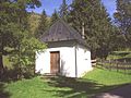
Image chapel of the salt drivers near Oberjoch

St. Jakob Chapel in Oberjoch

Holy Spirit Church in Oberjoch


- Bildkapelle : The so-called Bildkapelle stands on the old Jochstraße south of Oberjoch shortly before the steep slope into the Ostrachtal.
- St. Jakob Chapel : We only know of the first chapel that it was demolished in 1731 and that a larger chapel was built on the current site.
- Holy Spirit Church: The foundation stone was laid in 1968.
panorama

Personalities
- Hans-Peter Lanig , b. 1935, and his sister Evi were famous skiers in the 1950s. Hans-Peter won the silver medal at the 1960 Winter Olympics in Squaw Valley.
- Anton Morent (1924–2006), bus entrepreneur, mentor for tourism in Oberallgäu and holder of the Federal Cross of Merit.