
Iseler
| Iseler | ||
|---|---|---|
 Iseler north face, |
||
| height | 1876 m above sea level NHN | |
| location | Bavaria , Germany | |
| Mountains | Vilsalpseeberge , Allgäu Alps | |
| Dominance | 0.6 km → Kühgundkopf | |
| Notch height | 56 m ↓ notch to the Kühgundkopf | |
| Coordinates | 47 ° 29 '55 " N , 10 ° 25' 4" E | |
|
||
| rock | Main dolomite | |

The Iseler is a 1,876 meter high mountain in the Allgäu . It is the local mountain of Oberjoch and Bad Hindelang . It belongs to the Kühgund group, the highest mountain of which is the 1,907 meter high Kühgundkopf , and together with it forms the northern end of the Rauhhorn train . The height of the Iseler is at least 56 meters, its dominance 600 meters, with the Kühgundkopf being the reference mountain.
geology
The Iseler is a main dolomite summit on a base of Lias spotted marl and Kössen layers (i.e. alternating fine-leaved marls with dark, dense and well- banked limestone ).
Ascent
Up until a few years ago, a single chair lift ran up the Iseler. This was converted into a six- seater chairlift . In winter there is a ski area there . The following paths lead to the summit of the Iseler:
- From Oberjoch ( 1136 m ) via Ochsenalpe and Iselerplatzhütte (approx. 2 hours)
- From Oberjoch via Gundalpe and Wiedhaghütte (approx. 2 hours)
- From Oberjoch via the rear Wiedhagalpe, Kühgundkopf and Iselergrat (approx. 4 hours)
- From Bad Oberdorf ( 822 m ) via Ochsenberg (approx. 3 hours)
- From Hinterstein ( 866 m ) over the Zipfelsalpe (approx. 3 hours)
- From Schattwald ( 1072 m ) through the Stuibental (approx. 2.5 hours)
- From the mountain station of the Iselerbahn (Oberjoch) (approx. 45 min.)
- From the mountain station of the Wannenjochbahn (Schattwald) via Stuibensattel and Zipfelsalpe (approx. 1.5 hours)
- From the mountain station of the Wannenjochbahn (Schattwald) via Kühgundkopf and Iselergrat (approx. 2 hours)
Via ferrata

Since July 2008, a via ferrata has been leading up to the Iseler summit above the mountain station of the Iseler mountain railway and from there to the Kühgundkopf. The first part from the entrance to the Iseler summit is 800 meters long and has a difficulty of C at the key point Bergführerplatte . In the rest of the first part, the difficulty is B. From the summit you climb back a little before the second part descends over a smooth slab. It leads through the flank under the Iselergipfel to the Iselerscharte, here along the normal route for a while and back down into the flank and through grass and craggy terrain to the Kühgundkopf. The key point of the second part is the Schusterplatte , again with a difficulty of C. For nature conservation reasons, the via ferrata is closed for inspections between November and June. The construction of the via ferrata was supported by the outdoor company Salewa , which is why the climb is also called the Salewa via ferrata .
trip
A high path leads from Iseler via Bschießer (2000 m) and Ponten (2044 m) to the Zirleseck (1872 m). From there you reach the Willersalpe , from where you can either descend into the valley, take a break or continue the mountain hike on the Jubiläumsweg . It takes about three and a half hours from the Iselerbahn mountain station to the Willersalpe. The Rohnenspitze (1990 m) and the Gaishorn (2247 m) can be climbed with a corresponding additional expenditure of time .
photos
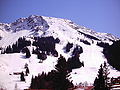
View from Oberjoch to the Iseler
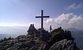
Summit cross

View from Iseler to the Stuibenkopf, in the picture below the Zipfelsalpe.

Via ferrata part II in the Schrofen area

In the first part of the via ferrata


.jpg)


Remarks
- ↑ Exact value not known, stated value is a minimum value (can be up to 19 meters higher). It was determined from the distance between the contour lines (20 meters in altitude ) on a topographic map ( scale 1: 25,000).
- ^ Salewa via ferrata Iseler Oberjoch klettersteig.de
- ↑ Gerald Schwabe: Cable car walks Allgäu , Bergverlag Rother , 2nd edition 2014, ISBN 978-3763330768 , p. 101, online at [1]
literature
- Dieter Seibert: AVF Allgäu Alps . 16th edition. Bergverlag Rudolf Rother, Munich 2004, ISBN 3-7633-1126-2 .
- Thaddäus Steiner : Allgäu mountain names . Kunstverlag Josef Fink, Lindenberg 2007, ISBN 978-3-89870-389-5 .