
Rohnenspitze
| Rohnenspitze | ||
|---|---|---|
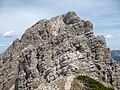
 Rohnenspitze from Gaishorn (from the south) |
||
| height | 1990 m above sea level A. | |
| location | Tyrol , Austria | |
| Mountains | Vilsalpseeberge , Allgäu Alps | |
| Dominance | 1.2 km → Ponten | |
| Notch height | 118 m ↓ Zirleseck | |
| Coordinates | 47 ° 29 '17 " N , 10 ° 28' 4" E | |
|
||
| rock | Main dolomite | |

The Rohnenspitze (also Ronenspitze and Rhonenspitze ) is a 1990 meter high mountain in the Allgäu Alps that rises in Austria . It is accessed by hiking trails and part of the Schattwald / Zöblen ski area is located on the northern flank .
Location and surroundings
The Rohnenspitze is located in the Austrian state of Tyrol . The border between the municipalities of Zöblen in the west and Tannheim in the east runs over the summit . The state border with Germany runs over the Zirleseck (1872 m) at the foot of the southern flank .
The summit of the Rohnenspitze rises above the Tannheimer Tal in the north. To the south it gathers into the Zirleseck, from where the flanks descend into the Ostrach valley . The Zirleseck is the reference point for the notch height , which is 118 meters. From there you can get to the Gaishorn (2247 m) further south or the Ponten (2044 m) in the west. The latter is the reference for the dominance of 1.2 kilometers.
geology
In the summit structure, the Rohnenspitze consists of main dolomite . This is stored on Kössen layers and Lias spotted marl .
Origin of name
The Rohnenspitze was first mentioned in 1774 by Peter Anich in the Atlas Tyrolensis as Rane Spitz . In Schmitt's map of southwest Germany (sheet 108 "Wertach") from 1797, rune tips are recorded. In a border description from 1810 it says " Vom Ronenspitz ... ". It was named after the medieval word "Rohne" for windthrow or fallen tree.
Ascent
There are marked hiking trails from different sides to the Rohnenspitze. The normal route ( route 62 ) leads from Zöblen over the north ridge, which is initially densely overgrown with pines and then stony, to the summit cross and the summit in front of it . From the Zirleseck, a path partly secured with wire rope leads through the rugged southern flank, which requires some climbing on the first ridge and surefootedness . The Zirleseck can be achieved in different ways. A variant of Via Alpina leads up through the Älpelestal near Tannheim on path 59 , from the Ostrach valley path 423 over the Willersalpe . Path 70 crosses from Ponten to the Zirleseck. Only path 71 through Pontental meets the path through the southern flank, without going over the Zirleseck.
In winter, the Rohnenspitze is a rewarding, demanding ski tour . As in summer, the ascent takes place either over the north ridge or the Zirleseck, and descends over the steep north flank.
photos

From the Wannenjochbahn mountain station
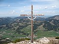
Summit cross
Summit construction

Mountain rescue hut


Web links
Individual evidence
- ↑ a b Compass hiking, bike and ski tour map: Sheet 04 Tannheimer Tal (1: 35,000). ISBN 978-3-85491-644-4 (as of February 2007).
- ↑ Federal Office for Metrology and Surveying Austria: Austrian Map online . Retrieved May 16, 2010.
- ^ A b Ernst Zettler, Heinz Groth: Alpine Club Guide - Allgäu Alps . 12th, completely revised edition. Bergverlag Rudolf Rother , Munich 1985, ISBN 3-7633-1111-4 (p. 313).
- ^ Thaddäus Steiner : Allgäu mountain names . 2nd Edition. Kunstverlag Josef Fink, Lindenberg 2008, ISBN 978-3-8987-0389-5 (p. 163).
- ↑ Dieter Seibert: Alpine Club Guide alpine - Allgäu Alps and Ammergau Alps . 17th edition. Bergverlag Rother, Munich 2008, ISBN 978-3-7633-1126-2 (p. 259).
- ↑ Kristian Rath: Allgäu ski tour guide with Kleinwalsertal and Tannheimer Tal . 6th edition. Panico Alpinverlag, Köngen 2009, ISBN 978-3-9367-4010-3 (p. 180ff).