
Shooter
| Shooter | ||
|---|---|---|
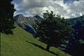
 Bschießer and Stuibenkopf from Kühgundkopf |
||
| height |
2000 m above sea level NHN 1998 m above sea level A. |
|
| location | Border Bavaria , Germany / Tyrol , Austria |
|
| Mountains | Vilsalpseeberge , Allgäu Alps | |
| Dominance | 0.6 km → Ponten | |
| Notch height | 100 m ↓ Güntle | |
| Coordinates | 47 ° 29 '16 " N , 10 ° 26' 25" E | |
|
||
| First ascent | by locals | |

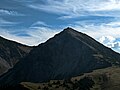
The Bschießer (in official maps also B'schießer , Tyrolean also Bscheißer ) is a 2000 meter, according to Austrian measurements 1998 meter high mountain in the Allgäu Alps .
Location and surroundings
It is located in the Rauhhornzug, southeast of the Iseler and northwest of the Ponten . The border between Germany and Austria runs over the summit. The Bschießer is at least 100 meters high and its dominance is 600 meters, with the Ponten as the reference mountain.
Origin of name
Due to its location in the German-Austrian border area, the mountain was mentioned frequently, for the first time in 1561 as in (den) Scheißer in Spiz . In 1803 there was a mention as a shit head . Der bscheißer was first noted in the Bavarian recording sheet in 1819. Similar to the mountain names Schüsser or Fürschießer , which also occur in the Allgäu Alps , the naming of the mountain indicates that "shooting down" avalanches or boulders can be expected on it.
Ascent
Marked hiking trails lead to the Bschießer. The south edge, which slopes steeply to the south, is a popular climbing tour (difficulty IV + ), which is also often combined with a ski tour.
gallery

Bschießer south side with south edge
Bschießer (the mountain to the right of the spruce) and Ponten from the west
North elevation

In the winter


literature
- Thaddäus Steiner : Allgäuer Bergnames , Lindenberg, Kunstverlag Josef Fink, 2007, ISBN 978-3-89870-389-5
- Zettler / Groth: Alpine Club Guide Allgäu Alps . Bergverlag Rudolf Rother , Munich 1984. ISBN 3763311114
Web links
References and comments
- ↑ a b Bavarian Surveying Administration : BayernAtlas. Retrieved April 25, 2018.
- ↑ a b Federal Office for Metrology and Surveying Austria: Austrian Map online (Austrian map 1: 50,000). Retrieved June 12, 2012.
- ^ Herbert Mayr: Allgäuer Wanderberge: 50 tours between Lake Constance and Füssen , 2001, Bergverlag Rother, from page 127, view in Google Books
- ↑ Exact value not known, stated value is a minimum value (can be up to 19 meters higher). It was determined from the distance between the contour lines (20 meters in altitude ) on a topographic map ( scale 1: 25,000).
- ↑ http://www.alpenverein.de/chameleon/public/37de4fb5-980d-c393-f816-6890a6e6d2d8/0727-hammerspitzen_22486.pdf
- ^ Thaddäus Steiner : Allgäu mountain names . 2nd Edition. Kunstverlag Josef Fink, Lindenberg 2008, ISBN 978-3-8987-0389-5 (p. 38).