Walser hammer tip
| Walser hammer tip | ||
|---|---|---|
|
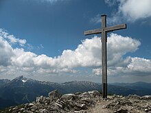
Walser hammer tip from the pulpit wall |
||
| height | 2170 m above sea level A. | |
| location | Border Vorarlberg , Austria / Bavaria , Germany | |
| Mountains | Southeastern Walsertal Mountains , Allgäu Alps | |
| Dominance | 0.7 km → Hochgehrenspitze | |
| Notch height | 30 m ↓ notch to the Hochgehrenspitze | |
| Coordinates | 47 ° 19 '34 " N , 10 ° 11' 58" E | |
|
|
||
| Normal way | from the Kleinwalsertal over the Wannenalpe | |
The Walser Hammerspitze (formerly in the Oberstdorf parlance Schüsser and in the Kleinwalsertal parlance Hammerspitze ) is a 2170 m high mountain peak and part of the Sheep Alps Group in the Allgäu Alps .
Location and surroundings
The mountain is located between the Oberstdorfer Hammerspitze ( 2260 m ) in the southwest and the Kanzelwand in the northwest. The border between Germany and Austria runs over the summit . The notch height of the Walser Hammerspitze is at least 30 meters, its dominance 700 meters, with the Hochgehrenspitze ( 2251 m ) being the reference mountain .
Naming
Due to the different names in the Kleinwalsertal in the northeast and the Oberstdorf side in the east, the naming situation of the mountains previously known as Hammerspitze and Schüsser was complicated. Therefore, in July 2013 the mountains were officially renamed to improve the situation, for example in the case of emergency calls. The German Schüsser and the Austrian Hammerspitze became the Walser Hammerspitze and the German Hammerspitze and the Austrian Schüsser became the Oberstdorfer Hammerspitze .
In the official German and Austrian maps, the two mountains were named the other way around. In the Bavarian national map the combination was Hammerspitze ( 2260 m ) and Schüsser ( 2170 m ), in the Austrian map consequently: Schüsser ( 2259 m ) and Hammerspitze ( 2170 m ).
In the revised border description of 1844 it says: "against the Schisser ... about the Schisser, who is called Hammerspitz on the Vorarlberg side." While the term hammer is an expression of the Walser German and has the meaning 'rock', the root word is Schisser Coming from the Allgäu region . It means 'the stone throwing down' and is used, for example, in the Schißer Kar in Warmatsgund on the German side. However, “Schisser” is used in the border description for the entire ridge between the Kanzelwand and the Fiderepass . Thaddäus Steiner suspects that perhaps on the Austrian side a distinction was made earlier between hammer head , i.e. the shooter, and hammer tips .
Ascent
The Walser Hammerspitze can be climbed from three directions. The easiest ascent leads from the Kleinwalsertal through the Wildental over the Wannenalpe to the summit.
The mountain can also be reached from the north via the Kanzelwand and from the south via the Hochgehrenspitze.
literature
- Dieter Seibert: Allgäuer Alpen Alpin, alpine club guide . Bergverlag Rudolf Rother, Munich 2004, ISBN 3-7633-1126-2 .
Web links
References and comments
- ↑ Exact value not known, stated value is a minimum value (can be up to 19 meters higher). It was determined from the distance between the contour lines (20 meters in altitude ) on a topographic map ( scale 1: 25,000).
- ↑ New names for two striking mountains in the Allgäu Alps. (PDF; 91 kB) German Alpine Club, July 27, 2013, accessed on July 27, 2013 .
- ↑ Bavarian Surveying Administration : BayernViewer 2.0 ( Memento of the original from December 30, 2013 in the Internet Archive ) Info: The archive link was automatically inserted and not yet checked. Please check the original and archive link according to the instructions and then remove this notice. . Retrieved January 10, 2011.
- ^ Federal Office for Metrology and Surveying Austria: Austrian Map online (Austrian map 1: 50,000) . Retrieved April 16, 2012.
- ↑ a b Thaddäus Steiner : Allgäu mountain names . 2nd Edition. Kunstverlag Josef Fink, Lindenberg 2008, ISBN 978-3-8987-0389-5 (p. 77f).
- ^ Thaddäus Steiner : Allgäu mountain names . 2nd Edition. Kunstverlag Josef Fink, Lindenberg 2008, ISBN 978-3-8987-0389-5 (p. 189).


