
Lechtal
| Lechtal | ||
|---|---|---|
 The upper Lech valley |
||
| location | Bavaria , Tyrol , Vorarlberg | |
| Waters | Lech | |
| Mountains | Lechquellen Mountains , Lechtal Alps , Allgäu Alps | |
| Geographical location | 47 ° 20 ' N , 10 ° 32' E | |
|
||
| Type | Trough valley | |
| length | 75 km | |
| climate | north alpine valley climate | |
| use | inhabited | |
| particularities | Natural park | |

The Lechtal is an alpine valley in Austria , a large part of which belongs to Tyrol and a smaller part to Vorarlberg and Bavaria . The Lech flows through it.
geography
Geographical location
Geographically, the Lech Valley is bordered by the Lechtal Alps in the south and the Allgäu Alps in the north ; the source area is the Lechquellen Mountains .
Several side valleys branch off from the Lechtal, including the Hornbachtal , the Schwarzwassertal and the Tannheimer Tal on the left . On the right side, through the Namlostal, a road connects Stanzach with Berwang and Bichlbach. Through the Bschlabertal you get to Bschlabs , Boden and over the Hahntennjoch to Imst. The Gramaistal and the Kaisertal are also right-hand side valleys of the Lech Valley. At Füssen it goes over into the Bavarian Alpine foothills .
structure
- The headwaters of the Lech in Vorarlberg includes the municipalities of Lech and Warth , it becomes the Tannberggebiet expected
- The Tyrolean Lech Valley with its side valleys includes large parts of the Ausserfern ( Reutte district ). The villages in the valley are: Steeg , Hägerau , Holzgau , Stockach , Bach , Elbigenalp , Häselgehr , Elmen , Martinau , Vorderhornbach , Stanzach , Forchach , Weißenbach am Lech , Höfen , Reutte , Breitenwang , Lechaschau , Pflach , Musau , Pinswang . The villages in the side valleys are Kaisers , Gramais , Bschlabs , Boden , Hinterhornbach , Namlos , Heiterwang , as well as Vils and Tannheim / Jungholz (on the uppermost Vils).
- at the foot of the valley enters the Alpine Foreland one

Headwaters (near Lech)

The Lech in the Reutten valley basin
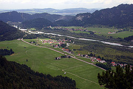
lower course of the Lech (near Musau)
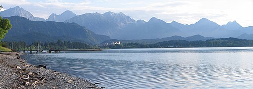
Forggensee (near Füssen, view of the valley entrance)
.jpg)


climate
The Lech Valley has a north Alpine valley climate. It is easier to reach for weather fronts and wind than inner-alpine valleys, due to the congestion towards the northwest, it is one of the wettest areas in Austria after the Bregenzerwald , the Arlberg region and the Salzkammergut . The mean annual precipitation for the years 1971-2000 in Holzgau is 1,334.8 mm and in Reutte 1,376.1 mm.
|
Monthly average temperatures and precipitation for Holzgau ( 1100 m above sea level )
Source: ZAMG
|
|||||||||||||||||||||||||||||||||||||||||||||||||||||||||||||||||||||||||||||||||||||||||||||||||||||||||||||||||||||||||||||||||||||||||||||||||||||||||||||||||||||
economy
There are predominantly industrial and commercial areas, especially in the Reutten Basin . The Vorarlberg part of the upper Lech Valley is a well-known ski region; part of the Ski Arlberg ski area in Lech and Warth is located here . While the rest of the valley is not very well developed for tourism, there is still a lift network, which consists of individual lifts in the various villages of the valley, the ski passes for Ski Arlberg have also been valid there since the 2015/16 winter season. Due to the numerous hiking opportunities and the increasing range of outdoor activities, summer tourism is also becoming increasingly important.
dialect

The Austrian Lech Valley is characterized by an extraordinary dialect situation , which divides the Lech Valley into three different dialect dreams. The communities in the uppermost valley area up to and including Steeg and Kaisers belong to the Höchst Alemannic . The middle Lechtal from Holzgau to Stanzach is assigned to the Bavarian dialect area . In the lowest valley area from Forchach in the east to Lähn (municipality of Bichlbach), Swabian dialect characters predominate . The highest Alemannic and Swabian areas are part of the Alemannic dialect area (see also border towns of the Alemannic dialect area ).
National park / nature park
A Tyrolean Lechtal National Park was planned for the Tyrolean Lechtal . It should cover an area of 4138 hectares. Since 1997, concrete efforts have been made to declare the Lechauen and their side valleys a national park. As early as 2000, the area was reported to the European Commission in Brussels as Natura 2000 (European protected area Lechtal) . At the beginning of February 2003, the official assessment procedure for a National Park Act in the Tyrolean Lechtal was initiated. In the end, the decision was made in favor of a nature park and against an internationally recognized national park, partly because of conflicts with hunting . In 2004, however, the Tyrolean provincial government decided to set up a nature reserve instead and at the same time awarded the title of nature park ( Tiroler Lech Nature Park ) .
Flora and fauna
The inner-alpine river landscape with its juniper trees , the population of the German tamarisk ( Myricaria germanica ), the abundance of birds and at least 1160 proven flowering plants are worth mentioning .
Movie
- Lechtal - mountain habitat. Documentary film, Austria, 2003, 43:40 min., Book: Maria Magdalena Koller , director: Hans-Peter Stauber, production: Interspot Film, ORF , series: Universum , summary by 3sat .
Web links
- Offic. Website of the Lechtal.at tourist office
- Tiroler Lech Nature Park
- Private portal about the Tyrolean Lech Valley
Individual evidence
- ↑ a b Central Institute for Meteorology and Geodynamics: Climate data from Austria 1971-2000
- ^ Ski Arlberg, Pool West: Tickets - Lech, Oberlech, Zürs. Retrieved August 24, 2017 .