
Nameless
|
Nameless
|
||
|---|---|---|
| coat of arms | Austria map | |
 |
|
|
| Basic data | ||
| Country: | Austria | |
| State : | Tyrol | |
| Political District : | Reutte | |
| License plate : | RE | |
| Surface: | 28.75 km² | |
| Coordinates : | 47 ° 21 ' N , 10 ° 39' E | |
| Height : | 1225 m above sea level A. | |
| Residents : | 73 (January 1, 2020) | |
| Population density : | 2.5 inhabitants per km² | |
| Postal code : | 6623 | |
| Area code : | 05674 | |
| Community code : | 7 08 23 | |
| NUTS region | AT331 | |
| Address of the municipal administration: |
Namlos 24 6623 Namlos |
|
| politics | ||
| Mayor : | Walter Zobl ( ÖVP ) | |
|
Municipal Council : (2016) (9 members) |
||
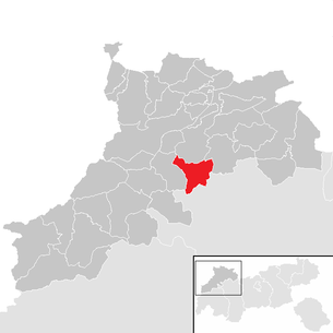
| Location of Namlos in the Reutte district | ||
  |
||
 Nameless from the southwest |
||
| Source: Municipal data from Statistics Austria | ||

Namlos is a municipality with 73 inhabitants (as of January 1, 2020) in the Reutte district in Tyrol ( Austria ). The community is located in the judicial district of Reutte , the district is Kelmen .
Surname
The place name "Namlos" is probably derived from the former colonist "Amel". For some time the place was called "Namles" before it was renamed to today's "Namlos". What is unlikely, however, is the theory that the name is derived from the term "nameless village".
geography
The small community is located in Namloser a side valley of the Lech Valley at 1,225 meters above sea level. A. The place can be reached on both sides from the Lech Valley via Stanzach (10 km) and from the Zwischenentoren via Berwang (13 km). The hamlet of Kelmen connects the Namlos Valley with the Rotlechtal . The Namlosertal flows into the Lech Valley near Stanzach.
Neighboring communities
Berwang , Imst , Reutte , Stanzach , Tarrenz
Community structure
The municipality includes the following two localities (residents as of January 1, 2020):
- Kelmen (28)
- Namlos (45)
history
The place was first mentioned in a document in 1286 . The valley was settled from Imst , and the pastures belonged to Imst until the end of the 13th century. In contrast to the rest of Ausserfern , the men from Namlos used to move abroad in winter. The dead were brought to Dormitz via the “Steinjöchl” .
On October 8, 1930, Namlos was at the epicenter of an earthquake known as the "Namlos Quake". 16 tremors up to magnitude 7.5 on the twelve-part Mercalli-Cancani-Sieberg scale or 5.3 on the Richter scale shook the village. Of 47 chimneys, 31 collapsed. The origin of the quake is believed to be under the nearby Knittelkarspitze .
Culture and sights
Despite its small size, the small mountain village is very active in some ways. Examples of this are the independent volunteer fire brigade , mountain rescue service , self-hunt, the agricultural community and the Namlos band. The elementary or secondary school has not existed since 2013.
economy
The place has been threatened with emigration for several years . More and more residents are drawn to the nearby conurbation of the district capital Reutte . The main reason for this is the far larger number of jobs. Cattle breeding is nowhere near as important as it was a few years ago. The total number of Brown Swiss farmers in Namlos is now just under 10.
tourism
For many years the main source of income for the place has been tourism. There are two inns in Namlos (Gasthof Kreuz and Gasthof Namloserhof) and an inn in the Kelmen district (Gasthof Wetterspitze). In addition, there are smaller landlords and pensions, whose range is limited to rooms and holiday apartments.
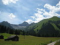
In summer, tourists find Namlos mainly because of the large number of hiking opportunities. Popular hiking destinations are the Namloser Wetterspitze , the Knittelkarspitze, the Engelspitze , the Anhalter Hut , the Dreiensee and the nearby Almdorf Fallerschein . Athletes, bikers, day visitors, families and numerous other groups of people appreciate a stay in the Namlos Valley. The Namloser Straße (L21) is a well-known and popular motorcycle route.
In winter, the nearby Berwang ski area, approx. 13 km away, offers tourist offers.
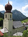
St. Martin's Church
Namloser Wetterspitze (2553 m)
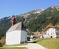
District Kelmen


Web links
- 70823 - Namlos. Community data, Statistics Austria .
Individual evidence
- ↑ Statistics Austria: Population on January 1st, 2020 by locality (area status on January 1st, 2020) , ( CSV )
- ^ Werner Hotel: On the tectonics of the North Tyrolean Limestone Alps , communications from the Geological Society in Vienna, 50th volume, 1957, page 104
- ↑ A touch of sadness about Namlos ( Memento from October 7, 2015 in the Internet Archive )
Bach | Berwang | Biberwier | Bichlbach | Breitenwang | Ehenbichl | Ehrwald | Elbigenalp | Elmen | Forchach | Grän | Gramais | Häselgehr | Heiterwang | Hinterhornbach | Courtyards | Holzgau | Young wood | Emperor | Lechaschau | Lermoos | Musau | Nameless | Nesselwängle | Pfafflar | Pflach | Pinswang | Reutte | Schattwald | Stanzach | Steeg | Tannheim | Vils | Vorderhornbach | Wängle | Weißenbach am Lech | Zöblen