
Tarrenz
|
Tarrenz
|
||
|---|---|---|
| coat of arms | Austria map | |
 |
|
|
| Basic data | ||
| Country: | Austria | |
| State : | Tyrol | |
| Political District : | Imst | |
| License plate : | IN THE | |
| Surface: | 74.59 km² | |
| Coordinates : | 47 ° 16 ' N , 10 ° 46' E | |
| Height : | 836 m above sea level A. | |
| Residents : | 2,736 (January 1, 2020) | |
| Postal code : | 6464 | |
| Area code : | 05412 | |
| Community code : | 7 02 22 | |
| NUTS region | AT334 | |
| Address of the municipal administration: |
Hauptstrasse 14 6464 Tarrenz |
|
| Website: | ||
| politics | ||
| Mayor : | Rudolf Köll (General Tarrenz List) | |
|
Municipal Council : (2016) (15 members) |
||
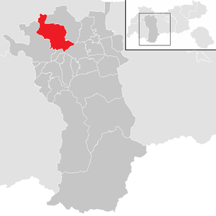
| Location of Tarrenz in the Imst district | ||
  |
||
 Tarrenz village center along Mieminger Strasse |
||
| Source: Municipal data from Statistics Austria | ||

Tarrenz is a municipality with 2736 inhabitants (as of January 1, 2020) in the Imst district ( Imst judicial district ) in the state of Tyrol ( Austria ). The name is derived from torrente (torrent).
Today Tarrenz is an agricultural (with a focus on sheep breeding) and commuter community. In recent years Tarrenz and its administration have massively increased economic growth and significantly beautified the village. In addition, “Tårrez” (as it is popularly called) is a traditional, local village with a lively club life.


geography
Tarrenz is located near Imst in the Gurgltal , on the connection to the Fernpass . The village center is densely built in a Rhaeto-Romanic manner, besides the settlement consists of several hamlets and farms on the valley floor as well as the Obtarrenz located above.
The Antelsberg nature reserve is nearby .
Community structure
Since 2019, the municipality has consisted of the only cadastral municipality of Tarrenz or the village of the same name.
Neighboring communities
Two of the eight neighboring communities are in the Reutte district (RE).
| Namlos and Berwang (both RE) | Nassereith | |
| Imst |
.svg)
|
|
| Roasting | Karres and Roppen ** | Haiming |
- ** Both only adjoin at a common point.
history
Tarrenz was first mentioned in a document in 1265 and has been referred to as a separate economic community since the 14th century. In 1811 Tarrenz becomes its own political municipality, before Tarrenz belonged to Imst.
Starkenberg
The development of Tarrenz was largely influenced by the knight family of the Starkenbergs who came to Tyrol with the Staufers and were once influential landowners in the Tyrolean Oberland . Altstarkenberg Castle was built in the 12th century. Around 1423/26 the Starkenbergers went under in a feud with Prince Frederick IV of Austria .
Neustarkenberg Castle was built between 1310 and 1329 to protect the old Via Claudia Augusta and expanded in the 15th century. In 1780 the Strele merchant family from Imst acquired the castle and expanded it into a palace. In 1810 the French occupation of the time gave them permission to brew beer commercially.
Next to the Starkenberger brewery is the Auf Starkenberg event center .
Historic mining
In the entire Gurgltal, which stretches from the Fernpass to the district capital Imst, and in its side valleys, several mining areas were developed from the late Middle Ages to the early modern period to mine lead ore. The lead mining enabled the valley to enjoy modest prosperity, but this only lasted as long as the main lead buyer, the ore smelters for smelting the Schwaz pale ore, could use the raw material. In the 16th and 17th centuries, local mining of ore-bearing rock was replaced by imports, and mining activities came to a standstill. One last very local mining in the high mountains ended after World War II.
In the mining open-air museum "Knappenwelt Gurgltal" in Tarrenz, visitors can experience the history of mining in the form of a replica plant. The museum was founded in 2008 to make the important part of the history, the mining, the Gurgltal and the community accessible to visitors again.
Bike paths
Tarrenz is on the long-distance cycle path , which runs as the Via Claudia Augusta along an ancient Roman road of the same name .
Population development

Culture and sights


- Catholic parish church Tarrenz hl. Ulrich
- Pilgrimage Chapel Sinnesbrunn Our Lady
- An open-air mining museum, the Knappenwelt Gurgltal , shows the life of miners in the 16th century and the processing of ore . In 2013 an exhibition was opened about the discovery of the grave of a healer - the healer from Gurgltal, who lived in the 17th century.
- Every four years, the carnival in the witches' village Tarrenz has an important place in the event calendar. The next carnival will take place in 2021.
- Another highlight in village life is the street festival, to which all clubs invite you every year.
Personalities
Sons and daughters of the church
- Johann Michael Greiter (around 1735–1786), painter
- Hermann Kuprian (1920–1989), educator, writer and cultural politician
- Erich Rappold (* 1960), politician
Connected to the community
- Rosa Benesch-Hennig (1903–1986), painter
literature
- Bruno Tauderer: Tarrenz . Imst, undated (community and church leader)
Web links
- 70222 - Tarrenz. Community data, Statistics Austria .
- Tarrenz , in the history database ofthe association "fontes historiae - sources of history"
- www.tarrenz.at , homepage of the municipality
- www.fasnacht-tarrenz.com
- www.knappenwelt.at
Individual evidence
- ↑ 121. Announcement of the state government of September 9, 2019 on the abandonment of localities in the municipality of Tarrenz. ris.bka.gv.at
- ↑ Bruno Tauderer: Tarrenz . Imst, undated
- ^ Peter Gstrein: The history of the mining areas in the Gurgltal region. 2008, accessed on February 5, 2018 (German).
- ↑ Peter Gstrein: Historical mining in the Gurgltal region in Tyrol…:… as well as a visit to the Knappenwelt near Tarrenz . 1 (July 30, 2011) edition. Berenkamp, 2011, ISBN 3-85093-277-X .
Arzl im Pitztal | Haiming | Imst | Imsterberg | Jerzens | Karres | Karrösten | Längenfeld | Mieming | Mils at Imst | Mötz | Nassereith | Obsteig | Oetz | Rietz | Roppen | St. Leonhard im Pitztal | Sautens | Silz | Sölden | Stams | Tarrenz | Umhausen | If it