
Umhausen
|
Umhausen
|
||
|---|---|---|
| coat of arms | Austria map | |
 |
|
|
| Basic data | ||
| Country: | Austria | |
| State : | Tyrol | |
| Political District : | Imst | |
| License plate : | IN THE | |
| Surface: | 137.31 km² | |
| Coordinates : | 47 ° 8 ' N , 10 ° 56' E | |
| Height : | 1031 m above sea level A. | |
| Residents : | 3,314 (January 1, 2020) | |
| Postal code : | 6441 | |
| Area code : | 05255 | |
| Community code : | 7 02 23 | |
| NUTS region | AT334 | |
| Address of the municipal administration: |
Village 30 6441 Umhausen |
|
| Website: | ||
| politics | ||
| Mayor : | Jakob Wolf (List Jakob Wolf - Future List Umhausen) | |
|
Municipal Council : (2016) (15 members) |
||
| Location of Umhausen in the Imst district | ||
  |
||
 Umhausen (view from Niederthai) |
||
| Source: Municipal data from Statistics Austria | ||

Umhausen is a municipality with 3314 inhabitants (as of January 1, 2020) in the Imst district ( Silz judicial district ), Tyrol ( Austria ).
geography
The municipality of Umhausen is located in the Ötztal in a valley widening on the Murkegel of the Horlachbach, scattered across various hamlets and villages. In the west are the Ötztal Alps and to the east the settlement area borders on the massif of the Stubai Alps . The peaks of both mountain ranges are over 3000 m high and partly glaciated. The Ötztal Alps represent the largest mass elevation in the Eastern Alps .

The lowest point of the municipal area is located below the Weiler Tumpen (920 m), the highest is 3288 m of Strahlkogel in the Stubai Alps . The community has a share in the Acherkogel , which at 3007 m is the northernmost three-thousand meter in Tyrol.
Neighboring communities
Neighboring communities are Arzl im Pitztal , Jerzens , Längenfeld , Oetz , Roppen , Sankt Leonhard im Pitztal , Sankt Sigmund im Sellrain , Sautens and Silz .
Community structure
The municipality includes the following six localities (population in brackets as of January 1, 2020):
- Farst (9)
- Koelels (39)
- Niederthai (343)
- East (366)
- Tumpen (664)
- Umhausen (1893)
The community consists of the only cadastral community Umhausen.
climate
|
Average monthly temperatures and precipitation for Umhausen
|
|||||||||||||||||||||||||||||||||||||||||||||||||||||||||||||||||||||||||||||||||||||||||||||||||||||||||||||||||||||||||||||||||||||||||||||||||||||||||||||||||||||||||
geology
Köfels landslide
Köfels offers a geological peculiarity : in a three billion cubic meter rockslide , pressure and frictional heat transformed gneiss into a glassy rock known as Köfelsite . You can clearly see the fracture surfaces on the mountain and the spoil dump.
The Horlachbach dammed up as a result of the landslide and the Stuibenfall later formed in the hamlet of Niederthai .
The cause of the landslide has not yet been clarified. Mark Hempsell theorized that the landslide in 3123 B.C. Was caused by an asteroid impact. This theory is currently being investigated further.
Angel wall

Outside the district of Tumpen, below Farst, there is the Engelswand, around which there are several legends. Part of the wall serves as a tourist climbing garden with over 70 routes of various levels of difficulty.
The largest part of the rock belt above the two hamlets Platzl and Lehn with the silicate rock wall and the upstream rubble at the foot of the Engelswand has been a nature reserve with an area of 39.8 hectares since 2008.
Due to their exposure, the silica-containing rubble dumps have many thermophilic locations. Shrub trees such as the common whitebeam ( Sorbus aria ) or the common hazel ( Corylus avellana ) grow in the joints . Due to the many edges and steps, the wall forms a richly structured habitat for rock plants. Here you can find pioneer vegetation with sedum and houseleek species. On the plateau steps, turf strips are formed, which mainly consist of blue grasses (genus Sesleria ). The poisonous sad tree ( Juniperus sabina ) is also common here. The Engelswand is one of the Natura 2000 protected areas.
Geo Forum
Due to the many local geological features, the Geo Forum Umhausen has been held since 2000. The Geo Forum was founded by Gunther Heissel and Helfried Mostler and takes place annually in October. National and international geologists take part in the Geo Forum.
history

Located on the second valley level of the Ötztal, Umhausen is the oldest permanent settlement in the valley. Probably around 1000 AD, Bavarian immigrants settled in the valley basin, which was initially used as a pasture area. But the Hairlach Valley, in which Niederthai is located today , was settled earlier than the inhospitable Umhauser basin, threatened by mudslides and glacier eruptions . Schwaighöfe can be found here ( "in Nidirtaige" ) from the period from 1130 to 1145, which paid interest to the Ottobeuren monastery . To the time around 7400 BC. Ch., Fire clearing in the area of the Fundusalm can be dated at 1940 m above sea level. Farst is also considered an old settlement area; Already at the time of Ötzi there were fields here that had been cleared by fire. Umhausen was a center of flax cultivation , the blue flax blossom in the coat of arms still indicates this today. The blue wave in the coat of arms represents the Stuibenfall .
Today the community is a two-season tourist destination with a few businesses.
Population development

politics

The mayor of Umhausen is Jakob Wolf , the council consists of 15 members:
- Johann Kammerlander (Vice Mayor) - List Jakob Wolf
- Franz-Josef Auer - List Jakob Wolf
- Stefan Auer - List Jakob Wolf
- Stefanie Auer - List Jakob Wolf
- Leonhard Falkner - List Jakob Wolf
- Leopold Holzknecht - List Jakob Wolf
- Gudrun Lutz - List Jakob Wolf
- Edmund Schöpf - List Jakob Wolf
- Angelika Valant - List Jakob Wolf
- Michael Kapferer - Independent Community List Tumpen
- Hubert Klotz - Independent Community List Tumpen
- Helmut Falkner - Niederthaier List
- Simon Scheiber - Niederthaier List
- Robert Bäuchl - Umhausen citizens' list
Culture and sights
Buildings

- Parish church hl. Vitus in Umhausen village with Nepomuk chapel and mortuary chapel
- Parish church hl. Martin in Tumpen a little higher above the valley floor with a cemetery chapel
- Chaplaincy Church of St. Anthony of Padua in Niederthai
- Johann Nepomuk Fountain
- Expositur Church of the Seven Painful Virgin Mary in Köfels
- Pilgrimage church Maria Schnee in Östen
Natural and cultural monuments
- Stuibenfall natural monument
- Wasserwaalweg up to the Stuibenfall: hiking trail along an irrigation system created a long time ago to secure the harvest.
Ötzi village
The Ötztal Association for Prehistoric Buildings and Local Lore, based in Umhausen, established the " Ötzi Village" in 2001 in cooperation with the Umhausen community and under the scientific direction of the University of Innsbruck (Institute for Archeology, Walter Leitner) . An archaeological open-air park, which is intended to illustrate “life, living and business in the Neolithic”, the time of Ötzi, to the visitor. A survival school is attached. Several tourist facilities have been created around the area, the last one being a bird of prey park.
Hedwig von Trapp
Hedwig von Trapp, a member of the Trapp family, lived and worked in Farst, above Umhausen, after the family choir was dissolved. This workplace, at an altitude of 1470 m , was intended to alleviate the asthma sufferer Hedwig von Trapp. Hedwig von Trapp was known from the film and musical The Sound of Music , in this film the experiences of the Trapp family were filmed. Hedwig von Trapp was portrayed in the film by the character "Brigitta". The school is still in its original state.
The larch pulling

The Larchzieh'n , in which a 35 to 40 meter long larch trunk is pulled through the village, is a centuries-old carnival custom that is carried out at intervals of several years.
Up until the 1960s, Larchzieh'n only took place if no bachelor had married in town. Since 1996, larch pulling has taken place every four to five years (1996, 2000, 2005, 2010, 2015, 2020) and is the largest event in town with several thousand visitors. It is important in the boys' practice of larch pulling that the tree trunk is pulled through the place by the exclusively single boys without interruption, i.e. in one go. The subsequent auction includes not only the symbolic larch (larch "lark"), but also other wood that is made available by agricultural communities, companies and private individuals.
Radon occurrence - Kurzentrum Umhausen
In the 1990s, occurrences of the radioactive noble gas radon were discovered in Umhausen , which were scientifically investigated in particular by the University of Innsbruck. The discovery came after statistical studies, in which a significant accumulation of lung cancer in Umhausen was found: The number of deaths in the years 1970-1991 was about four times as high as the average of the Tyrolean population. Extremely high radon concentrations were measured in closed rooms; the highest value was 274,000 Bq / m³ in July 1992 , which is more than a thousand times the recommended guide value of 200 Bq / m³. The cause of these extreme radon values are geological features in the debris cone of the Köfels landslide.
Springs with radon-containing water in the local area meet all requirements for a healing spring for chronic rheumatic diseases and pain relieving treatments. The healing water supply comprises approx. 200 million m³ and is extracted from two deep wells in the Neudorf district. Umhausen may call itself Bad Umhausen , but no use is made of this. A spa center has now been set up. It is located on a hill above Umhausen, in addition to the therapies, there are many hiking trails, mountain and mountain bike routes available.
Grantau toboggan center, 2011 World Championships
The "Federal Training Center West for tobogganing on natural tracks" has been located in Grantau since 1999. World cup races are held annually on the 955 m long track. In 2011 the natural tobogganing world championship took place on the Grantau natural toboggan run .
Personalities
- Adolf Trientl (1817–1897), priest and agricultural advisor
- Karl Marberger (1910–1995), Kronewirt and National Councilor
- Franz Pizzinini (1910–1974), painter and restorer
- Hans Marberger (1917–2002), urologist and university professor
- Ferdinand Falkner (1936–2015), journalist
- Gerald Kammerlander (* 1981), Natural Track Luge World Champion 2011
- Thomas Kammerlander (* 1990), three-time natural track toboggan overall World Cup winner 2018,2019,2020
- Hansjörg Auer (1984–2019), Austrian climber
- Alessandro Schöpf (* 1994), Austrian soccer player
- Franziska Gritsch (* 1997), Austrian ski racer
- Gilbert Soukopf (* 1959), pop singer
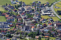
View from Farst to the village center
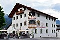
Umhausen municipal office

Rockslide from Köfels

Parish Church of Saint Vitus

Depiction of the parish church of Saint Vitus in the church

Farst village, behind the violin comb


Web links
- Umhausen , in the history database ofthe association "fontes historiae - sources of history"
- 70223 - Umhausen. Community data, Statistics Austria .
- Ötzi village
Individual evidence
- ↑ Statistics Austria: Population on January 1st, 2020 by locality (area status on January 1st, 2020) , ( CSV )
- ↑ Then a fireball shot into the valley, "A Sumerian Observation of the Köfels' Impact Event"
- ↑ Rocket researcher provided geologists with the tip Tiroler Tageszeitung from October 17, 2015
- ↑ How the Engelswand got its name: Sage on Oetztal Nature Park ( Memento of the original from July 26, 2014 in the Internet Archive ) Info: The archive link has been inserted automatically and has not yet been checked. Please check the original and archive link according to the instructions and then remove this notice. (PDF; 33 kB)
- ↑ "From the Engelswand" on Sagen.at
- ↑ Description of the climbing garden on Oetztal.com ( Memento of the original from August 20, 2008 in the Internet Archive ) Info: The archive link has been inserted automatically and has not yet been checked. Please check the original and archive link according to the instructions and then remove this notice.
- ↑ Natura 2000 protected area: data sheet for the Engelswand ( page no longer available , search in web archives ) Info: The link was automatically marked as defective. Please check the link according to the instructions and then remove this notice. (PDF; 93 kB)
- ↑ Martin Bitschnau , Hannes Obermair : Tiroler Urkundenbuch, II. Department: The documents on the history of the Inn, Eisack and Pustertal valleys. Volume 1: By the year 1140 . Universitätsverlag Wagner, Innsbruck 2009, ISBN 978-3-7030-0469-8 , p. 185-186 No. 204 .
- ↑ Dr. Gernot Patzelt, published on www.similaun.net , accessed on November 19, 2014
- ^ Dehio Tirol 1980
- ↑ Wasserwaalweg - A hike along the vital water
- ↑ http://www.salzburg.com/wiki/index.php/Hedwig_von_Trapp
- ^ Radon in Austria . Ministry of Life . August 3, 2012. Archived from the original on August 31, 2012. Info: The archive link was automatically inserted and not yet checked. Please check the original and archive link according to the instructions and then remove this notice. Retrieved October 19, 2012.
- ↑ Christian Knapp: radon problem in Umhausen . BRG Imst. 1999. Archived from the original on July 27, 2014. Info: The archive link was inserted automatically and has not yet been checked. Please check the original and archive link according to the instructions and then remove this notice. Retrieved April 9, 2011.
- ↑ Radon: From Curse to Blessing? In: 's Blattle, December 2007, pp. 4–6 ( PDF; 2.5 MB )
Arzl im Pitztal | Haiming | Imst | Imsterberg | Jerzens | Karres | Karrösten | Längenfeld | Mieming | Mils at Imst | Mötz | Nassereith | Obsteig | Oetz | Rietz | Roppen | St. Leonhard im Pitztal | Sautens | Silz | Sölden | Stams | Tarrenz | Umhausen | If it