Strahlkogel
| Strahlkogel | ||
|---|---|---|
|
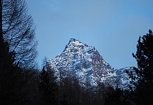
The Strahlkogel from the north |
||
| height | 3288 m above sea level A. | |
| location | Tyrol , Austria | |
| Mountains | Stubai Alps | |
| Dominance | 7.1 km → Vorderer Brunnenkogel | |
| Notch height | 506 m ↓ Winnebachjoch | |
| Coordinates | 47 ° 6 '35 " N , 11 ° 1' 9" E | |
|
|
||
| rock | Gneiss and hornblende slate | |
| First ascent | 1833 by Peter Carl Thurwieser , probably led by two chamois hunters | |
| Normal way | from the Larstighöfen near Niederthai to the Grasstaller See , over the Grasstallferner and the West Ridge as a glacier tour | |
The Strahlkogel is at 3288 m above sea level. A. the highest mountain of the Larstiger Mountains , a subgroup of the Stubai Alps in the Austrian state of Tyrol and also the highest mountain in the municipality of Umhausen .
It got its name from the mighty white, light-reflecting quartz layers that supposedly make the mountain shine . It has the shape of a regular, steep and pointed pyramid . Climbing the Strahlkogel is difficult, so it is rarely climbed, in contrast to the neighboring 3287 m high Grieskogel . The first ascent took place in 1833 by Peter Carl Thurwieser . Thurwieser's path and the exact circumstances are not known. On August 28, 1887, Ludwig Purtscheller and Fritz Drasch from Salzburg climbed the mountain again. Their way led over the west ridge, this is still the normal route today and is considered the easiest climb to the summit.
Surroundings
The Strahlkogel is a good five kilometers as the crow flies northeast of Längenfeld in the Ötztal and seven kilometers west-southwest of Lüsens in the Lüsenstal . In the east and south it is surrounded by glaciers . The steep and crevice- rich Larstigferner extends in the east up to a height of 3200 m , and in the south lies the flat but extensive Grasstallferner , which reaches up to a height of 3100 m . Adjacent mountains are in the course of ice divide between Grasstall- and semolina Further, the 3287 m high width Grießkogel , in the course of the salient Strahlkogel-west ridge of grass Staller Grießkogel with 3160 m height and in the east finally separated by the at 3032 m preferred Larstigscharte that Larstigspitze ( 3173 m ).
Bases and paths

Today's normal route to the Strahlkogel leads over the west ridge. The base for an inspection is the village of Niederthai in the Ötztal at 1538 m . From there it goes south to the Grasstallsee , then east on the Grasstallferner as an alpine tour (only to be done with appropriate equipment and experience) and over the west ridge with exposed difficult climbing of difficulty UIAA II-III to the summit. According to the literature, the walking time is around five hours. However, the Strahlkogel can also be climbed in a sometimes very difficult climb over the southern flank and the southeast ridge. The base here is the Winnebachseehütte at 2362 m , above Gries in the Sulztal .
Summit cross
A summit cross has stood on the highest point of the Strahlkogel since October 10, 1967 . For four days, young mountaineers from Umhausen carried up the individual parts made of galvanized steel and set up the necessary anchors. On September 29, 1968, the solemn consecration of the cross by Pastor Otto Gleinser took place together with many friends who were enthusiastic about the mountains. With the summit cross, a summit book was installed for the first time , the full copies of which are archived in the Chronicle in Umhausen.
For the 50th anniversary, the cross was repaired on October 26, 2017 by eight young men from Umhausen and set up again after it had sunk a few meters over the years due to subsidence of the subsurface and was visibly crooked.
Literature and map
- Walter Klier : Alpenvereinsführer Stubai Alps , Munich 2006, ISBN 3-7633-1271-4
- Eduard Richter : The development of the Eastern Alps, Volume II , Berlin, publishing house of the German and Austrian Alpine Association, 1894
- Alpine Club Map 1: 25,000, sheet 31/2 Stubai Alps, Sellrain
Individual evidence
- ↑ Clem Clements, Jonathan de Ferranti, Eberhard Jurgalski , Mark Trengove: The 3000 m SUMMITS of AUSTRIA - 242 peaks with at least 150 m of prominence , October 2011, p. 11.
- ↑ Federal Office for Metrology and Surveying Austria: Strahlkogel on the Austrian Map online (Austrian map 1: 50,000) .
- ↑ a b A summer like back then. 50 years of the summit cross on the Strahlkogel. In: OeAV section Umhausen: Strahlkogelkaleder 2018. ( online )

