Lüsenstal
| Lüsenstal | ||
|---|---|---|
|
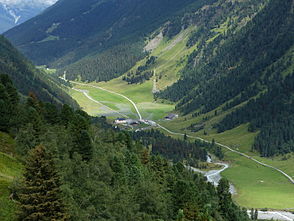
The Lüsenstal near Lüsens |
||
| location | Tyrol , Austria | |
| Waters | Melach | |
| Mountains | Stubai Alps | |
| Geographical location | 47 ° 9 '40 " N , 11 ° 8' 16" E | |
|
|
||
| height | 1200 to 1800 m above sea level A. | |
| length | 10 km | |
The Lüsenstal , also Lüsener Tal , Lisener Tal or Lisenstal , is a 10 km long side valley of the Sellraintal in the Stubai Alps in Tyrol .
geography
The Lüsenstal branches off to the south at Gries im Sellrain ( 1187 m above sea level ). In the east, a ridge runs from Windegg ( 2577 m ) over the Roten Kogel ( 2832 m ), Lüsener Villerspitze ( 3027 m ), Schafgrübler ( 2922 m ) and Rinnenspitze ( 3000 m ) to the Hinteren Brunnenkogel ( 3325 m ) and delimits the valley to the Fotschertal . In the west, a ridge that runs from Freihut ( 2625 m ) via Sömen ( 2516 m ), Lampsenspitze ( 2876 m ), Zischgeles ( 3004 m ), and Schöntalspitze ( 3003 m ) to Gleirscher Fernerkogel ( 3189 m ) separates the Lüsenstal from Gleirschtal . The end of the valley is formed by the Lüsener Ferner . Shortly before the end of the valley, the Längental branches off to the west. There is the Westfalenhaus , from which you can continue over the high alpine crossing of the Winnebachjoch ( 2782 m ) into the Sulztal .
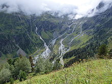
The valley is traversed by the Melach , which rises from the Lüsener Ferner, takes up the Zirmbach in Gries and continues through the Sellraintal to the Inn .
history
Since the Middle Ages, the entire high valley has been largely owned by Wilten Abbey , which used it for alpine farming and maintained Schwaigen here . The first mention of the Lüsenstal as " mons Malusinus " appears in a deed of the monastery (allegedly from 1142), which was made after the middle of the 13th century . In Kaiser Maximilian's hunting book , the valley is referred to as Under Tal im Sellrain . This Untertal stood in contrast to the St. Sigmunds or Obertal , the valley through which the Zirmbach flows and is now regarded as a continuation of the Sellrain. Just as the stream bears the continuous name Melach, the Untertal was previously regarded as the main valley. When Johann Jakob Staffler the valley in the 19th century for the first time as Liesenstal referred.
Settlement and development
There are several smaller settlements in the valley. The Rotten Reichenhöfe and Juifenau ( 1380 m ) as well as the hamlet of Narötz in the lower valley area belong to the municipality of Gries im Sellrain . The places in the upper section of the valley, the hamlet Kniepiß, the Rotte Praxmar ( 1689 m ) and the scattered houses Lüsens ( 1634 m ), are part of the municipality of St. Sigmund im Sellrain .
The valley is accessed by the 6.4 km long Praxmarer Straße (L 234) from Gries to Praxmar, as well as by the road that branches off at Kniepiß and continues following Melach to Lüsens.
Web links
literature
- Ignaz Mader : Settlement history studies on the Lüsen valley. With a collection of the place names of the valley and a name card. In: Magazine of the Ferdinandeum for Tyrol and Vorarlberg , third volume, 57th issue (1913), p. 323 (online)
Individual evidence
- ↑ Martin Bitschnau , Hannes Obermair : Tiroler Urkundenbuch , II. Department: The documents on the history of the Inn, Eisack and Pustertal valleys. Vol. 2: 1140-1200 . Universitätsverlag Wagner, Innsbruck 2012, ISBN 978-3-7030-0485-8 , p. 23-25 No. 401 (with detailed preliminary remarks).
- ↑ Otto Stolz : History of the waters of Tyrol. Schlern writings, Volume 32, Innsbruck: Wagner 1932, p. 32 ( digitized version )
- ^ Office of the Tyrolean Provincial Government (publisher): Statistisches Handbuch Bundesland Tirol 2009 , p. 22 ( PDF; 9.3 MB )


