Zischgeles
| Zischgeles | ||
|---|---|---|
|
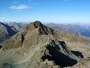
The Zischgeles from the south of the Schöntalspitze |
||
| height | 3004 m above sea level A. | |
| location | Tyrol , Austria | |
| Mountains | Stubai Alps | |
| Dominance | 1.3 km → pit wall | |
| Notch height | 135 m ↓ Scharte to Schöntalspitze | |
| Coordinates | 47 ° 7 '53 " N , 11 ° 5' 41" E | |
|
|
||
| First ascent | unknown first tourists: A. Hintner, M. Peer 1892 |
|
| Normal way | Marked trail from Praxmar | |
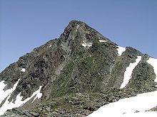
The Zischgeles (or Zischgelesspitze ) is a 3004 m above sea level. A. high mountain in the Stubai Alps in Tyrol .
Starting from Praxmar ( 1687 m above sea level , a few kilometers south of Gries im Sellrain in Lüsenstal ) there are two roughly equivalent ascent variants:
- North-east through the valley of the Marlerbach and the Satteljoch over the north ridge
- A little further south over the Köllenzeiger and south of the Oberstkogel ( 2767 m above sea level ) to the east ridge
On both ascent routes, the summit can be reached in an easy mountain tour without touching the glacier, only in the summit area is some surefootedness necessary.
In winter the Zischgeles is a popular ski touring mountain .
Literature and map
- Walter Klier : Alpine Club Leader Stubai Alps , Bergverlag Rudolf Rother , Munich 2006, ISBN 3-7633-1271-4
- Dieter Seibert: Leichte 3000er , Bruckmann Verlag, Munich 2001, ISBN 3-7654-3677-1
- Alpine Club map sheet 31/2, 1: 25,000, Stubai Alps; Sellrain , ISBN 3-928777-73-4
Web links
Commons : Zischgeles - collection of images, videos and audio files


