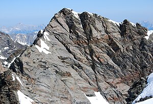
Gleirscher Fernerkogel
| Gleirscher Fernerkogel | ||
|---|---|---|
|
Gleirscher Fernerkogel from the south (Winnebacher Weißkogel) |
||
| height | 3189 m above sea level A. | |
| location | Tyrol , Austria | |
| Mountains | Stubai Alps | |
| Dominance | 3.1 km → Strahlkogel | |
| Notch height | 321 m ↓ Zwieselbachjoch | |
| Coordinates | 47 ° 6 '53 " N , 11 ° 3' 47" E | |
|
|
||
| First ascent | September 1, 1883 by Ludwig Purtscheller and Hans Schöller (tourist) | |
| Normal way | Glacier tour from the Gleirschtal over the east face | |
The Gleirscher Fernerkogel , also Gleirschfernerkogl , formerly called Roßkarspitze , is 3189 m above sea level. A. high mountain in the southern Sellrainer mountains , a subgroup of the Stubai Alps . It is located in the Austrian state of Tyrol . The name "Roßkarspitze" was given to it on the occasion of the military mapping of the area in the 1850s. Ludwig Purtscheller and Hans Schöller, a "professor from Salzburg" , undertook the first documented ascent on September 1, 1883 . Purtscheller finally gave the mountain its current name. To the east, the summit, which does not protrude much from its surroundings, emits a pronounced 500 meter long ridge.
Surroundings
The Gleirscher Fernerkogel is a good seven kilometers as the crow flies northeast of Längenfeld in the Ötztal and just under 7 km southwest of Praxmar in the Lüsenstal . In the east, two glaciers meet the mountain up to an altitude of 3,100 meters. The Gleirschferner stretches north of the east ridge , to the south lies the Weißkogelferner , which is dwindling strongly due to global warming and whose firn field is just under 300 meters long. Adjacent mountains are in the course of the east ridge, separated by the Roßkarscharte at an altitude of 3,053 meters , the rear pit wall with a height of 3,173 m , in the south the 3182 m high Winnebacher Weißkogel and in the north the sun walls , the highest elevation of which is the rear sun wall ( 3106 m ). To the west, the Gleirscher Fernerkogel slopes down into the Zwieselbachtal with a 500 meter high wall .
Bases and tours
The path of the first Steiger led from northern Gleirschtal over the Gleirschferner to the southwest on the east wall and the east ridge to the summit. This normal route runs as an alpine tour (only to be done with appropriate equipment and knowledge) today from the Pforzheimer Hut in the uppermost Gleirschtal at an altitude of 2308 meters. Over the glacier route direction is Roßkarscharte, to rockfall endangered eastern wall of Kogels in, according to the literature, moderately difficult climb in difficulty UIAA II to the summit. The direct ascent of the east ridge requires a very difficult UIAA grade IV climb. The walking time from the hut is 5 hours. Other routes to the Gleirscher Fernerkogel lead over the south ridge in UIAA grade II from the Westfalenhaus (2273 m) in 3 hours, or through the south face in difficult climbing in UIAA grade III.
Literature and map
- Walter Klier : Alpenvereinsführer Stubai Alps , Munich 2006, ISBN 3-7633-1271-4
- Eduard Richter (Hrsg.): The development of the Eastern Alps, Volume II , publisher of the German and Austrian Alpine Association, Berlin 1894
- Alpine Club Map 1: 25,000, sheet 31/2 Stubai Alps, Sellrain
Web links
Individual evidence
- ↑ Clem Clements, Jonathan de Ferranti, Eberhard Jurgalski , Mark Trengove: The 3000 m SUMMITS of AUSTRIA - 242 peaks with at least 150 m of prominence , October 2011, p. 11.
- ↑ Federal Office for Metrology and Surveying Austria: Gleirscher Fernerkogel on the Austrian Map online (Austrian map 1: 50,000) .

