Pit wall
| Rear pit wall | ||
|---|---|---|
|
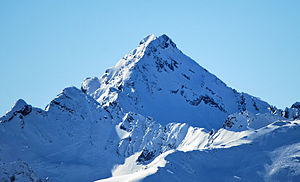
Rear (left) and front pit walls from the northeast, the Schöntalspitze in front on the left |
||
| height | 3175 m above sea level A. | |
| location | Tyrol , Austria | |
| Mountains | Stubai Alps | |
| Dominance | 1.63 km → Gleirscher Fernerkogel | |
| Notch height | 218 m ↓ Scharte to the Fernerkogel | |
| Coordinates | 47 ° 7 '4 " N , 11 ° 7' 4" E | |
|
|
||
| Type | Felsberg | |
| rock | Mica slate | |
| Normal way | Northeast Ridge ( II ) | |
The Grubenwand , also Black Wall , is a mountain in the Stubai Alps in Tyrol . It consists of two peaks, the 3175 m above sea level. A. high rear and the 3165 m high front pit wall .
topography
The pit wall lies in a mountain ridge that extends from the Gleirscher Fernerkogel towards the northeast. To the west, it drops 400 meters down to the Gleirschferner with steep cliffs. The mountain is also characterized by rocks in a south-easterly direction up to a height of 2600 m , underneath is the Längental with the Westfalenhaus . To the northeast the ridge continues to the 3008 m high Schöntalspitze . Another ridge runs from the Vorderen Grubenwand to the north, to the east of which lies a small glacier, the Zischgeles or Zischgenferner . The north-eastern front is connected to the rear pit wall by a sharp rock ridge.
ways
The normal route to the summit of the Vorderen Grubenwand leads in difficulty II over the northeast ridge. This path can also be used as a ski tour in winter . Further climbs are the north-west face (III) and the north ridge (IV). The rear pit wall can be reached via the southwest ridge (IV), the northwest wall (III) or the connecting ridge with the front pit wall (III).
Pit wall and Zischgenferner seen from Zischgeles (before 1932)
literature
- Heinrich and Walter Klier : Alpine Club Guide Stubai Alps . Rother Bergverlag, Munich 1980, ISBN 3-7633-1212-9 , p. 367-370 .


